Distance: 7.3 miles round trip on trail and cross country
Summit Elevation: 3342' (high point at trailhead)
Elevation Gain: 1331' (loss then gain)
Elevation Gain (in Empire State Buildings): 1.06
Round trip time: 7 hours
Recommended water: 124 oz.
Parking/Fees: Adventure Pass
Difficulty: Very Strenuous and Dangerous
Tanriverdi Falls (or Tanrierdi) is one of the crown jewels of the Santa Ana Mountains, and probably seen by only a handful of people each decade. There is no easy way to get there. I considered the long approach from the bottom of Hot Spring Canyon, coming from Chiquito Basin (heavy poison oak), Los Pinos ridge, and the north ridge of Old Sugarloaf, but decided descending from the top of the canyon was still the best. Note: canyoneering site ropewiki also refers to this as Salamander Canyon. Jerry Schad's Afoot and Afield in Orange County covers the hike from the bottom, a 10 hour round trip according to his write up. It also covers the hike to the second waterfall from the top, but not the wild mid-canyon section below it. Here is a part of his description:
Being in excellent physical condition, having considerable experience in cross country travel over rugged terrain, and possessing good judgement do not automaticaly guarantee that you'll be able to reach the falls and return without mishap. You must be cautious, patient, and determined too. Hazards include slippery rocks (some concealed by leaf litter), prickly vegetation, and literal forests of poison oak.I had hiked to the second waterfall in 2013 and scouted above it. The difference this time was the conviction to make it to the big falls. I would not recommend making an attempt without conviction. It is difficult and dangerous and for about an hour I was genuinely concerned that I would not make it out.

North ridge of Old Sugarloaf clogged with chaparral (scouted by Gimpilator, thanks!)
Long Canyon Road was open again and the first part was newly paved and smooth. I parked at the Falcon Campground and got ready for a fight. The pants, shirt, and socks I had on had been treated with Permethrin, a kill-ticks-on-contact chemical that you aren't supposed to spray on while wearing the clothes being treated. Serious chemical warfare. I added long gaiters, gloves, and a fleece for more brush protection. The easy part of the hike to the second falls was familiar and went quickly. I found 5 ticks on me getting to the second falls, the last one seemed to drop off on its own. The permethrin may have killed it. I decided to call the second falls "Gut Check Falls", because nothing comes easy after that. For the other falls, I used the names from the canyoneer trip report on Summitpost.org, matching up what I saw with their pictures and descriptions as well as I could. Most of the rocks in the canyon are worn as smooth as glass from the water so down climbing big falls was a non-starter. I followed a faint use trail on the right to bypass "Gut Check" and thought about descending back to the canyon, but I knew the "Single Track Falls" bypass would be required almost immediately so I stayed high on the wall trying to follow the occasional animal trail. This was very difficult as the brush got thicker. I traversed across a side canyon looking for a way to descend. I found a way to the bottom of the side canyon, then fought through hellish brush to get back to Hot Spring Canyon. What made the bushwhacking so bad was not just the native growth, but the years of run off that filled the side canyon. Small trees, boulders, and debris mixed with the native plants to create an unholy jumble. I used the machete to hack some areas, but overall, it was a negative, getting caught on things as I tried to pass under. The tick problem went away, probably because I was in such dense brush that the deer were not stupid enough to wade through. No deer, no ticks.

Algae in the canyon

Upper Hot Spring Falls

Easy obstacles at the start

Gut Check Falls (2nd falls)

Top of Single Track Falls

Bottom of Single Track Falls (from high on the wall)
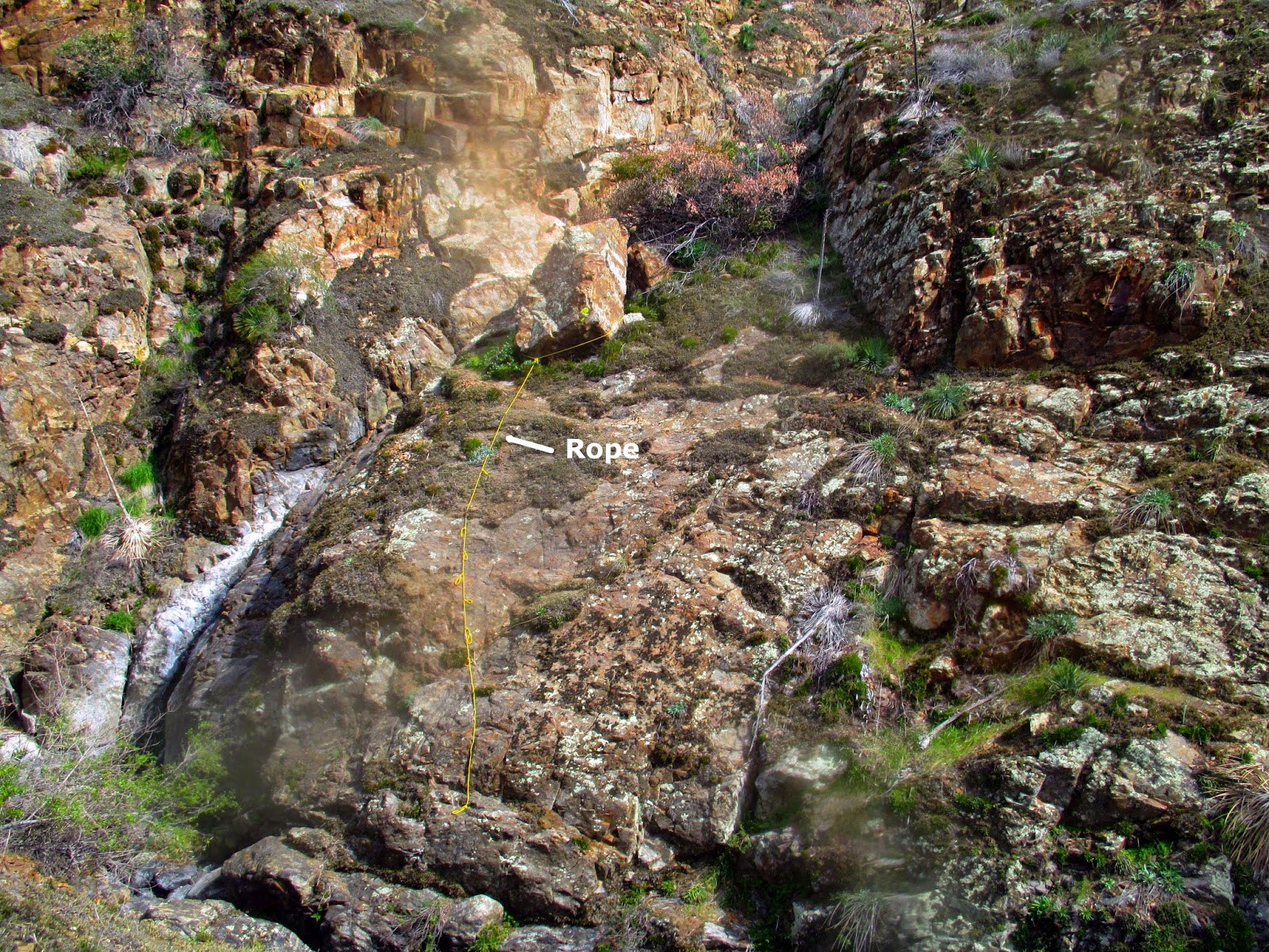
On the way back, I spotted this fixed rope on a boulder below Single Track Falls. I was not sure I could trust it, and not sure I could make it past the falls even if I made it to the boulder, so I continued up the canyon wall on the left.
Once I was back in the right canyon, I started running into large patches of poison oak, a lot of it I could not avoid. Most of the other large waterfalls I encountered had some kind of bypass on the left or right, but for some I had to force my way up the canyon wall, often with class 3 scrambling, and back down. I was now moving at a crawl, about 1/2 mile per hour. The route finding was very difficult. For each bypass I found, I thought about turning back, wondering if I could reverse my path on the return. But I kept going, hoping each new waterfall would be Tanriverdi Falls. Finally, the canyon started to clear out a little and I could sense Tanriverdi was near. It was quite a thrill to reach it, even though only a trickle was flowing over. I had to find one final bypass to get around a 20' waterfall I dubbed "Preview Falls" just before the big 160' drop. There is another drop on the bottom tier. I found the webbing left behind by the previous canyoneers around a boulder, used to make the huge rappel. I took photos, ate something, then started thinking about getting out. It had taken me 3.5 hours to reach the big falls, and I expected it to take at least as long to get out.

Tangled brush I swam through to get back to the main canyon

Sled Falls with a fixed rope

Top of Dread Lock Falls

Bottom of Dread Lock Falls. The image is blurred from debris and sweat on the lens.

Ohh Baby Pool

Had to jump across here, bypass shown on left

BJs Landing

Final 20' waterfall before Tanriverdi

Tanriverdi Falls

Webbing used by canyoneers to rappel Tanriverdi

Presenting the big falls

You know I've been to the edge, there I stood and looked down

Broken trekking pole, how I felt after the hike
I was not happy with the bushwhacking I had to do coming down, so I decided to stay in the canyon as much as possible on the way back. This meant dealing with even more poison oak, which was not growing on the walls. I am pretty sure I was slapped in the face by some poison oak vines on the way out. I scrubbed my face with cold water and Technu as soon as I got home, but time will tell if I have to cope with that. I was pleased that I found the bypasses on the way back that I had figured out on the way down. Of course, I eventually ran into some waterfalls where I had to fight up the canyon walls again, but in a decidedly different place than before. I climbed as high as I needed to feel safe before traversing across the side canyons and continued following any faint animal trail I could find. I checked my GPS to see if I had passed Gut Check Falls and saw that it was about 0.2 miles upstream.
Here is where things went sideways. At my location on the wall, the chaparral was nearly impassable. I looked for a lower animal trail and would struggle down to it only to find it quickly ended in another impassable snarl. Then, I fought up again only to be blocked. This happened several times before I got concerned. I didn't seem to have any way forward. With my energy draining quickly, I decided my only option was to get back to the canyon floor and hope I didn't cliff out. The brush was worse than the hellish mix I faced on the way down. The machete would not have been effective against the small trees I faced. I could not take useful steps so I essentially somersaulted over the top crashing into wherever I landed. The wall was steep so I had to be careful to not tumble over the edge. This was effective at getting out of the worst of it and as I neared the edge, I was lucky to find a way to down climb to the canyon floor. I thought I would have to face at least one more bypass but soon it became clear that I had emerged above Gut Check Falls and would have an easy climb out. I was quite a mess at this point, bleeding in at least 7 places. I felt bruised on all limbs and had multiple hits from yucca and random thorns. As I was almost out, I met three hikers heading down who asked me if they were almost to the waterfall. I told them there were at least 9 waterfalls, but they should stop at the second. I hope they took that advice.
This was the toughest route finding I have ever faced, the nastiest bushwhacking, and probably the most dangerous hike I've ever done. Was it worth it? Maybe, but only because I got out alive. Looking back, there are two things I would have done differently. One, I would get back in the canyon right after Single Track Falls. Two, I made a mistake staying on the wall too long on the way back. Eliminating those two mistakes would have made my life much easier. Fair warning, I still can't recommend this hike, unless you crave danger with a side of masochism. It is probably easier to rappel down many of the falls than bypass them, so come get it, canyoneers. I am done.
Update 2/26/2015: Despite my precautions, I am nursing several poison oak rashes. Both wrists where skin was exposed between my gloves and shirt sleeve, a small section on my lower back, one spot on my neck and my right ear.


See Also:
Salamander Canyon (ropewiki)
Woman Dies in Fall from Remote OC Waterfall
Montclair woman identified as rock climber fell to her death
"Strenuous and dangerous." Sounds like a good time teke. Sorry I missed it [rolls eyes].
ReplyDeleteBut congrats. You have a huge, er, machete.
Rico,
DeleteIt was a beast. The machete was counterproductive this time. I think the nightmares will go away in a week or so.
Epic. Glad you made it out. The best hikes involve real fear and involuntary somersaulting.
ReplyDeleteHey Sean,
DeleteThis hike wins on total fear. The somersaulting was a bonus. Haha.
Yesterday, 3/24
ReplyDeletehttps://youtu.be/aVgC8dgRmGc
Tim,
DeleteThat is awesome drone footage. The falls look really strong! I'm curious about where you were when it was launched. Thanks for posting it here.
Tim, please check out those rapelling down Salamander Canyon this Saturday(4/8 : https://www.meetup.com/Canyoneering-Adventures/events/237737176/?rv=me1 ) as Verdi is leading a trip on the 10'th anniversary of the first descent (4/7/2007). He's the one that the falls are named after. I would bet that the video of those rapelling with that kind of waterfall is awesome.
ReplyDeleteThree of us just did the entire Hot Springs Canyon on Saturday May 27 2017. Epic! It took us about 17 hours. Water flow was low and we did 8 repels including Tanriverdi. The slog for the final 5 hours was like dentistry without Novocaine. I'm really glad no one was seriously hurt. This place is so remote it wouldn't take more than good ankle sprain or twisted knee to require search and rescue. If you start down this thing absolutely be prepared to spend a night out there if things don't go exactly right.
ReplyDeleteUnknown,
DeleteCongrats on getting all the way through! Rapping that big fall must have been exciting. Your description of the lower part of Hot Spring Canyon matches others I've read. I'd love to link to your photos once they are posted. Feel free to come back and add a link. I doubt I'll ever attempt a full descent, but I might try the bottom half.
What is the best way to message you privately? I'd be glad to share info, pics and video but would like to discuss. Mike M.
ReplyDeletesend email to "t e k e w i n @ g m a i l . c o m"
DeleteI did the same hike as you some years ago and will agree that it was the most dangerous hikes (and most foolish things) I've ever done. The near-impossible bushwhacking, slippery rocks, cliffs and forests of poison oak make it a no-go (I think) without serious climbing gear and a skill set to match. Without exaggeration, I was not confident I would make it back out alive, but that was mainly due to a serious lack of research and preparation on my part. There's a reason why only a relative handful of people ever go in there. Beautiful but deadly.
ReplyDeleteAnonymous,
DeleteWell done getting to the falls. Not many people try (having better sense than us, haha). There have been several canyoneering trips completed in the last few years, and one that ended in tragedy. It may be getting more popular but certainly not easier.
Yeah I had been going into the upper part of the canyon for years to the first waterfalls. Then about 10 years ago I had the bright idea to walk across America, and after walking on roads for six months, I had the even brighter idea to finish the journey with a bang and hike all the way down this beautiful, empty canyon to Ortega fire station and on to the coast. No climbing gear, no skills, no problem! The key detail I forgot was the 200-foot waterfall halfway in. Literally forgot it was there. Nearly cried when I got in there and realized where I was. The prospect of retracing my steps over half a dozen gnarly traverses ("glad I don't have to come back through HERE" I thought after each one) was terrifying. If I didn't die first, I was pretty sure I was going to be the guy who ends up on the evening news dangling from the basket below the chopper with everyone watching at home going "What a moron." That was hands-down one of the dumbest things I've ever done. As you stated several times, that canyon is no joke.
DeleteUnknown,
DeleteI've heard from canyoneers that the lower half is even brushier and more tedious than the upper half. I might try a trip to the bottom of the falls from Chiquito some day, but doubt I'll even be motivated to go from the fire station. It's a beautiful canyon.
I did the entire canyon hike in June 1993 from the Ortega Hwy up the canyon to Falcon Campground. There were no ropes used and it took 5 hours. It was awesome. The falls were in full flight, with a nice jacuzzi-size pool at the top.
ReplyDeleteUnknown,
DeleteThat is a blazing fast time to get through the entire canyon, going up no less. Most canyoneers take a full day to descend it. It's a special place.
We just ran (canyoneering top-down: rappelling, wading, swimming, etc) the canyon on Feb 21st and exiting using Chiquito Springs. The flow right now is awesome! Some videos of the waterfall are on my FB page: https://www.facebook.com/willie.hunt.735 While climbing up Chiquito, it started sleeting, then snowing, and I had 4" of snow/sleet on my truck once we got back to it at Blue Jay. Anyway, my hat is off to you, as I do not even want to think about doing this canyon without ropes. Scrambling on the crumbling hill sides is WAY sketchy!
ReplyDeleteWillie,
DeleteYou are so right, that flow is insane! I'm always amazed seeing someone rappel that beast, but you guys seem very advanced. Scrambling down there was maybe not my best judgment call. Thanks for the link, I love all those canyoneering vids.
I was researching this hike and started it last weekend after heavy rainfall the prior week. What better time to see the falls (just the first 2 or 3) than after the rain. I fell in love with the area and pushed a bit further than the official trail. This place is amazing. I got about .5 mile past the usual trail end but returned Sunday and pushed even further. I did end up turning around about 20 min shy of the big falls but will return this weekend to complete it. It is interesting to read the routes taken, some are different than mine. I choose to avoid as much bushwhacking as possible and just follow the creek... which is not always possible. I do know there is no rope below single track falls, perhaps it was removed to prevent folks from going past it? It took me while to find a route to climb down but i managed. I am looking forward to going back to finish the last bit.
ReplyDeleteI will have to enjoy the falls from above, I do not intend on rep down any falls. I have not seen anyone else out there but I am not surprised. Thanks for your posts, they were helpful. as45-70@hotmail.com
Unknown,
DeleteVery cool! You are one of the few who can appreciate the difficulty and beauty on this hike. I hope the falls are flowing strongly for you. I'd be interested in any photos you take along the way.
I think about going back to the bottom of the falls every year. Maybe this year I'll get to it. Need to be ready for poison oak. There is a route that canyoneers have partially cleared from the San Juan Trail around Chiquito Spring into the canyon below the falls.
I posted some pics of my last two visits on the alltrails app. If you dont have that app i can email some if you like. my name on the app is Alf Tanner, i uploaded the pics there. You would need to search for the upper hot springs cyn trail then i have two reviews with pics.
DeleteThanks, I'll check out the photos in Alltrails.
DeleteI love waterfalls and adventures, but unfortunately, I'm massively allergic to poison oak. I was destroyed by the stuff for 9 months even with a slathering of Technu afterward. My skin is now overly sensitive to everything and I have to wear long sleeves, pants, or gaiters pretty much all the time in the fun stuff.
ReplyDeleteAnonymous,
Deleteif you are allergic to poison oak, this canyon is not for you. Even covered, it's wall to wall poison oak in a few spots and very hard to avoid. Great that you've adapted. Keep on hiking!
Its that time of year again and with the recent rains this is my favorite hike. I whent last Sunday to the bottom of liferaft falls and the flow was amazing, it appears to be very similar conditions to last year when i went which was also January. I will be going early this Saturday, i will do LPP first before dawn then by the time i get back to the parking it will be light enough to head into the canyon. They are calling for rain but it looks like its late afternoon, if its raining i will probably just do what is in my comfort zone. Given the rains lately it will all be beautful.
ReplyDeleteThanks for this "There is a route that canyoneers have partially cleared from the San Juan Trail around Chiquito Spring into the canyon below the falls" i may explore that Sunday.
Alf,
DeleteGreat time to go! I am tempted, just have to be ready to be wet all day.
The fastest way to get to Tanriverdi Falls (160 footer immediately followed by a 50 footer) is to hike the express exit (in reverse) documented here in the downloadable KML file: http://ropewiki.com/Salamander_Canyon. From the ridge as you hike down you will have an amazing view of not only Tanriverdi, but also other falls in a tributary canyon on the North side.
ReplyDeleteWillie,
DeleteThanks for posting that link. I was going to do that as a reference. I still haven't gone in through the out door, but it's on my list.
This picture may be public on FB (not sure): https://www.facebook.com/photo?fbid=10159351775265415&set=a.10151396383480415 It was taken last weekend.
DeleteThanks for that Willie, i will go check it out Sunday.
DeleteWillie looks like that rain finally arrived about 15 min after i left your group. How long did that take your group and do you stay warm in the suit for that long?
DeleteOur group was spread out on the return hike. In groups of 2, we were back at 2:20 PM, 2:40, and 3:15. We used the "Express Exit" (blue track on the KML file) from RopeWiki
DeleteI seem to have lost the trail at Rock Horn and didn't see where from there you went. Guess i am going back to have another look in a couple of weeks. Keith if you try the route, let me know... i would be interested is seeing the route. Willie... that is quite steep, can't imagine how bad the long way is to make you want to take the EE with all that gear let alone creating that trail.
DeleteAlf,
DeleteDid you try the EE route? I'll definitely create a new post if I try it, but things are iffy for the near future. Looks like about 3/4 of a mile to the falls from the confluence of the canyons.
If you want to get to the creek bottom from the rock horn, you need to traverse at roughly the same elevation until you reach a slight gully that descends to the creek bottom. No rock climbing is required, but it is very steep in places. Since we (canyoneers) are scrambling up the gully (which is obvious from the creek itself) and then traversing to the rock horn, we can see our targets along the way. Reversing it takes more exploring around to find the way down.
DeleteYes I did try the EE Sat morning at 5am but I was not successful. I found no trail or safe route once i got to what i think was the rock horn WP. That is a steep slope and i was not in the mood to look around more than i did. I am sure it was right there some place probably within 50' of me. alf tanner on alltrials if you want a look at my route. I missed the trail not looking at my nav, just assumed i was creek walking just like route to the top of the falls. I ended up down climbing on the right side of little Chaquita and was thinking this was correct. Took some effort to get back up to the ridge and find the trail. I had fun though, will go back mid Feb.
ReplyDeleteI removed my previous comment, because I see now the EE is different than the Chiquito Spring route in ropewiki. I imported the Chiquito route into CalTopo and add the leg north to Tanriverdi (0.77 mi). You got really close and great photos of the flowing falls. Here is the Chiquito map: https://caltopo.com/m/8E4KA
DeleteAlf: you went down "Little Chiquito" canyon into the technical section (like rock climbing and or rope work) at point #1 "Don't miss this turn". When we originally worked on the Express Exit, I decided to cut straight up to the ridge here, because I wanted a non-technical exit, and I wanted to minimize elevation loss for that exit. If you continued pass point #8 down the canyon you would connect (eventually) with Chiquito Spring canyon, but I suspect it needs some TLC in the brush department.
DeleteMy plan was to go down the EE and return via SJT but that did not work out and probably would have take a fair bit more time than i expected. My detour didnt help but i will check your link thanks. I am sure headed down creek from TF would be very slow... there is reason the EE is used and it is quite steep and a fitness check. Im 6 weeks past my covid holiday and i was feeling it. Probably need a couple weeks still to fully get over that... it lingers.
DeleteAhh, I see, on your way back you were thinking about going down Little Chiquito, up main Chiquito and then back up the San Juan. That would be fun :) , but a LOT longer! Also, once you drop into Hot Spring canyon from the EE rock horn, there are still 2 more rappels below that. The first one is easy enough to get around higher on the EE ridge, but the 2nd one (and final) does not seem to have any non 5 class weakness. Thus if you use the EE to hike to the Hot Spring creek itself, you will need to rappel to continue down the creek.
DeleteTLC yes to say the least. It was not passable for me at my WP 8 even in the watercourse if i wanted to get wet, it made more sense to just climb up to the ridge and get back on trail than go climb back up around little Chaquita...no thx, that approx .4 miles was really sketchy. I will avoid that at all costs, that was a one time visit. What i saw at WP 8 as far as brush had me convinced it didnt get better so up i went.
DeleteYes "TLC"! :) When I first when down Chiquito (from the Chiquito spring to Hot Springs creek), I spent hours trimming brush, cutting deadfalls, and moving debris out of the way. I would suspect that Little Chiquito is as bad or worse that that. It's will be a project, to say the least.
DeleteFrom the rock horn coming down I traversed toward TF about 100 hundred feet or so before I called it quits. Sounds like I was moving in the right direction, i just felt really unsettled on that slope. It sort of opens up at the rock horn and I felt pretty exposed. Thanks for feedback, I will go have another look soon. It should be a lot faster next time with no detours also.
DeleteKeith its not too bad just very steep and hard to find a way down after rock horn. I see pink ribbons here and there, don't recall those last time. Didn't help me much as some were buried in the dirt at my feet and i just stumbled across them. I found a way down but it was not on a trail of any sort even the return up the gully i still lost the "trail". I was surprised to see a small falls prior to the base of TF. This was a road block for me as the left side of the falls appears to be class 4, i got part of the way up and changed my mind. This is short in distance but feels like i did 20 miles... elevation gain was only 1770' if i recall. I did not see anyone on the trail until i got about 1/2 mile from the truck at just outside Bluejay. I went on Feb 11th.
DeleteAlf,
DeleteThat's great beta and matches what Willie described about the 2nd tier and what Schad described in his book on Orange County.
I'm not sure where you are going from the rock horn to reach Hot Spring creek itself, but the general direction is straight toward TF. If you traverse going only slightly downhill, you will reach the area that connects to the shallow gully that leads down to the creek right at the bottom of TF's second stage (the 50 foot waterfall just after the 160 foot waterfall). To reach the pool at the bottom of the big falls (TF) you would have to rock climb up (5th class); there is no easier way than 5th or 6th class terrain. We (canyoneers) just rappel down, as that's easy! :) Since I'm also a rock climber too, it looks easy enough to climb up on the climber's left side, but I would not try that without a rope and lead protection gear.
DeleteWillie, having gone towards TF last time and missing the way down i figured i would have a look to the left of Rock horn. It was easy getting to the gully on the left side and I felt there may be an alternate way down so i had a look. After running in to a dead end I headed back toward TF from below rock horn and that worked out. After reviewing my vid i see the left side of the lower falls may not be something in my wheelhouse. It looked climbable while on the rock about 1/4 way up but i thought about the downclimb when i got up it and went back down.
DeleteKeith,
ReplyDeleteAt first, I went to the gully on the left side of rock horn because it was very easy, then it got a bit more technical so I went right passing under rock horn and ended up finding the gully for the last portion. Lost all signs of traffic on the return just above the gully... I have yet to check my gps vs. Willies uploaded file but i will. I am sure that portion from rock horn and then back up is a bit all over the place but i call it a success even though I was not at the base of TF. I did just rewatch my video and the far-left side of "lower TF" sure appears different to me. Looking at it from the bottom Saturday i felt it was climbable, not so about that now looking at the video. Perhaps I was not seeing all of the climb from my position on the ground looking up.
And now that everyone has had so much fun with Hot Springs Canyon (Salamander) and getting to the big falls, how about this tributary? http://ropewiki.com/Axolotl_Canyon
ReplyDeleteI will be out there with a canyoneering group this Friday. Flow should be amazing!
ReplyDeleteWillie,
DeleteExciting! Please post photos somewhere. I am planning to try the Chiquito route this year, but have a few things ahead of it.
I went to the top Saturday morning; it had impressive flow still. I did notice the prior week or two ago a rope at the top of the big falls but no one there.
DeleteYes, some canyoneers got their rope stuck on pull down, and they left it. I retrieved it on Friday. BTW, if you send me an Email (willie@surefire.com) I can share a Google Photo album with the pictures & short videos from last Friday
DeleteIs this canyon always a wetsuit situation or do you just use coveralls in warmer conditions. I may have to look into getting some training, any programs in OC you can recommend? I see a few locations just curious if one if preferred.
ReplyDeleteIf you are looking for technical canyoneering training, Uber Adventures has classes in the LA area. Canyoneers normally use wetsuits, because we go in the highest flow (for this canyon anyway) and that happens in the winter and spring. Also, we get into the deep water pools which are typically 50-55F. If you go in warm weather and bypass the first deep pool, then a rain shell would be sufficient if there is significant waterflow.
DeleteWillie,
DeleteI appreciate the referral and will save it. I've taken a couple rope courses, but I'd like to learn the more advanced skills. I generally don't really like getting wet, with some exceptions, so I wouldn't make a very good canyoneer. I can still appreciate what you do.
Uber offer from basic to advanced courses. And there are many "dry" (class A) canyons in SoCal and all over the desert Southwest. Death Valley (in the winter) has amazing dry canyons to run. Utah has many too, although the most popular are swimming (class B), but not strong water flow (class C). In SoCal check out Bailey Canyon or Coyote (Left Fork) for excellent dry canyons.
Delete