Saturday, December 30, 2023

Kilauea Iki Trail and Thurston Lava Tube, HI

Hiked: 12/30/2023
Distance: 3.9 miles round trip on trail
Summit Elevation: 3498' (crater rim)
Elevation Gain: 600'
Elevation Gain (in Empire State Buildings): 0.5
Round trip time: 1 hours 50 minutes
Recommended water: 24 oz.
Parking/Fees: $30 National Parks Fee
Difficulty: Easy

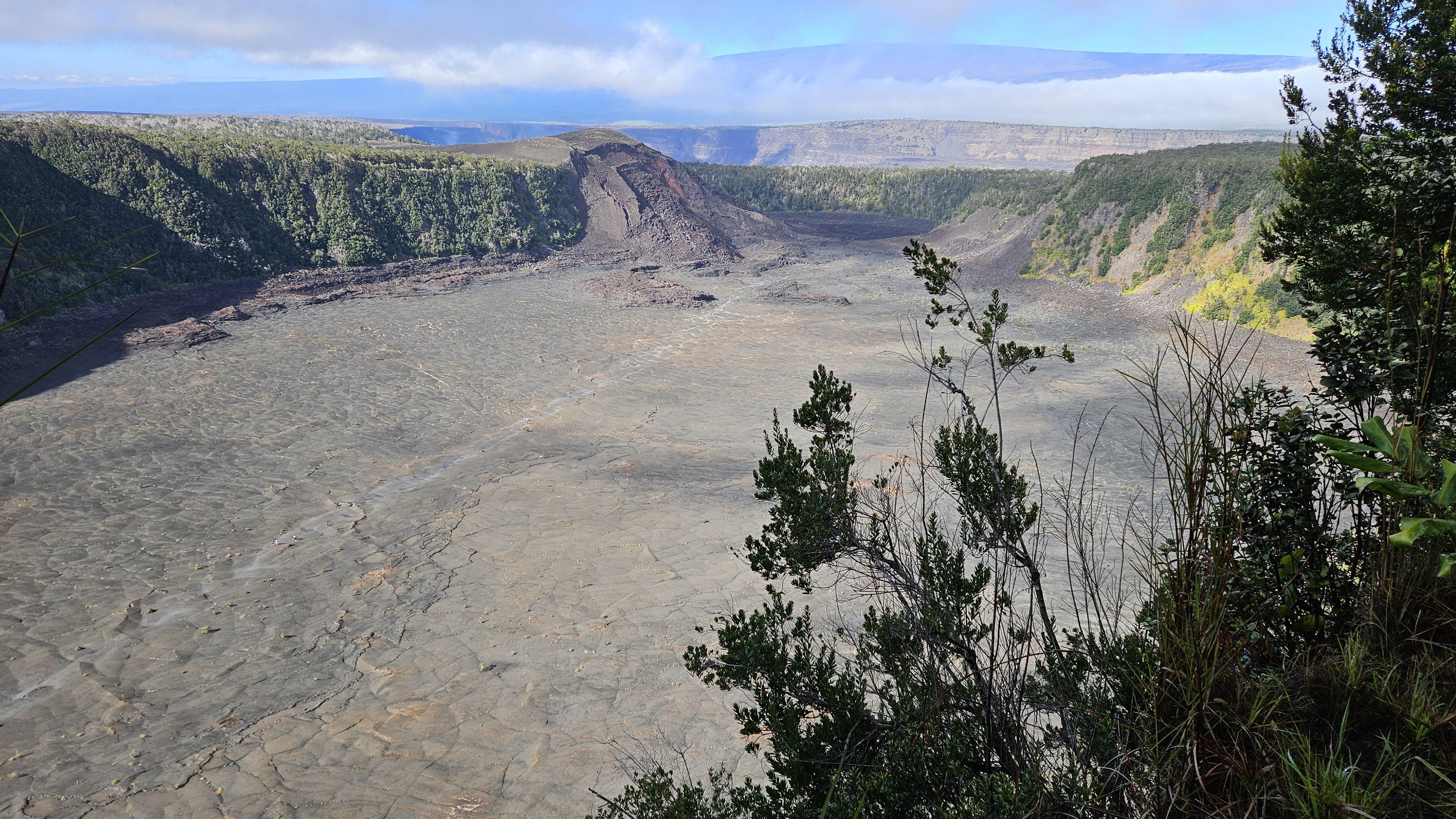
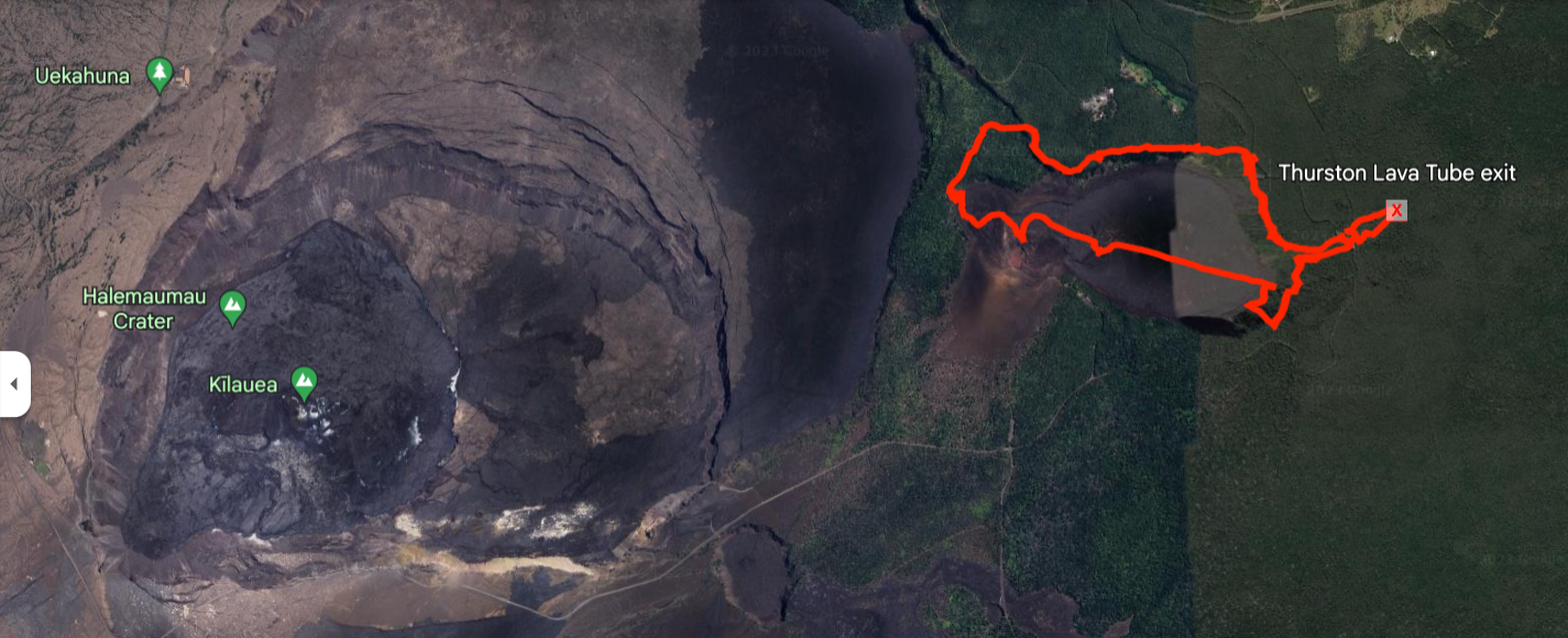
Leisa and I were back on the Big Island to ring in the new year. This was our second trip to the Big Island. We didn't make it to Volcanoes National Park the first time, so we dedicated a day to it. Our first hike was the Kilauea Iki trail. It started on the crater rim of a dormant caldera, not the active one. The trail dropped gently into the caldera, then followed large cairns of black lava rock through the center. It was unique terrain. There were a couple of steam vents along the way and I stopped to peer into one, but there wasn't much to see. At the other end, we climbed out. Back on the rim, we walked a short distance over to the Thurston Lava Tube. Dim lighting along the wall was enough that we didn't need headlamps. The lava tube was short and kind of disappointing. This was a very popular loop hike and I recommend starting early. When we finished, the parking lot was full and rangers were waving people away.


Steam vent

Exiting

Lava tube


Looking down the caldera, Mauna Loa in the background


Kilauea Hale Ma'uma'u crater

Saturday, December 9, 2023

Zzyzx Peak

Hiked: 12/1/2023
Distance: 2.8 miles round trip cross country
Summit Elevation: 2270'
Elevation Gain: 1091'
Elevation Gain (in Empire State Buildings): 0.9
Round trip time: 2 hours 15 minutes
Recommended water: 20 oz.
Parking/Fees: Free on Zzyzx Road
Difficulty: Easy

This was a bonus peak on the way home from Old Dad. I exited on Zzyzx Road southbound from I-15, crossed over the freeway and parked in a dirt turnaround. With about two hours of daylight left, I thought I could get up and down before dark. I was somewhat concerned about leaving my truck alone for two hours, but geared up and got moving. According to Wikipedia, "Curtis Howe Springer made up the name Zzyzx and gave it to the area in 1944, claiming it to be the last word in the English language. He established the Zzyzx Mineral Springs and Health Spa in 1944 at the spot, which was federal land."

The terrain was open with little vegetation. I crossed two small drainages before heading up the boulder filled gully toward a saddle in the first line of foothills. From the map, it looked like I could follow this gully to the ridge just south of the summit. However, after passing the foothills, the ridge looked like easier going. I took a sharp turn east to gain the ridge, then followed it in a semi-circle to the summit. The summit was only a mile from road as the crow flies, but 1.4 miles on my route. On top, I found a wooden post and wire that had fallen, but no marks, and no register. I had great views of the local mountains and the long, thin line of concrete that was I-15. I tagged the summit and immediately started down, racing the sun. As soon as I was back in the gully, I was in shadow, but there was still plenty of ambient light. I got back to the truck at dusk.

Credit to Tallywa for sign photo


Heading for the saddle

Moving up the gully

On the ridge, following it around to the summit

Summit with fallen post

Looking south down I-15


Saturday, December 2, 2023

Old Dad Mountain

Hiked: 12/1/2023
Distance: 5.3 miles round trip cross country
Summit Elevation: 4252'
Prominence: 1218'
Elevation Gain: 2088'
Elevation Gain (in Empire State Buildings): 1.6
Round trip time: 5 hours 30 minutes
Recommended water: 72 oz.
Parking/Fees: Free on South Powerline Road
Difficulty: Moderate

I decided to endure the long drive to the Mohave for an attempt on Old Dad (DPS #79). I wanted to get it the same year I bagged Old Woman Mountain. I left the house around 3:15 AM with a planned start around 7:30 AM. I followed the driving directions from the Desert Peaks guide from Kelbaker Road. I timed my arrival to drive the dirt road section in daylight so I could assess any danger of deep sand. The road turned out to be in good shape with only a little deep sand the last mile, easily devoured by the Tacoma 4x4.

I parked at the entrance to the wash running along the eastern side of the mountain. I followed the flat, open desert hugging the base of the mountain. Staying close made for some unnecessary ups and downs over minor gullies. I continued until I found the main ascent gully, though climbing the east face looked improbable. Once I started up, I spotted cairns that did a fine job of marking the route. The rock on Old Dad was weathered limestone. Mostly solid, though some bore sharp edges. Sharp rock ended the career of my gloves and also punctured my puffy jacket. The main route followed a series of ledges, with bits of scrambling to reach the next ledge, Chutes and Ladders style. I couldn't always spot the next ledge and got off route a few times. Off route usually meant cliffing out or making exposed class 3 course corrections. Half way up, there was a long traverse north to skirt under cliff bands, all marked with cairns. When I reached the ridge, it was an easy walk over to the summit that jutted out slightly from the mountain side like a small pyramid. I got a glimpse of either a deer or a bighorn on the west side of the summit. It ran over the edge before I could identify it. Views were impressive in all directions. The benchmark was in great shape and several registers were found in an ammo box. The oldest one went back to 1975 and was falling apart. The newest one was placed in 1994. I hung out on top for a while to absorb the desert goodness. Descent was uneventful. I highly recommend taking a GPS track as a route finding aid. Old Dad was an immensely satisfying hike, engaging with expansive views as a payoff.

Old Dad from Powerline Road

Main ascent gully, takes a hard right

Main route


Benchmark 1934


Summit


Keyholes off-route

Almost down


Sunday, November 26, 2023

Odell Benchmark

Hiked: 11/25/2023
Distance: 5.3 miles round trip on dirt road
Summit Elevation: 5220'
Prominence: 1822'
Elevation Gain: 1060'
Elevation Gain (in Empire State Buildings): 0.9
Round trip time: 1 hour 30 minutes
Recommended water: 20 oz.
Parking/Fees: Free on Telephone Road
Difficulty: Easy

My plan was to mountian bike to Magic Mountain in the western San Gabriels. I wanted to start at a road junction several miles up Indian Canyon Road. I did not know the status of the gate and found it to be closed right at the trailhead. That meant the round trip would have been around 18 miles, a much bigger affair for which I was not prepared. I drove back to highway 14 to get cell service, then looked at Peakbagger to find something easier and nearby. I settled on Odell Benchmark, only 7 miles away.

I parked at a turnout and unloaded the bike. It was 43F but I was blasted by a 25mph wind sinking the wind chill to around freezing. I expected the wind and cold weather, but it was still a shock to the system. While I was getting ready, a dirt motorbike zoomed up the road, the only other person I saw all day. I started climbing the first hill, steep but paved. I made it about half way up the hill before switching to hike-a-bike push mode. Near the top of the first hill, I got back on and pedaled past the Hauser benchmark, surrounded by barbed wire and warning signs. The road turned to dirt but was in good shape. It would have been possible to drive all the way to Odell. I enjoyed the dirt road section and got minor breaks from the wind. By then, my face and hands were fairly frozen. When I arrived at Odell, the views were decent. I found a small mark but no register. I rode the brakes hard on the way down but was nearly blown over by the wind. This was hardly a dream outing, but at least I salvaged a prominent point and worked up a lather on the bike.


Hauser Benchmark


Odell ahead

Small USGS mark


Thursday, November 16, 2023

Slot Loop

Hiked: 11/11/2023
Distance: 6 miles round trip on trail and cross country
Summit Elevation: 900' (trailhead)
Elevation Gain: 960'
Elevation Gain (in Empire State Buildings): 0.7
Round trip time: 3 hours
Recommended water: 32 oz.
Parking/Fees: $10 State Parks Fee
Difficulty: Easy

Leisa and I spent our second day hiking "The Slot" loop. The slot is a semi-famous family friendly slot canyon in AB. There are other slot canyons at the base of Travelers Peak, and dangerous canyons around the Arroyo Tapiado mud caves. My last visit here was ten years ago. At the time, parking was just a turnaround on a dirt road. Now, there was a parking lot, overflow parking, and a bathroom. Also new was a $10 day hike fee. We got started around 8 AM and passed a couple of large parties on our way through. We continued out the back and followed dirt roads toward Borrego Mountain. We left the road to get a close look at some interesting wind caves and formations. Leisa had a GPS track that looped just under Borrego then back to the parking area. However, we missed the cairns where we were supposed to climb out of the canyon and continued in the general direction of our starting point. We hit some short scrambles and narrows but I thought we could get back to the main slot. Unfortunately, we hit a 50' wall only a couple of hundred feet from the main canyon. I crawled to the top of a ridge to look over and saw no safe way forward. We had to return to where we left our track and spotted the cairns. Another short scramble and we were out of the canyons and onto a trail leading to Borrego Mountain. The summit was another half mile but we opted to return on trail to the parking area, having managed to add an extra two miles to the loop. We returned to a zoo of 40 vehicles and dozens of people milling around. Rangers were also set up to collect the day use fee as people drove up. The crowds were a drag.


Cool chock stone