Saturday, September 28, 2019

Tierra Blanca High Point, Peak 1882, Caliente BM

Hiked: 9/27/2019
Distance: 5.5 miles round trip on trail and cross country
Summit Elevation: 3089' (Tierra Blanca), 1882' (Peak 1882), 1610' (Caliente)
Elevation Gain: 2313'
Elevation Gain (in Empire State Buildings): 1.8
Round trip time: 5 hours 40 minutes
Recommended water: 88 oz.
Parking/Fees: $3 San Diego County Parks
Difficulty: Moderate

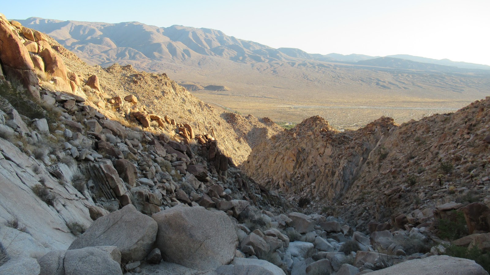
I drove to Agua Caliente County Park off highway S2 in the desert. There is a $3 day use fee (self pay). The park has flush bathrooms, camping spots, some cabins, and indoor and outdoor pools. The $3 fee includes use of the pools. I parked near the start of the Moonlight Trail, though over 90% of this hike was off trail. I noticed a lot of bighorn sheep scat around the parking area and also on the trail, but was not lucky enough to see one. After half a mile, I left the trail for an unnamed canyon to the north. The beginning had a faint use trail, but soon it was filled with large boulders. The first mile of the canyon was pretty intense with several dry falls. With route finding, I kept it at strong class 2. I started to wonder if the entire gully was going to work me this hard but some flat sandy sections appeared in the upper reaches. The higher I got, the less sheep scat I saw. I also found coyote and cougar scat. Because it had rained the day before, the animal prints in the sand were blurred. When I got to the saddle at the top of the gully, I scrambled up toward the Tierra Blanca High Point below a large rock structure.


Starting up an unnamed canyon


Went up just left of the big rock

The summit had a register in a jar inside a red can. Entries went back to 1989 and included signatures from Wes Shelberg and Paul Freiman. Views were gorgeous into the Inner Pasture and Sawtooth Mountains. The previous entry before mine was from January, 2018, twenty months earlier. After hanging out on the summit, I decided to take the ridge back. However, half way back, I dropped into another unnamed canyon to the south to finish the descent. Both the ridge and southern canyon required careful route finding and boulder hopping. On the way down, I hit two class 3 dry falls that I down climbed. As I neared the exit from the canyon, I spotted my second goal of the day, Peak 1882.


Inner Pasture and Sawtooth Mountains


Ridge in the direction of Agua Caliente


The sun was now in full force making the mid-80s temps feel a bit warmer. I switched into a short sleeved white shirt. After hours of scrambling, I was relieved to make it out of the canyon. Directly ahead was the short, steep slope to Peak 1882. At the top of 1882, I found a bare summit covered in red flying ants. I've been swarmed by both red and black flying ants. The red ones tend to bite, so I took one quick photo looking down on Agua Caliente then proceeded over the top and down the other side. Caliente Benchmark was my final goal for the day. Getting down to the trail was slow since the slope on this side was also steep and loose. Back on the loop trail, I passed through some thick green vegetation. There was a bit of flowing water on the trail. That explains the sheep hanging around this area. With a quick GPS check, I spotted where I could catch the ridge up to Caliente. On the summit was a benchmark on a pipe and a register. The 1957 benchmark was stamped by Cal B&P, which the Internet tells me is "Business & Professions", some kind of state code. The history around this mark is a mystery to me. After signing the register, I completed the loop trail back to Agua Caliente. As I got to the truck, I smelled something unusual. My guess was butane but I couldn't place it. I changed into swimming clothes and headed to one of the outdoor pools. I was there for one minute before a fireman came over and told me they were evacuating the park due to a chlorine problem. I guess too much of the chemical was put into the indoor pool. He escorted me to my truck and determined I didn't need decontamination before leaving. I missed out on a relaxing soak, but really enjoyed this fun but tough hike. One mylar balloon collected.


Peak 1882 ahead


Peak 1882 summit


Agua Caliente below


Water


Caliente Benchmark


Tierra Blanca High Point on the left


Sunday, September 15, 2019

Alto Diablo, Shields Peak, and Anderson Peak

Hiked: 9/13/2019
Distance: 16 miles round trip on trail and cross country
Summit Elevation: 10680' (Shields), 10563' (Alto Diablo), 10840' (Anderson)
Prominence: 840' (Anderson)
Elevation Gain: 4980'
Elevation Gain (in Empire State Buildings): 4.0
Round trip time: 9 hours
Recommended water: 172 oz.
Parking/Fees: Adventure Pass at Forsee Trailhead
Difficulty: Strenuous

It is my favorite time of year to visit the high peaks in the San Bernardino Mountains, avoiding the final heat waves of summer. I parked at the Forsee Creek Trailhead a few minutes before sunrise, one of four cars in the dirt lot. The road to the Forsee Trailhead is rutted, but sedans can make it driving carefully. Forsee was a new trail for me. My goal was to chip away at the 10K+ peaks in the middle spine of the long ridge leading to San Gorgonio:
  • Alto Diablo (SB 9 peaks challenge)
  • Shields Peak (HPS #9)
  • Anderson Peak (HPS #5)
I started up and quickly reached the junction with John's Meadow trail. There was plenty of greenery around the lower parts of the trail, but none of it intruding. Tall cedars and pines kept the trail cool and the light dim. Although it rose steadily, Forsee wasn't too steep. Still, the gain piled up. Around 9300', I reached an unsigned junction. The left trail continued up, the right trail was more flat. I took the right trail thinking it would wind around toward the peaks, but it was the path to Jackstraw Campground. Two streams were flowing over the trail so there was plenty of water. I looked for a trail continuation on the other side of camp until I realized the previous junction was the Forsee trail. This diversion cost me about half a mile and 30 minutes (at least no gain/loss), but it inflated the overall stats. I got back on track and pushed upward. Finally, I reached the junction below Anderson Flat and went left in the direction of Dollar Lake Saddle. So far, I had only stopped for 2 minutes to eat a GU gel. I was feeling some mild AMS effects, a little space cadet glow. I stopped at the San Bernardino Divide trail to rest with 90% of the hard work done. After some food, the AMS went away. I headed east toward Alto Diablo, taking the trail skirting the north side of Shields Peak. The trail lost a little elevation before climbing up 20' below the minor bump of Alto Diablo. On the summit, I found an ammo box with a new register. There were no benchmarks on any of the peaks. Alto Diablo had very nice views.


San Bernardino Peak


Trail junction below Anderson Peak


Summit of Alto Diablo


Looking back at Shields and Anderson

From Alto Diablo, it was only a half mile back to Shields. I had seen multiple cairns set up below it on the trail and I headed for the first one I found on the way back. Shields is a large pile of boulders and scree. It can be climbed from any direction. I went straight up from the trail on the north. The large rocks were mostly stable and small rocks were mostly not. I stuck with the large rocks, all easy class 2. The rock scramble made Shields the most fun, and the 360 views gave it the best payoff. It was definitely my favorite of the day. The summit had a fresh wooden sign and ammo box but no register. I descended at an angle down to the trail, then marched toward Anderson.


Scrambling up Shields


Summit of Shields


Anderson from Shields


I looked for a clear use trail split from the trail below Anderson, but didn't find one. I headed up through open country finding a good use trail about half way. I followed it to a small pile of boulders that formed the summit. The immediate area was surrounded by trees and had limited views. Another ammo box held a naked register. I signed it, then wrapped it in plastic baggie. At 10840', Anderson is officially 1' higher than San Jacinto, but is only the 5th highest in the San Bernardino Mountains. From Anderson, San Bernardino Peak and SB East didn't look too far, but I guessed a round trip would add about 3 more hours and tip my pleasant day hike into a grind. I packed up and started down. The Forsee trail is probably the nicest I've been on in the SB range. It's smooth as silk with few obstacles. As a science project, I decided to fill a Dasani water bottle with thin Anderson air and see what air pressure did to it down below. I took the first photo below the summit at around 10700', then another when I got home at 450' above sea level. It was crushed nicely from the sides.


San Bernardino East and San Bernardino Peak from Anderson


Dasani bottle of thin air at about 10,700'


Dasani bottle at 450'


Friday, September 6, 2019

Bighorn Mine

Hiked: 8/31/2019
Distance: 3.9 miles round trip on trail
Summit Elevation: 7044' (Mine)
Elevation Gain: 1200'
Elevation Gain (in Empire State Buildings): 0.9
Round trip time: 2 hours
Recommended water: 36 oz.
Parking/Fees: Adventure Pass at Vincent Gap
Difficulty: Easy

Leisa wanted to do a hike over Labor Day weekend, but not something too involved. We decided to check out Bighorn Mine, a popular hike on the side Mt. Baden-Powell. We arrived at Vincent Gap around 8:30 AM and the large parking lot was already 80% full. The mine trail starts behind the white gated road and drops a hundred feet or so before turning up. I guessed that most visitors were heading to the mine, but as we got down the trail, at least half were headed toward Baden-Powell. The trail starts wide, eventually shrinking to a single track. Enough bugs were buzzing that we both put on our bug nets. There was one partially washed out section of trail at a major gully, but it was not difficult to drop into the gully to get by. As we approached the mine building, we could see several parties milling around. The building was in poor repair, but large sections were standing. We took photos and enjoyed the views of Baldy, Iron #1, Ross, and the surrounding mountains. Just above the main floor was the entrance to the mine. The mine sealed years ago, but two steel bars had been completely cut in the entrance allowing easy access. We broke out our flashlights and headlamps and replaced the batteries. At first, Leisa was unsure about going in, but I talked her into going to the first junction.


Passing the washout


Bighorn Mine building


The main shaft went straight into the mountain about 150' to the first junction. It was high enough to walk without hunching except in one spot. The mine operated until 1985 and a lot of the support beams looked strong. It was refreshingly cool in the mine. Graffiti was everywhere. There were three or four other people hanging out at the first junction. From the first junction, the main shaft veers left, while the right tunnel leads down. Leisa spent a few minutes looking around, then returned to wait for me at the entrance. I went down the right tunnel until it ended quickly at a partial cave in. I was able to look around the debris to see two large drain pipes that we had seen on our way up. I returned and followed the main shaft to the 2nd major junction. There were three branch points. I took the left tunnel that led to a higher floor and a couple of large rooms that had no continuation. I felt I had seen enough of the mine for a first visit and started back before Leisa got worried. The pictures I took in the mine mostly turned out blurry. However, I did get pretty good video heading into the main shaft toward the first junction.


Leisa getting ready to enter the mine


Lower collapsed area leading to the drain pipes