Saturday, September 19, 2015

Old Sugarloaf, Peak 2040 via San Juan South

Hiked: 9/18/2015
Distance: 12.8 miles round trip on trail and use trail
Summit Elevation: 3326' (Old Sugarloaf), 2040' (Peak 2040)
Prominence: 546' (Old Sugarloaf), 350' (Peak 2040)
Elevation Gain: 3025' (combined)
Elevation Gain (in Empire State Buildings): 2.42
Round trip time: 5 hours 30 minutes
Recommended water: 96 oz.
Parking/Fees: Adventure Pass
Difficulty: Moderate

This was my second trip to Old Sugarloaf in the Santa Anas, but I started from the bottom of the San Juan Trail instead of descending from the top at Blue Jay Campground. The bottom of the trail starts on the right side of Hot Spring Canyon Road. To get there, turn onto Hot Spring Canyon Road at the fire station on Ortega Highway and continue about a mile to a large parking area. The trailhead has a restroom and trash cans.

The trail begins with short, zipper-like switchbacks for the first 300' of gain, then longer switchbacks up to the ridge line at about 1700'. At the ridge line is a junction on the right with the use trail to Peak 2040. I had found the register for 2040, which is not located at the summit, earlier in the year when I hiked up the firebreak. I followed the use trail about a half mile to bag Peak 2040 as a side trip. The trail was slightly overgrown in a few places, but easy to follow. The summit had a small cairn, but the register is quite a bit further at a lookout point above the fire station. I signed the register and saw that only one other person had signed it since my first visit in June. A large hunting knife was left near the register that was not there the first time. On the way back, I got great views of the southern Santa Ana peaks. Old Sugarloaf looked a long way out and I realized I had probably underestimated the length of my hike. While I was returning to the San Juan Trail, I heard some voices. Two mountain bikers had just passed the junction and were climbing up ahead of me. As a popular biking trail, a lot of the San Juan Trail is deeply rutted. This became an annoyance over time. I followed behind the bikers a couple of miles before they pulled away.


Bottom of the San Juan Trail


Looking up Hot Spring Canyon


Use trail to Peak 2040
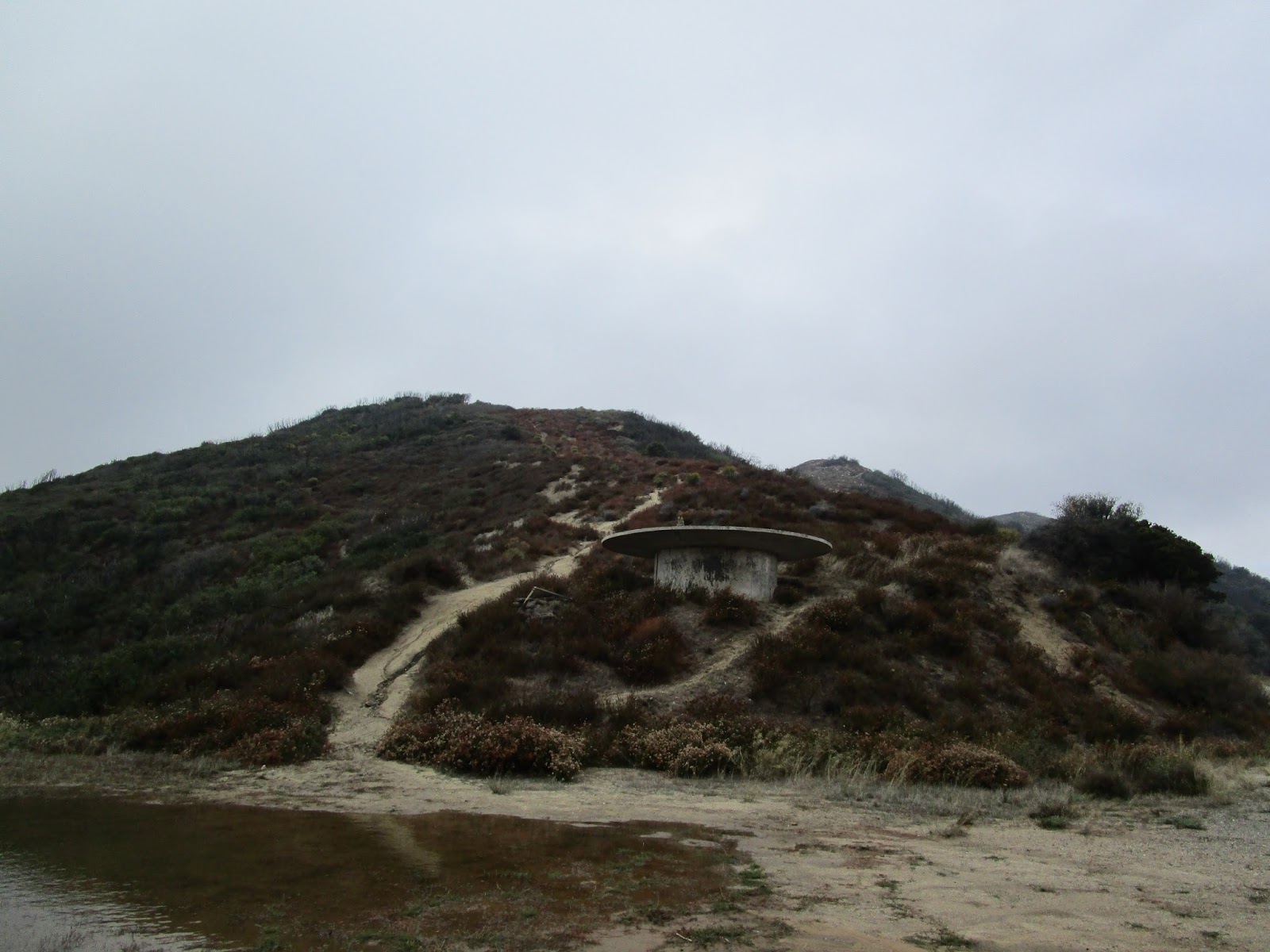

Peak 2040


Peak 2040 summit


Peak 2040 register and bonus knife at the lookout point


Old Sugarloaf and Sugarloaf from Peak 2040

The switchbacks and gentle ascent seemed to go on forever. The trail wandered toward Old Sugarloaf, then veered away, then circled back. I got a good look at Los Pinos ridge during this hike and it looked tough, something for another day. Eventually, I got to the use trail for Old Sugarloaf and made my way up. There is only one short and easy scramble near the top, though the entire trail is pretty steep. I signed the register and wandered down the north ridge a little to get a feel for the brush. It was apparent early on that this was not a better way to Tanriverdi Falls. The north ridge was very steep and utterly choked. I loitered around the summit for about 15 minutes before packing up for the return trip. The descent was hot and I had to dodge a couple more bikers flying down the trail. Otherwise, it was uneventful.


Eroded hillside, Old Sugarloaf still more than a mile away


Use trail to Old Sugarloaf, easy to miss


Old Sugarloaf from the start of the use trail


Old Sugarloaf register


Santiago Peak behind Los Pinos ridge


Looking toward RSM and Mission Viejo


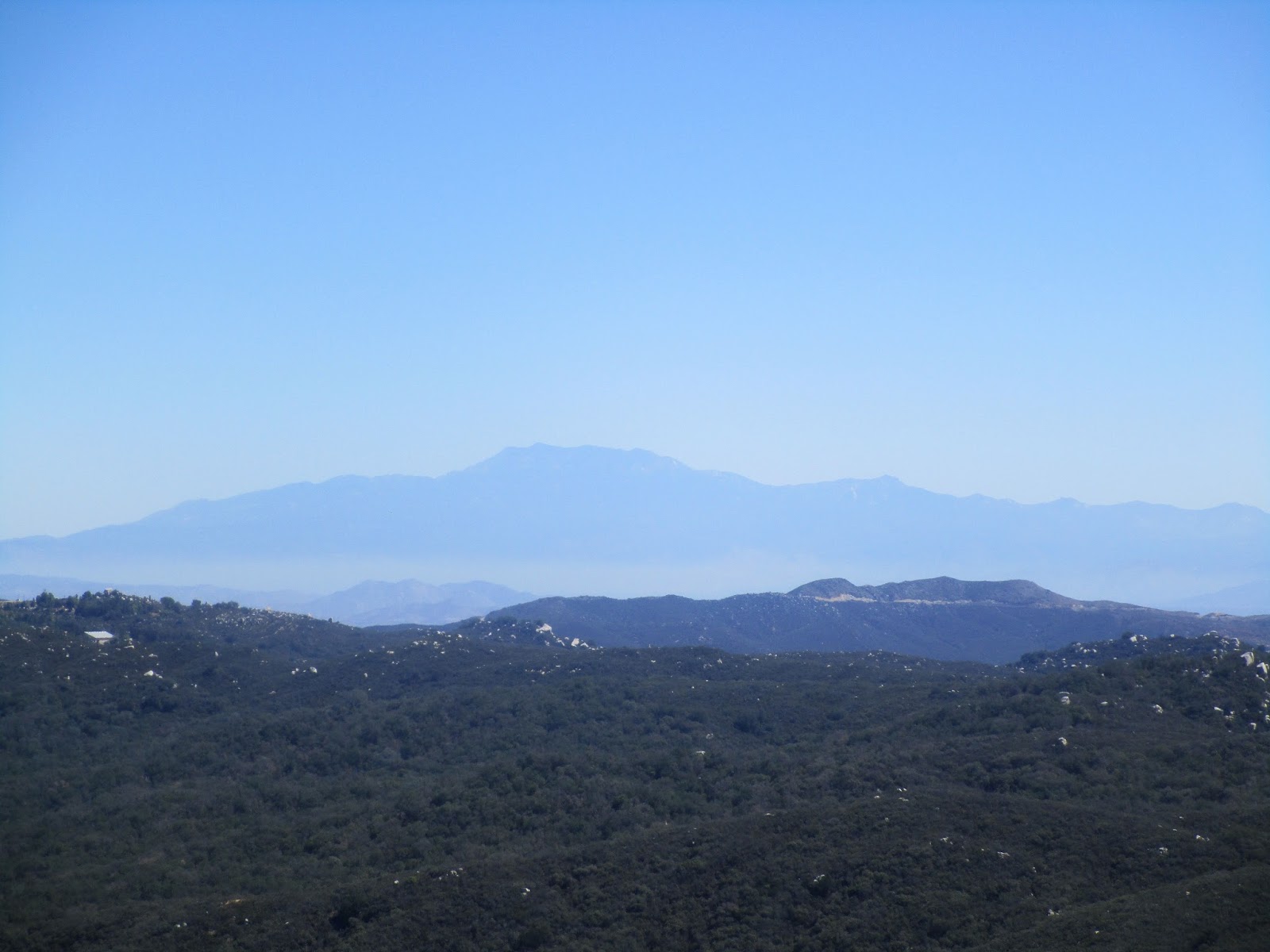
San Jacinto on the horizon


Wednesday, September 16, 2015

May Peak and Fernando 2 BM

Hiked: 9/16/2015
Distance: 1.8 miles round trip on use trail
Summit Elevation: 3948' (May), 4003' (Fernando 2)
Prominence: 328' (May), 1283' (Fernando 2)
Elevation Gain: 870' (combined)
Elevation Gain (in Empire State Buildings): 0.69
Round trip time: 1 hour
Recommended water: 16 oz.
Parking/Fees: Adventure Pass
Difficulty: Easy

May Peak is the newest mountain added to the Sierra Club Lower Peaks, in 2015 no less. I could not avoid a rush hour start time which meant spending quality time with four million of my closest friends, a million of them driving semi trucks, on the local 6-lane freeways. The adventure part of the hike was driving past downtown LA, with Google maps diverting me off and on the freeways to shave a few minutes here and there. In morning traffic, it took nearly three hours to get to the saddle between May Peak and Fernando 2 on the Santa Clarita Truck Trail (3N17). The mostly paved Santa Clarita Truck Trail is gated, and the gate was open. A sign says the gate closes at 6 PM. I would guess it opens at dawn. On the way to the trailhead, you must drive through LA County Fire Camp #9. There were a lot of cars and trucks parked at the facility, but I didn't see anyone outside as I drove through. Just past the camp, 3N17 dips down and right at a fork. The saddle is not too far after the fork and there is a wide parking area. Because of rain the day before, most of the saddle was under a shallow pool of water.

It was a surprisingly cool 55F under low, lingering clouds from the passing storm. I started up the damp firebreak, only muddy in places, for the short hike to May. It was about a mile round trip over a use trail and some false summits. Clouds blocked the views, so I focused on getting to the summit and signing the register. The register started in 2015, yet was already half full. The newest lower peak was quite popular. I concluded my business and jogged most of the way back, passing three other hikers on the way up from the saddle.

As soon as I was down, I headed up the firebreak toward Fernando 2. Fernando sports a healthy prominence of 1283' and the top was buried in the clouds. When I got to the top, I started looking around for the benchmark, expecting it on this side of the summit based on the topo maps. It was not hard to locate and was stamped "Camp 9". I am not sure about the origin of the Fernando 2 name. Still in the clouds, there was not much to see. I wandered around past the benchmark and found several fenced buildings and a lot of equipment. This location was one of the former Nike missile sites. It is still being used for something, though the missiles are long gone.


Gate on Santa Clarita Truck Trail (3N17)


Passing through the fire camp


Firebreak and bumps leading to May Peak (not visible)


Windbreak on one of the bumps


May Peak ahead


Register


Returning to the saddle and looking at the firebreak leading to Fernando 2 in the clouds


1983 benchmark stamped "Camp 9"


One of the fenced buildings with storage tanks


Friday, September 4, 2015

Stag BM

Hiked: 9/4/2015
Distance: 9 miles round trip on trail and cross country
Summit Elevation: 2272'
Elevation Gain: 2080'
Elevation Gain (in Empire State Buildings): 1.66
Round trip time: 5 hours
Recommended water: 80 oz.
Parking/Fees: Adventure Pass plus OC Parks $3/$5 on weekends
Difficulty: Moderate

Looking around the topo map for the Santa Ana Mountains, Stag benchmark caught my attention. It is north of the San Juan Fire Station (Ortega Highway) between Cold Spring Canyon and Crow Canyon. It seemed an odd place for a benchmark, since there is a slightly higher hill close by. Some research help by Pat on the San Gabriel Forum unearthed a National Geodetic Survey datasheet of the benchmark last updated in 1986. In addition to the benchmark, two reference marks were mentioned in the datasheet. I could not find any trip reports or beta on it anywhere else and decided an exploratory hunt was in order. It is possible this benchmark has not been visited in 30 or more years.

The nearest trail to Stag is the Los Pinos Ridge Trail, but getting there from the trail would involve crossing a very steep, nasty, and likely poison oak filled section of Cold Spring Canyon. The NGS survey suggested approaching on a dirt road from Ortega Highway followed by some cross country travel on firebreaks. I plotted a route close to that starting at the fire station off Ortega Highway. There are two possible fees involved with this route. The one public parking spot at the fire station requires an Adventure Pass (presumably), then you enter Caspers Wilderness Park, a county park with a day use fee, then head north into the Cleveland National Forest to hit Stag. We started up Hot Spring Canyon Road, then quickly turned left down Sievers Canyon Road. This road is in Caspers Wilderness Park and we paid the day use fee, though the signs at the northern border discourage entry at that point. There is a picnic area just past the gate. A short distance down the road, we ran into several mule deer. Before we got to Cold Springs Trail junction, we saw a lone stag cross the road (aces!), but it bounded away before I got a photo. We followed Cold Springs Trail through a shaded area, crossed a dry creek, then ran into another group of mule deer.


Caspers Wilderness Park and Sievers Canyon Road


Mule deer


Junction with Cold Springs Trail

On the trail, we found a tarantula hawk wasp. I had seen many in my travels but this was the first one I was able to photograph. We continued up the switchbacks until it met the Oso Trail. A right turn at Oso Trail junction got us deeper into Caspers Wilderness Park. The next junction was not signed, but our track had us make another right turn and continue north. Then we ran into a gate that separated the park from Audubon property. From what I had read, public access is allowed on Audubon property as long you stay on a trail. Probably less than a half mile of the trail passes through the Audubon bird sanctuary so we figured we were OK to continue. We quickly got back into the Cleveland National Forest and reached the northern most point on the trail. From there, we started weaving our way through brush toward Stag.


Tarantula hawk


First glimpse of Stag BM

Before leaving the trail for the 0.6 mile one-way thrash, I stopped to put on knee high gaiters to reduce the damage to my legs. There were reasonably good animal trails heading up the first bump, down to a saddle, and up to the second bump (peak 2213). Near the top of the second bump, we found an overgrown firebreak and followed that down to the saddle with Stag. Then, everything got thick with no clear path forward. I stopped again and put on a long sleeved top, got out the clippers and handed them to Noel who was in the lead at the moment. Noel clipped some brush and we pushed through slowly until the clippers broke on a beefy branch. We briefly considered turning back but were less than a quarter mile from the top. We steeled ourselves and started bashing through. Fortunately, the firebreak reappeared and the brush got a little thinner. It was still light to moderate bushwhacking, but the heaviest stuff was behind us. I thought I had entered the coordinates of the benchmark in my GPS, but when I checked, it wasn't there. We forged ahead to the high point and scoured the area but could not locate the actual benchmark or any reference marks. I had hauled up a green register box, a register and a couple of pencils. We signed the register and placed the box at the summit of Stag BM. The bushwhacking had left us looking filthy. There were good views in a few directions and brush blocking the view in other directions. There was a sense of satisfaction getting to the top, even if we didn't find the benchmark. On the way back, we went down the ridge of the peak 2213 all the way to where it nearly met the trail. Then, we crashed through another thick section of brush and small trees. With enough searching, we might have found a better way out. On the way back, we ran into the same two groups of deer in about the same areas, but didn't spot the stag a second time. We were both pleasantly surprised that we encountered no ticks or snakes the entire trip. If you make this trip and sign the register, please let me know by email or comment. I'd be interested in the route you took and if you located the benchmark.


Noel off trail


Path to Stag


Looking up at Stag from the saddle


Plastic stag in the register


Noel signing the register, and a woodrat nest (we saw several along the way)


Filthy animal signing the register


Register final resting spot


View back toward the OC


Santiago Peak from Stag BM


Noel busting out of nasty chaparral on the way back to the trail


This is how I end up breaking a lot of cameras