Friday, October 30, 2015

Box Springs Mountain and Table BM

Hiked: 10/30/2015
Distance: 6.7 miles on trail
Summit Elevation: 3080' (Box Springs), 2559' (Table BM)
Prominence: 1160' (Box Springs), 309' (Table BM)
Elevation Gain: 1300'
Elevation Gain (in Empire State Buildings): 1.04
Round trip time: 2 hours 20 minutes
Recommended water: 40 oz.
Parking/Fees: $5 Riverside County Parks
Difficulty: Easy

Box Springs Mountain separates Riverside from Moreno Valley and rises prominently along highway 60 in the Inland Empire. On the east side of the mountain is a giant white "M", a symbol for Moreno Valley, and on the west side is a giant yellow-orange "C", a symbol for UC Riverside. Both can be seen from the highway, but the C is only visible briefly. The park is managed by the County of Riverside. Here is a trail map. I chose to start at the main parking lot on the Moreno Valley side. To get there, take highway 60 east from Riverside, take the Pigeon Pass Road exit and turn left (north), then follow it west until it turns into Box Springs Mountain Road and curves back west. Continue past where it turns into a dirt road and ends at the day use dirt parking lot. The dirt road is mellow and any car should be able to make it to the parking lot. There is a $5 parking fee with a single pay slot at the entrance to the lot, no envelopes, no credit cards, and it appears to be on the honor system (you can't get a parking receipt to prove you paid). There is a portable toilet at the lot and a few picnic tables. To avoid the fee, there are several free access trails to the mountain, including the Two Trees Trail and the M Trail.

From the parking lot, I started south past a gate along the wide Box Springs Mountain Road. From the start, you can spot some clusters of radio towers along the ridge. The first couple of clusters are not the high point. As I was catching up to a couple heading the same way, I saw them stop and start to take pictures of the road. When I got there, I saw it was a Western Patch-Nosed snake having a large lizard breakfast. She may have bitten off more than she could chew. I took a photo, then continued past them to the radio cluster at the high point. The wind was blowing like crazy, kicking dirt in my face and knocking me sideways. I turned my hat backward to try to keep it from blowing away. I hunted for a benchmark at the top of Box Springs Mountain, but found nothing but some graffiti. Eventually, I gave up on the benchmark and continued past the high point to the end of the ridge to get a close up view of the giant "M". I jogged most of the way back to the parking lot, passing a few hikers and one biker to get ready for the second part of the hike. The round trip for this segment was 5 miles and took about 75 minutes.


Box Springs Mountain from highway 60 with the big white "M" visible


At the trailhead, towers along the ridge in the distance


Lizard for breakfast


Box Springs Mountain high point


Summit towers


Big "M" painted on the mountain


East side of the Santa Ana Mountains from Box Springs Mountain

Table BM looked fairly close to the parking lot, but in the opposite direction of Box Springs Mountain. I could see a trail heading in that direction from the road, so I took it. The unsigned trail aimed straight for the summit. Along the way were many boulders, most with graffiti. It's a sad reality, but not unexpected for a mountain in the middle of Inland Empire sprawl. The high point was a large class 2 block and it looked like the benchmark had been dug out of the soft sandstone. Someone carved a heart into the top. I went over the summit block and onto a table-like boulder, also decorated with graffiti. Back on the summit, I noticed what looked like a marker on the top of a nearby boulder. The boulder with the benchmark was about 10' with an 8" vertical crack. I tried the crack a couple of times without luck, then found a different class 3 way up using sloper holds a little to the left. After getting down, I tried the crack again, finding that a foot jam was all I needed to get started. I ended up climbing the crack twice. The intact benchmark on the boulder was a reference mark pointing to the high point with the missing benchmark. I hit a couple of other boulders on the way back that proved to be easier. It was a short, but fine morning of urban hiking.


Table BM from the parking lot


The table namesake boulder?


Graffiti on the table


Looking over the edge of the table


Summit block


Heart shaped carving on the summit


Nearby boulder with the reference mark, I climbed up on the left first, then up the crack


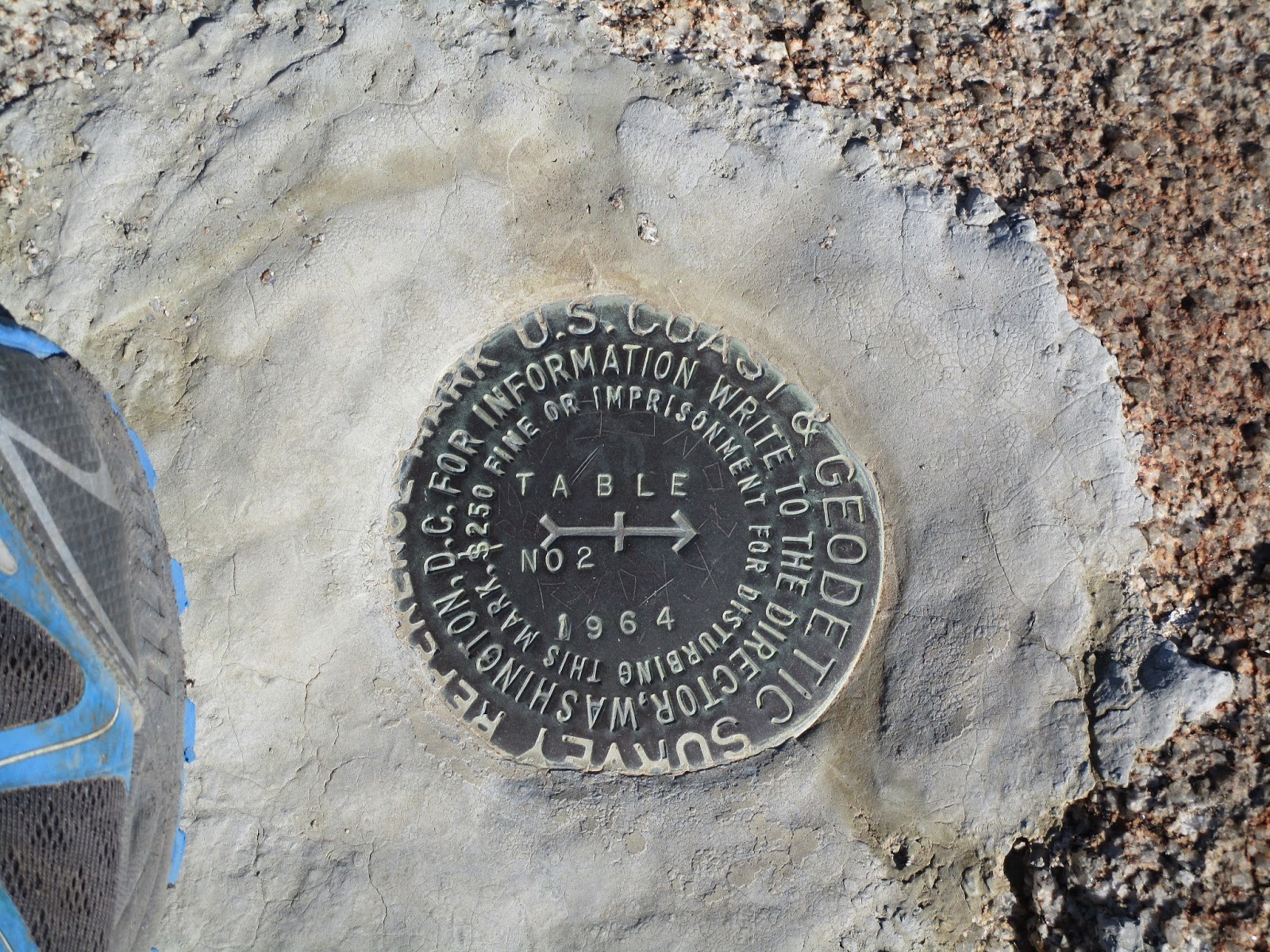
Table Reference Mark #2 on top of the boulder,
probably still intact because it's not as easy to climb as the true summit

Table BM Photosphere


Friday, October 23, 2015

Slide Mountain Lookout

Hiked: 10/23/2015
Distance: 9 miles on trail and use trail
Summit Elevation: 4631'
Prominence: 631'
Elevation Gain: 2800'
Elevation Gain (in Empire State Buildings): 2.24
Round trip time: 3 hours 30 minutes
Recommended water: 72 oz.
Parking/Fees: Adventure Pass
Difficulty: Moderate

Some of the mountains on the Lower Peaks list are far north of Los Angeles. Living in south Orange County, that means there is an ocean of cars between me and those mountains. The tides of that ocean play havoc with the logistics of day hiking those peaks. Low tide on the L.A. freeways is generally between 8:30 PM and 5:30 AM, meaning I need to get north of the city before 5:30 AM or spend 2-3 additional hours sitting in traffic. That long introduction was to explain why I started the Slide Mountain hike in the dark, and why many hikes of distant peaks start in the dark. Logistics.

The trailhead starts near Frenchman's Flat Campground, where old highway 99 is blocked. Parts of highway 99 were replaced by I-5. The southern terminus of highway 99 is now at Wheeler Ridge. This is a rare hike that starts in the Angeles National Forest and ends in the Los Padres National Forest. The main route heads about 1.5 miles up the abandoned highway, then turns left onto the Slide Peak trail. There was one other vehicle parked at the trailhead when I arrived, but it appeared lifeless. I took off around 6:00 AM, about an hour before sunrise. I could hear, but not see, Piru creek flowing below me on the right side. When I got to the Slide Mountain trail, it was still dark. The trail started out wide, but eventually narrowed to a single track. As the sun rose, I could finally see the stratified geology of the area and Pyramid Lake below. The sun played some interesting tricks on the rocks.


Starting in blackness


First look at Slide Mountain near dawn


Here comes the sun


Slide Mountain from the saddle


Lighting trick on these cobbled boulders

At the saddle, the trail turned right and there were a few switchbacks on the right side before the trail curled around left of the summit. I didn't see the lookout tower until I was very near the top. The tower is not very high, but it doesn't have to be at that vantage point. The stairs were not locked so I could walk around the top of the tower and take in the excellent views of Los Padres. I was impressed with this angle on Cobblestone. The benchmark is intact, and the register sits just below a more formal sign in sheet for hikers. I put my signature to both. Under the tower I found a chest labelled WATER and indeed there were half a dozen bottles of water inside. A sign on the tower indicated they were looking for hikers to volunteer as lookouts. There is also a portable restroom at the top. Everything looked well maintained.


Slide Mountain Lookout Tower


Pyramid Lake


Register. Since this is Los Padres, I was not surprised to find David Stillman.


Inside the lookout


Benchmark


Mountains around Cobblestone

Instead of returning along the trail, I headed over to Peak 4618, then cross country down to the trail. The vegetation was a little thicker than expected so I may not have saved much time. Back on the trail, I jogged down to the saddle. From there, I struck out along the firebreak, planning to take the ridge back. This was far more interesting than returning on the trail. The firebreaks and use trail were usually easy to follow, but there were a few places where they faded out. 1400' of descent came in the last mile and was sharply steep in places. I had to hunt around to find a way to descend from the final bump without going a half mile out of my way down a more gentle slope. The last obstacle was getting over Piru Creek, which left my feet wet for the drive to Saddleback Butte. I hardly thought about my feet, though, having enjoyed Slide Mountain from start to finish.


Returning along the ridge


Heading up to Peak 3900


Almost down


Crossing Piru Creek


Slide Mountain Photosphere


Would you like to know more...?

Saddleback Butte

Hiked: 10/23/2015
Distance: 1.7 miles cross country
Summit Elevation: 3651'
Prominence: 716'
Elevation Gain: 720'
Elevation Gain (in Empire State Buildings): 0.57
Round trip time: 1 hour
Recommended water: 20 oz.
Parking/Fees: $6 California State Parks
Difficulty: Easy

Saddleback Butte is one of several high desert buttes in the Antelope Valley and #38 on the Lower Peaks list. This was my second summit of the day, after climbing Slide Mountain. I set my navigation for Saddleback State Park, but instead of taking me to the campground entrance, it took me to the park fence on a dirt road on the east side of the mountain on 190th St E. The dirt roads were mild, not requiring high clearance. There are no trails on the side where I parked, but the open desert here was easy so I just headed straight for the summit. It was hard to tell how difficult the boulders were going to be but it turned out to be nothing but class 2. On the way up, I spotted something white and man made on the side of the mountain. My first thought was it must be some kind of science experiment, but in fact, it was a crashed drone. The landing gear had come off and the door to the battery compartment as well. It was upside down so I flipped it over to see if it was salvageable. The damage did not look that serious, but I didn't feel like dragging it all the way back. If anyone wants an abandoned drone, I marked the location on my GPS at (34.674963, -117.797466). I continued up to the summit and found the benchmark and two reference marks. No register. The views were good in all directions and I could make out the north ridge of the San Gabriels. From the north, Baden-Powell looks like the alpha. After a brief stay, I descended to the saddle, then down a gully and out. Having driven up I-5 past highway 14, then back along 14, then home along highway 138 and I-15, I completely lassoed the San Gabriel range with my car. It was a strange side effect of doing Slide Mountain and Saddleback Butte the same day.


Saddleback Butte on the right, the south summit is slightly lower


Heading directly for the summit


Crashed drone a little more than half way up


Drone right side up


Final push


Benchmark dated 1929


San Gabriel ridge from the north


Friday, October 16, 2015

Los Pinos via Bell Ridge

Hiked: 10/16/2015
Distance: 13.5 miles on trail
Summit Elevation: 4510'
Prominence: 610'
Elevation Gain: 4070'
Elevation Gain (in Empire State Buildings): 3.25
Round trip time: 6 hours 10 minutes
Recommended water: 144 oz.
Parking/Fees: Free on Robinson Ranch Road
Difficulty: Strenuous

This was my second visit to Los Pinos Peak in the Santa Ana Mountains. The normal route is relatively short, leaving from Blue Jay Campground. I was aware of the Bell Ridge trail coming down from Los Pinos, but only recently learned from Scott Richardson that the trail went all the way to Rancho Santa Margarita. Thanks! Bell Ridge was a section of the Santa Anas I had not seen. The Bell View Trail starts on Robinson Ranch Road just past Vista Road and runs the entire length of the ridge. You can park on the side of the road for free. The previous weekend, I had done a short scouting hike on the trail up to an unnamed peak at 2537' where an American flag stands on a pole. The task ahead was to tackle the entire ridge.

After a couple of switchbacks, a use trail shortcut near a sign takes off to the right. It merges back with the Bell View trail in a mile or so. I took the shortcut going up and coming down. There was no benchmark at the flag pole summit, but it looks like there used to be some kind of wooden post or sign set in cement. I was looking forward to maybe the best views in the entire range with Trabuco Canyon on one side and Bell Canyon on the other. It was promising based on my scouting mission. But on this day, the cloud cover was low and the entire sky overcast as a low pressure system moved through the area. This made the hike much cooler by blocking the sun, but it also killed views in every direction. I resigned myself to the fate of the weather gods and continued up to a T-junction. The main trail goes left, the right trail goes to a lookout point.


Trailhead


Shortcut trail on the right


Flag pole summit, clouds blocking the view


Rolling ridge


Temporary glimpse of Santiago through the clouds

I thought I would be alone on the ridge all the way, but I caught up with another hiker and his dog a little more than 3 miles from the start. He had come up from Trabuco Road and had no particular destination in mind. Like me, he was drenched from the humidity, wet plants, and sweat. I wished him well and moved on, hitting a long stretch of gain taking me to 3500'. The clouds were still thick and moving north, but once in a while, I got glimpses of the bumps and peaks surrounding me. I got a look at peak 3789 ahead of me and it was impressive. There is a bypass trail that runs around the south side if you don't want to climb it. I took the bypass on the way out and went over it on the way back. I found a fire ring on top with ashes but the summit didn't look big enough to set up camp. As I moved past peak 3789, it started to rain. Lightly, at first, then steadily. I stopped to put on a poncho, not to keep me from getting wet, but to keep my camera and phone from getting wet. It rained for about 30 minutes, increasing the humidity another notch before I put the poncho away.


Peak 3789, the second bump ahead


Starting up Peak 3789


Fire ring on the summit of Peak 3789


Section on the north side of 3789

The next bump took me over 4000' and a little past the top I found the use trail heading down to Yaeger (Caltopo spelling) Mesa. The series of bumps continued along the ridge dropping me well below 4000' before the final push to Los Pinos. It was a relief to hit the Los Pinos ridge, turn right, and walk the short distance to the summit. I did my usual rituals and cursed the clouds for blocking my just rewards. On the way back, the clouds started to burn off just a little. I got a slightly better idea of what the ridge looked like. At around 3460', there was a minor bump with a nice outcrop of boulders just off the trail. I stopped to scramble up and take a few pictures of Trabuco Canyon. The rest of the descent was uneventful. I saw almost no wild life and was not surprised. Most of the animals were taking the day off.


Junction of Bell Ridge trail (right) with Los Pinos summit trail


Los Pinos summit with new, hand crafted sign


Obligatory


Outcrop at bump 3460', easy class 2 scramble


Trabuco Canyon and Holy Jim trailhead area from the outcrop


See also:
Los Pinos from Main Divide
Los Pinos via Los Pinos Ridge