Distance: 13.3 miles round trip cross country and use trail
Summit Elevation: 2601' (Piedras Grandes), 2716' (Puff), 2939' (Moan), 2280' (Indian Hill)
Prominence: 241' (Piedras Grandes), Unknown (Puff), Unknown (Moan), 120' (Indian Hill)
Elevation Gain: 3520'
Elevation Gain (in Empire State Buildings): 2.81
Round trip time: 10 hours
Recommended water: 164 oz.
Parking/Fees: Free near Dos Cabezas Road
Difficulty: Strenuous
Goat Canyon Trestle is one of the largest wooden train bridges in the world, and is sort of the San Diego county "bridge to nowhere" with some notable exceptions. One is that the private company that owns the rail line plans to put it back in service in the near future. Spanning 600' across Goat Canyon, it is a worthy destination by itself in the southern Anza-Borrego desert and Jacumba mountains. The hike planned would cross four San Diego Sierra Club peaks, with a side trip down Goat Canyon to the trestle, and possible side trip to a Native American petroglyph cave. A California Gold episode with Huell Howser on the railroad and trestle is available free here.
Sean and I met at Laguna Hills Mall parking lot at 4 AM and carpooled the nearly 3 hour one way trip to Mortero Wash. The turn off for Mortero Wash is just past the Border Patrol checkpoint on S2. I parked about 0.4 miles from my planned parking spot on Dos Cabezas road. There was a very rough part of the road that I didn't feel comfortable driving over in my low clearance sedan. That added distance and time to an already ambitious hike. We got under way just after 7 AM with Piedras Grandes the first target. The wind was blasting us from the start, with estimated gusts of 40-50 mph.
We started out on a faint road, then headed into the desert around the first rock pile. Sean wanted a direct assault on Piedras Grandes, while I wanted to come up the ridge further to the right. We agreed to meet at the top. He ran into dead ends and met me at the top about 10 minutes after I arrived. The register was newly replaced, but there was no pen or pencil to sign it and neither of us had one in our pack so it went unsigned. The wind had nearly blown my hat off on the way up so I stuffed it in my pack until it died down. It also had a chilling effect and kept my layers on, despite being around 60F. We wanted to get out of the wind and were soon off to Goat Canyon descending the south side of Piedras Grandes.

Sunrise

Water tank at Dos Cabezas

Piedras Grandes

View down from Piedras Grandes summit

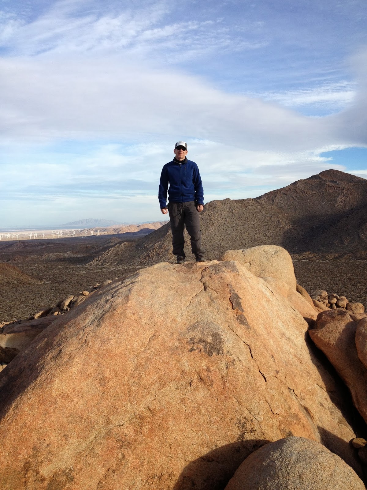
Sean on Piedras Grandes

Descending the south side of Piedras Grandes
We did a lot of bouldering and side hill work to finally reach Goat Canyon. Once we found the main trail, it was in good shape and easy to follow. The trail mostly followed the right side of the canyon, sometimes dipping in and out. It climbs to around 3300', then quickly loses about 1100' as you approach the Goat Canyon Trestle. The first good view of the trestle comes at the end of the official trail at the top of a steep dry waterfall. There didn't appear to be an easy way down. We back tracked a little, then traversed right along a loose gravelly slope until we found a steep gully where we slid down one at a time. From the bottom of the waterfall, you veer to the right toward a dirt road and the trestle with a couple of abandoned rail cars. The trestle had some spots of soft rotten wood, but also some new steel grating and signs of repair. We crossed it to explore tunnel #15 on the other side and get different views of the amazing wooden structure. After some photos, we took our first break and ate lunch on a pile of railroad ties. I enjoyed some Bumblebee Spicy Thai Chili Tuna. The hike had already roughed us up a little leaving cactus needles deep in our legs and feet. The biggest danger were the baby cholla, balls of spikes lying nearly everywhere. A few that penetrated my shoe were in so deep I had to use tweezers to remove them. Sean's legs were bloodied and he lost his sunglasses and his camera case somewhere before the trestle.

Goat Canyon trail

First view of Goat Canyon Trestle

Goat Canyon final descent

Looking back at Goat Canyon, descent gully on the left

Almost there

Collapsed train tunnel (old #15)

Trestle panorama

Trestle side view

Here's Johnny!

On the trestle

Looking over the right side

Train tunnel #15

Goat Canyon Trestle from the other side

Looking up Goat Canyon from the trestle

Bumblebee Spicy Thai Chili Tuna. Nom nom.

Cholla attacks me

Cholla attacks Sean
The next stop was Puff BM rising directly over the trestle. We followed the tracks around to find the best place to start up the ridge. That ended up being the very end of it. There was a very faint use trail up the ridge to Puff BM and a birds eye view of the trestle. There was no register. Next, we tried to determine the best way to head toward Moan BM. Two other trip reports I had read suggested to side hill around in that direction. It looked difficult and slow, and it was. Sean led this section, following goat trails where possible. There was goat scat everywhere in the mountains, some fresh, but we never saw a goat. When the GPS said Moan BM was near, I led us up the wrong rocky summit, then made some corrections, and led us up another wrong summit. Sean consulted his GPS and between us, we agreed on the next likely candidate, a less prominent peak along a ridge. What stood in our way were piles of car sized boulders. We picked our way across hoping nothing fell into one of the deep wedges between them, including us. When we got to Moan BM, it was clear that the approach we took from the south was more difficult than the east. Moan BM had a register with a pencil, so we recorded our trek to that point, and took our second break.

Approaching Puff

Puff BM

Goat Canyon Trestle from Puff BM

Side hilling toward Moan BM

Damn baby cholla

One of three peaks I mistakenly thought was Moan BM

Giant boulder hopping

Moan BM

Looking northwest from Moan, at Sombrero Peak (I think)
It was starting to get late in the afternoon, and we didn't have time to explore the petroglyph cave, so we headed for Indian Hill. It was another boulderfest descending toward Indian Hill, but not the giant boulders we hit on the other side of Moan. The San Diego Sierra Club list has Indian Hill as a class 3 climb. It was an easy class 3, if that. Indian Hill had a register, but no benchmark that we found. We descended on the north side and followed the road, then the train tracks back to the car. We got back as the light was fading, bruised and punctured, but four peaks richer for the experience. We didn't see any other people all day. Thanks to Mike Sullivan for valuable beta on the area.

Heading toward Indian Hill, the taller hill center left

Climbing Indian Hill

Indian Hill register with nice painted rock inside
Standing on top of Indian Hill

Following the tracks home


Would you like to know more...?
So jealous, this is a trip I originally wanted to do, but didn't allow enough time. Looks like we wear the same shoes! Color and all. Love those things.
ReplyDeleteHey Derek,
DeleteThe Vasque Mindbenders have been very comfortable and easy on the feet, better without the cactus needles ;) It was a tough day that left me sore all over, but in a good way. Boulder heaven, especially between Puff and Moan.
This is an easy mountain bike ride from the Dos Cabezas area. The grade up is very slight and so the ride to the bridge is pretty easy going with constant pedaling. Some of the entries to the tunnels are caved in, but you can carry your bike over the rocky hills. The best part is the ride back as the slight grade down allows you to coast the entire way back.
ReplyDeleteBoyfester,
DeleteI know many people bike or even motorbike it. We wanted to pick up the peaks on the way out and back. That bridge is an amazing structure buried in the desert. I've heard that police or railroad security sometimes patrol the tracks, but I don't know if that is true or a legend.