Sunday, March 20, 2016

Cathedral Peak, La Cumbre Peak, Arlington Peak

Hiked: 3/18/2016
Distance: 3 miles round trip on trail and use trail
Summit Elevation: 3985' (La Cumbre), 3333' (Cathedral), 3250' (Arlington)
Prominence: 1010' (La Cumbre), 383' (Cathedral)
Elevation Gain: 1800'
Elevation Gain (in Empire State Buildings): 1.44
Round trip time: 3 hours
Recommended water: 56 oz.
Parking/Fees: Free on Camino Cielo
Difficulty: Moderate

After the short hike to Montecito Peak, I parked below La Cumbre Peak (translation: the top) and walked up the paved road to the tower. These are the Santa Ynez Mountains within the Los Padres National Forest. While I was checking out the tower, a Cox Cable tech drove up in a truck to do some maintenance on one of the communication links. I found the benchmark for La Cumbre and noticed there was a portable restroom nearby. I took some pictures of Cathedral Peak and Arlington Peak then went down the road to locate the trail. The largest set of boulders below La Cumbre is not the right way. The trail is further to the right and passes by three large white satellite dishes. It drops almost 1000' to a saddle, about half of that over class 2 boulders.


La Cumbre Peak tower


La Cumbre benchmark


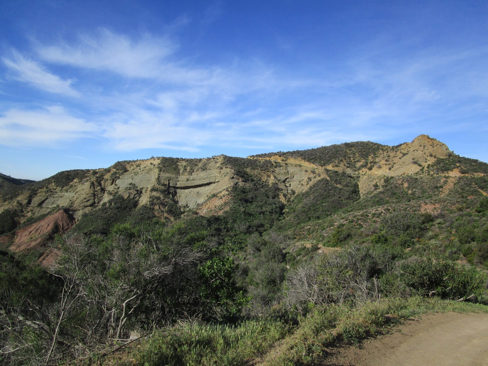
Cathedral Peak right, Arlington Peak left from La Cumbre


Giant satellite dishes near the start of the trail


Greenery at the saddle

The climb up to Cathedral Peak from the saddle is aided by small trees, some trimmed back from the trail. These trees are also useful on the way down, but look out for occasional patches of poison oak. Some minimal route finding is needed around the rocky parts of the ridge. A use trail heads up the east face of Cathedral Peak. About 15-20' of class 3 is required to reach the summit where the ammo boxes and registers are stored. I found six mostly full registers and ended up signing in wherever I found an open spot, even though it put my entry out of date order. Cathedral is a super popular peak and it should be due to the fun factor. I couldn't find any benchmarks. After taking photos and some video, I had some extra time so I decided to continue on to Arlington Peak at the end of the ridge line. The trail to Arlington was clear and easy. I poked around the highest boulders and came up empty on both a register and benchmark. With the marine layer still strong, the view wasn't much different than it was from Montecito. Looking back, the west side of Cathedral Peak was quite dramatic. I finally started my return and found the hardest part of the hike was the 1000' climb back to La Cumbre. Even with Arlington as a bonus, I finished ahead of schedule, then took my place in the snail-like line of cars on the 101 south.


The east side of Cathedral Peak


Class 3 to the summit with a little exposure


Main summit boulder on Cathedral Peak


Three of six registers in two ammo boxes


Shot of the summit from another boulder


Arlington Peak from Cathedral


The impressive west face of Cathedral Peak


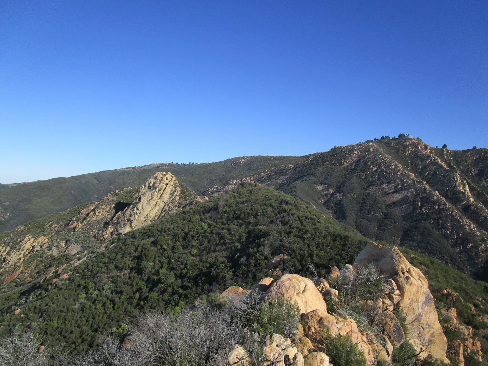
Looking back at Cathedral and La Cumbre from Arlington


Saturday, March 19, 2016

Montecito Peak

Hiked: 3/18/2016
Distance: 2.6 miles round trip on trail and use trail
Summit Elevation: 3214'
Elevation Gain: 950'
Elevation Gain (in Empire State Buildings): 0.76
Round trip time: 1 hour 10 minutes
Recommended water: 16 oz.
Parking/Fees: Free on Camino Cielo
Difficulty: Easy

#52 on the Sierra Club Lower Peaks list is Montecito Peak. It overlooks Montecito, Santa Barbara, and the Channel Islands. The Cold Spring Trail can be used to reach it from the east or the west. I chose the east route since it starts on Camino Cielo and I wanted to hike Cathedral Peak later in the day from the same road.

I left home very early with plans to reach the summit of Montecito before sunrise. I parked at Cold Spring Saddle on Camino Cielo and started down the trail. The morning stars led the way into the void. Apart from a few washouts, the trail was in mostly good shape. Montecito loomed ahead in the darkness. I wanted to see the city lights below, but I only saw a faint glow through the shroud of the marine layer. When I got near the saddle, I found an opening to the ridge and took the ridge all the way up. I got to the summit just as the first blaze of light broke over the horizon. The marine layer hid not only the city lights, but the entire ocean. I searched around for a register but could not find one. I found a reference mark for the summit, but not the triangulation benchmark. I enjoyed the great views, then headed back and drove about 5 miles north on Camino Cielo to a turnout near La Cumbre Peak for the hike to Cathedral Peak.


Heading toward Montecito in the dark


First light on Montecito Peak


On Montecito


Marine layer covering the ocean and Santa Barbara


Montecito reference mark


Looking back at Montecito on the return


Friday, March 4, 2016

Hard-Silver Summit (Peak 3720)

Hiked: 3/4/2016
Distance: 13.3 miles round trip on trail and cross country
Summit Elevation: 3720'
Elevation Gain: 3330'
Elevation Gain (in Empire State Buildings): 2.66
Round trip time: 6 hours
Recommended water: 128 oz.
Parking/Fees: Free on Williams Canyon Road
Difficulty: Strenuous

Deep in the Santa Ana Mountains lies a peak I dubbed Hard-Silver Summit because it is the highest point on the wide ridge that separates Harding Canyon to the south and Silverado Canyon to the north. In Peakbagger, it has the pedestrian name "Peak 3720". To get to the trailhead, take Santiago Canyon Road north from Cooks Corner, then go east on Williams Canyon Road. Park as close as possible to the coned off Silverado Ranch Road going left, anywhere that isn't private property. Hike up Silverado Ranch Road until it turns into a dirt road, Silverado Truck Trail. There are "No Tresspassing" signs, but I ran into the property owner on the way up. He stopped in his truck for a brief visit and had no problems with hikers. He seemed to be more concerned about hunting and fishing. He asked where I was headed but hadn't heard of Peak 3720.

After about half a mile, I made a right turn onto Silverado Truck Trail before getting to the property owners' house. The road started out wide, got increasingly overgrown as I went, and eventually reduced to a single track. About a mile from the start, I found a sign indicating the start of Cleveland National Forest land. An unused and open gate stood shortly past the sign. The trail climbed steadily cutting north and south between peaks on the ridge. The single track narrowed to the point that contact with the brush was unavoidable. It was still easy to follow and the soft plants didn't slow me down. But, I soon noticed some ticks on my pants. I brushed them off and went on, only to pick up several more. I became vigilant and when the day was over, I had a new personal best in collecting ticks: 21. I found the last one in my left boot just before driving home. I suggest drenching your clothes in Permethrin before hitting this trail.


Warning sign, not a problem for hikers at this time


Interesting geology near the start


Turn right before the Ranch House


Cleveland National Forest boundary, about a mile from the start


Looking up Silverado Canyon


Looking up Harding Canyon past a random marker


Basking western patch nosed snake

When I reached the base of Hard-Silver, I looked at the ridge line but didn't see any hint of a use trail. I found a small path to get to the ridge, but assumed it was an animal trail and continued around to the north side. That was a mistake. When I got below the false summit, I started heading directly up, picking my way through dense chaparral. It only got worse as I climbed and eventually it just got completely choked and I had to descend. On the way back, I checked out the ridge and discovered a mostly hidden trail skirting the very edge. The use trail had several obstacles, including some trees that needed to be crawled under and some that needed to be climbed over. Still, it was nothing like the snarl on the wild slope. From the false summit, I had to hunt around for the continuation of the trail and found it heading right. There was some light bushwhacking to the pile of rocks at the high point. The views were nice, even with the sun and low clouds leaving a washed out look on the landscape. It's remote and mostly a pristine part of forest. The trip back was uneventful. By bushwhacking on the north slope, I made this a more taxing hike than it should have been. Elevation gain without my error would have been below 3000'. I marked a waypoint in the GPS track (available on Peakbagger) where the use trail starts. It looks like the trail that comes up Halfway Canyon from Silverado Canyon goes through and would be a much shorter (and steeper) trip than starting at Williams Canyon Road.

Update 3/27/2016
I started up Halfway Canyon Road to find the start of the trail leading up to the Blue Light Mine and Hard-Silver, but the upper part of the road was blocked. It is owned by the Irvine Water District and marked with a clear sign that says "No Forest Access". There is no shortcut this way.


Almost there


Veiled use trail up to the false summit


One of several obstacles on the use trail


Final push


Undecorated summit


Looking south down Harding Canyon


Looking north to Modjeska Peak (left)


Two of the 21 ticks I brushed off, #21 was in my left boot