Monday, March 21, 2022

Corkscrew Peak

Hiked: 3/19/2022
Distance: 7.7 miles round trip on trail
Summit Elevation: 5804'
Prominence: 644'
Elevation Gain: 3338'
Elevation Gain (in Empire State Buildings): 2.7
Round trip time: 5 hours 20 minutes
Recommended water: 72 oz.
Parking/Fees: $35 National Parks Fee (one car for one week)
Difficulty: Strenuous

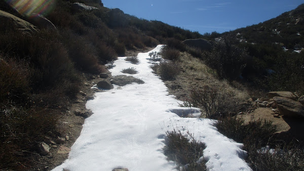
Corkscrew Peak (DPS #58) in the northern part of Death Valley had been on my bucket list a long time. It is not the highest in the Grapevine Mountains, but it stands out based on location and was clearly visible from Furnace Creek more than 25 miles away. Leisa and I drove up Daylight Pass Road to a turnout where the start of a use trail was visible. We were expecting another nice day like the day before, but instead the day was overcast and cool. The forecast called for high winds, and they became an added obstacle.

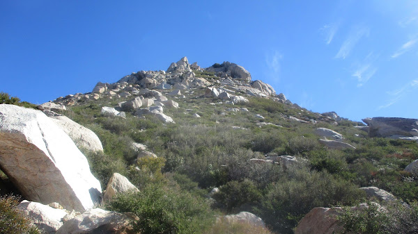
We followed the faint use trail into a wash, then up a rise that didn't look like it connected to any ridges. We followed it anyway and had to drop off into the wider wash as expected. The trail improved the further we went and it was easy to follow all the way up. Several cairns marked the spot to leave the wash and gain the long northeast ridge. The Desert Peaks Section lists Corkscrew as class 2, but we found only one class 2 move to climb out of the wash. The rest of the hike was steep class 1.


Colorful rock garden on the trail

Leaving the wash


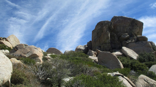
When we gained the ridge, we were blasted with a steady 20-25 mph wind. It was a cool day and the wind made it borderline cold. When we reached the first major rock outcrops, we took a break behind the rocks. There were very few places to get respite and we had to soldier on as the wind hammered us. Corkscrew has two major cliff bands protecting the summit. From most angles, it looked like the only way up was technical. However, the trail cut through the first cliff band of black volcanic rock with ease. Above the first band, there was a short flatish section while the second band loomed above. As we approached, it was clear the trail would split the second cliff band and not require anything technical. The top of the second band ended at "Keyhole Rock", a large oval gap in the wall. From there, it was only a couple of hundred feet to the summit.


Through the first cliff band

Second cliff band ahead

Keyhole Rock


An ammo box with a hardback book served as the register. After signing in, I was delighted with the stunning views. Photos didn't quite capture the depth of the color visible in the rocks. There were sweeping views back down to the Death Valley. We spent a few minutes enjoying the summit, then decided to descend back to the Keyhole to find shelter from the wind and eat lunch. I lingered an extra minute and recorded parts of the descent on video. After a nice break, we continued down. Corkscrew gave up gain faster than expected. It was steep enough to slow us down, but didn't require the care I thought would be necessary. We made great time down, only stopping once along the ridge. After returning to the truck, we drove on to Beatty, NV to fill up on gas. Regular unleaded was a bargain at $6.05/gallon compared to $8.75/gallon back in Furnace Creek. You don't want to buy gas in Death Valley if it can be avoided. Corkscrew exceeded expectations. Highly recommended if you visit Death Valley. note: will add video later


Back at camp


Sunday, March 20, 2022

Golden Canyon Loop

Hiked: 3/18/2022
Distance: 4.4 miles round trip on trail
Summit Elevation: 518' (High point on loop)
Elevation Gain: 811'
Elevation Gain (in Empire State Buildings): 0.6
Round trip time: 1 hour 45 minutes
Recommended water: 32 oz.
Parking/Fees: $35 National Parks Fee (one car for one week)
Difficulty: Easy

Leisa and I drove up to Death Valley for a long weekend. We camped at Furnace Creek and after setting up camp, headed out for a short hike in Golden Canyon. The trailhead is not far from the campground. We chose to head through Golden Canyon and come back through Gower Gulch, completing a loop. There was a lot of people that started up the canyon, but after a half mile, all had turned back. We met a couple of parties that were doing the loop the other direction, but most visitors to Death Valley seem to stick to drive up attraactions. The most interesting feature along this loop (to me) was Manly Beacon, a clay spire with a class 3 ridge. It was not on the menu today, but was the trail went next to it.


Manly Beacon


After a couple of miles, we reached the junction with Gower Gulch. The Gulch was wide and sandy. At one point, we thought we had taken a wrong turn because it didn't appear to continue, but it dropped left down a short dry fall. We followed the trail back to the truck. It was a nice warm up for Corkscrew Peak the next day.


The spike on the way back was from checking out a mine shaft that was sealed

Friday, March 4, 2022

San Ysidro and Hob Benchmark

Hiked: 3/2/2022
Distance: 8.1 miles round trip on trail and cross country
Summit Elevation: 6147' (San Ysidro), 4853' (Hob)
Prominence: 947' (San Ysidro)
Elevation Gain: 3324'
Elevation Gain (in Empire State Buildings): 2.7
Round trip time: 7 hours
Recommended water: 124 oz.
Parking/Fees: Free on Cherry Canyon Road
Difficulty: Strenuous (bushwhack, scramble, route finding)

The San Ysidro Mountains run West-to-East, towering over Borrego Springs. It is high desert terrain, thick with vegetation, cactus, and extruded granite. I wanted to explore part of the Ysidro ridge I had never seen, dropping down to pick up Hob Benchmark on the way back. I started from Cherry Canyon and took a wash around the north side of The Thimble to find the use trail going up to San Ysidro. It was my second summit of San Ysidro, the first nine years ago. After signing the register, I started down the ridge.

San Ysidro Mountains


San Ysidro


Looking down on the Thimble and White Mountain

Borrego Springs and Salton Sea in the distance

The first two major bumps along the ridge were serious bushwhacks combined with bits of class 2/3. I side hilled below the top of the ridge, which was even more overgrown. At least the brush wasn't thorny. Patches of snow remained in shaded areas, but it may only last another week as spring approaches. After a slow crawl over the first two bumps, the ridge opened up a little and I could mostly pick my way through without wading through greenery. I climbed to the high point above Hob for wonderful views. I took a long break there before starting the steep descent to Hob. The slope was sandy and it was easy to plunge step quickly.


Looking back at San Ysidro


Hob was hard to spot among the many boulder piles on the slope. Eventually, I found some wire and part of a post that marked it. I also found a reference mark stamped "Hub" instead of Hob. The local name may have changed over time. I didn't find the station mark or a register. It was nice to finally get Hob since I had walked by it on many prior trips. The rest of the return was uneventful.

Looking down on Hob Benchmark