Distance: 12.5 miles round trip on trail and cross country
Summit Elevation: 10362' (Marion), 10160' (Ellens), 10388' (Shirley), 10170' (Joyce), 10160' (Newton Drury)
Elevation Gain: 4895'
Elevation Gain (in Empire State Buildings): 3.91
Round trip time: 8 hours 30 minutes
Recommended water: 184 oz.
Parking/Fees: Adventure Pass
Difficulty: Strenuous
My goal on this hike was to pick up the rest of the 10000'+ peaks in the San Jacinto Wilderness. It completed an outing from last September. Since that time, I decided to add a couple more unofficial but locally recognized "summits" like Ellens and Joyce. I started the hike on the Marion Mountain Trail, but every one of these peaks is off trail, and every summit is class 2 except Marion at class 3. A free permit is required for the San Jacinto State Park. Here is a direct link to the permit form (PDF). To get there, take exit 100 (8th St/CA-243) on I-10 for highway 243, go south about 20 miles and turn left on Azalea (4S02). Take another left at the first intersection, right at the next three intersections, following the signs to the Marion Campground and Trailhead.
I visited the peaks in this order:
- Mt. St. Ellens (unofficial)
- Marion Mountain (west, middle, east)
- Shirley Peak (unofficial)
- Joyce Peak (unofficial)
- Newton Drury Peak
The Marion Mountain Trail is the shortest, steepest trail to San Jacinto at 5.25 miles one way. In many ways, it reminded me of the Ski Hut Trail on Mount San Antonio. Marion has a couple of very steep sections, but it is mostly moderate with some level sections for relief. I passed the Seven Pines junction, the only one that was fully signed. The other junctions were deficient as far as signage. The junction with the PCT/Fuller Ridge only has a sign for Fuller Ridge, the other trail is a continuation of Marion/Deer Springs. When I got near the Deer Springs Campground, I started looking for a gully to ascend to take me near St. Ellens and Marion. I learned on the way down that a good choice is the gully directly above Deer Springs Campground. However, I made a mistake by picking a point after that. It looked OK to start, but soon I was up to my waist in vegetation. I headed for boulders, islands of calm in the green, but couldn't spot a way out, other than down. I considered bailing out to look for another entry, but I kept thinking I would find a clear path. Eventually, I saw the next gully to the right start to clear out and I fought my way over to it. It was a huge waste of energy and time. If you download my GPS track from Peakbagger, make sure you don't leave the trail where I did. After what seemed like forever, I finally topped out at the saddle between St. Ellens and Marion and headed for Ellens first.

Starting out

Pastel sunrise

Junction with Seven Pines Trail, the only junction with full signage

Junction with Fuller Ridge/PCT, Marion Mountain Trail continues right
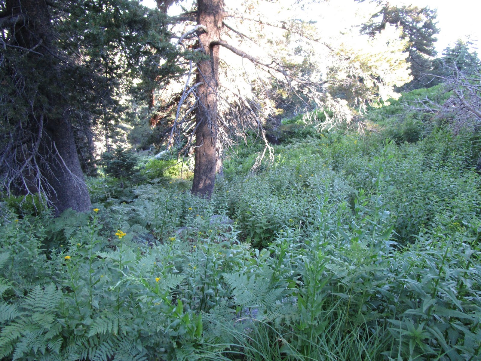
Looking down during my unplanned bushwhack

Looking up, nothing good

Finally back on better ground
The summit of St. Ellens, a locally named peak dedicated to hiker Ellen Coleman, required some class 2 scrambling and avoiding some pine trees. On top was a wooden sign, a register, and a photo album of Ellen's adventures. It was fun seeing who had already visited (not that many), and flipping through the photo album. As soon as I was down, I started off for Marion.

Looking up at St. Ellens from the saddle

St. Ellens summit

St. Ellens register
Marion Mountain is the southernmost peak over 10000' in the San Jacinto Wilderness and the most interesting with a jumble of giant granite slabs making up it's rugged class 3 summit. It was apparently named after Marion Kelly, who worked at the Indian Bureau in Morongo Valley Reservation, by USGS topographer Edmund Perkins. It is also interesting because there are two summits, east and west, (with a lower middle summit in between). The official USGS mark on topographic maps is on the east summit, but the west summit is higher. The Sierra Club register is on the west summit. When I got to Marion, I climbed the west summit first via the crack system that starts behind a dead tree. There is a thin slab sticking out in the longer section that is perfect for using a layback technique, both up and down. Near the top of the crack, it opens to the right making it a little easier to get to the summit. I signed the register that only went back to 2013. After climbing down, I visited the middle summit, then the east summit. Both were class 2. The granite in this area is solid and grips reliable. The rock is nearly ideal. I wasn't expecting to find any benchmarks, and didn't.

Looking up at Marion Mountain

Approaching Marion Mountain summit

The first crack on the west summit

Second crack, perfect for a layback

Looking down from the top of the crack

View south from the Marion summit, Tahquitz Peak and Lily Rock in the distance

Mount St. Ellens on left from the Marion summit

San Jacinto and satellites from Marion

Marion register

The east summit block, class 2

Looking back at the higher west summit from the east summit
Photosphere from Marion Mountain west summit
Next up was Shirley, an unofficial peak sitting just below Jean. Shirley is higher than Marion and the highest point in my day at 10388'. There is a false summit on the way to Shirley, and knowing that, I stayed on the side of it. A little navigation was required to find the best way to the top of Shirley. I found the register in an old coffee can between two slabs at the top.
To get back to Joyce Peak, another unofficial peak named after Hikin' Jim's daughter, I had to backtrack down Shirley, then head across a wide, pleasant, open area. The flat pine forest on top of San Jacinto is one of the most idyllic areas I've visited. I could not see the small outcrop for Joyce Peak until I was right on top of it because of the trees. I didn't find any register or other indication that I was actually on Joyce. I spotted another couple of outcrops a little further out and went ahead and climbed those, too, also finding no register or clues. I am guessing one of the three was actually Joyce.

Shirley Peak summit

Coffee can register on Shirley Peak

Joyce Peak summit (I think)
Last on the list was Newton Drury, named after the fourth director of the American National Park Service. While heading toward it, I could see the manzanita on the southern flank that encouraged people to approach it from the saddle. One thing I learned about the San Jacinto summits is that certain flanks are protected by a moat of manzanita filling all the gaps between boulders. Each needs to be approached on a side free of manzanita. I had to wind around to the saddle, then found a faint use trail heading up. Along the way, I stumbled over an abandoned camp site near a dry stream, just south of Newton Drury. The summit was obscured by trees until I was just below it. It had a standard register in red cans. I relaxed on top and ate lunch, enjoying the perfect weather and solitude. I hadn't seen a single person all day and felt like I owned all the mountains. I was tempted to fall asleep in the sun, but reluctantly gathered my things and made my way down the north side, heading for the Deer Springs Trail. I followed an unnamed trail that dumped me out at "Owl's Hooch" camp site along the Deer Springs Trail. From there, I headed back toward the Marion Mountain Trail. "Bed Springs" was flowing nicely across the trail. On the way down, I ran into a dozen or so hikers and trail runners, all headed for San Jacinto.

Looking down on Newton Drury, needed to traverse to the saddle to avoid manzanita

Abandoned camp site and fire pit below Newton Drury

Approaching Newton Drury

Newton Drury summit and register

Owl's Hooch camp site on the Deer Springs Trail
Newton Drury 360


