Sunday, January 30, 2022

Oasis Peak

First Ascent
Hiked: 1/28/2022
Distance: 6.8 miles round trip cross country
Summit Elevation: 3723'
Elevation Gain: 2000'
Elevation Gain (in Empire State Buildings): 1.6
Round trip time: 4 hours 30 minutes
Recommended water: 64 oz.
Parking/Fees: Free on dirt road behind Chiriaco Summit Campground
Difficulty: Moderate (route finding, scramble)

I've been interested in the untouched wilderness in Joshua Tree National Park just south of Eagle Mountain. There are several compelling peaks that appear to be unclimbed, or at least there are no documented ascents. There is also a rectangular area of jagged rock formations that are visually stunning and extremely remote. Places like this draw me like magnets. I call this rectange the "Wrecked Tangle". While researching the area, I noticed John Morrow had created a provisional peak in Peakbagger called "Oasis Peak", the topo map labelled it 3723'. He likely named it after nearby Lost Palms Oasis, a destination Leisa and I visited just weeks ago. There were no attempts in Peakbagger. There were no attempts listed in Listsofjohn.com. There was no attempt by Bob Burd. I suspect it might have been climbed earlier since it is only 3.5 miles from I-10, but until I can find evidence, I'll claim the first ascent!

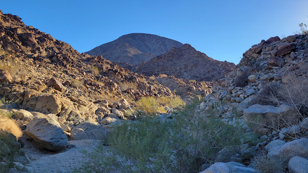
I drove north from the Chiriaco Summit exit on I-10, past the General Patton Museum, and past the dry campground to a turn around at a gated dirt road into Joshua Tree. I am not sure an entrance fee applies here, but I had a National Forest annual pass and I carried it with me. It would be a rare bit of luck to run into a park ranger in this area. I mapped a route using Caltopo to follow a wide drainage north, then gain the ridge at a low saddle at 2600'. On the map, it looked like straight up the ridge was best, but route finding led me to the north side of the ridge in many places. The approach was sandy and easy. There was an elevated shelf east of the main wash and it was thick with dangerous cholla. I stayed off this shelf until I had to cross it. The short climb to the lower saddle was easy.

Tanks at the General Patton Museum

Entrance to JT

Oasis Peak ahead

Passing through the cholla forest

From the low saddle, I angled below the ridge line around major obstacles

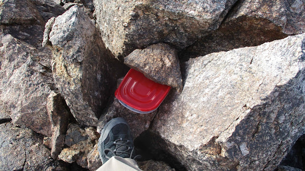
Terrain after the saddle was mostly class 2, with some class 3 near the top of the ridge. There were two false summits along the ridge until I saw the true summit at the end of the ridge line. After passing the second false summit, it was a walk up. Two small piles of boulders competed for the high point, but the one at the very end of the ridge was slightly higher. That's where I placed a register in a plastic sandwich box. Like on Orocopia, the wind was screaming. I had to hold my hat down even though it was strapped under my chin. I got a great look at the "Wrecked Tangle", even more jagged from a closer perspective. Fantastic scenery all around. I searched for any kind of mark but there was nothing. I started back the same way, though I drifted low along the north slope too early. I think my ascent line was cleaner. I took a break half way down to rest and appreciate where I was. I noticed something metal in the middle of the cholla forest and diverted my return slightly to investigate. It was the shell of an old car set up as some kind of shelter. Next to it, I found 3+ gallons of water stored in barrel. My guess is it was shelter for migrants. It didn't look like an official park service waypoint. I left it as it was and returned along the wash. As a safety note, I didn't have cell service at Chiriaco Summit or anywhere on the hike. Cell service was not available to call for help in this area. I got back to the truck right at sunset. I'll end with a quote from Ryan Holiday: "The obstacle is the way".


First false summit

True summit ahead


Looking into the Wrecked Tangle

Looking back along the ascent ridge


Saturday, January 29, 2022

Orocopia Mountains High Point

Hiked: 1/28/2022
Distance: 5.2 miles round trip on trail and use trail
Summit Elevation: 3815'
Prominence: 2095'
Elevation Gain: 1637'
Elevation Gain (in Empire State Buildings): 1.3
Round trip time: 2 hours 30 minutes
Recommended water: 32 oz.
Parking/Fees: Free on dirt road MC133
Difficulty: Easy

The Orocopia Mountains are south of the I-10 and Joshua Tree. You can get there by taking the Cottonwood exit and going south on dirt road MC133. The trailhead is about 6 miles south. The road was in pretty good shape with one small 4x4 section, a slightly rutted 20' hill. If your vehicle can't make the hill, you can park below it and walk an extra half mile. There was a white van at the trailhead, but no sign of people around. The high point is #86 on the Sierra Club DPS list and it sports over 2k in prominence. The trail starts out as a dirt road and winds southeast as it approaches the mountains. I left the road where I could gain easy access to one of major ridges. Shortly, I spotted a use trail that stuck to the ridges and I was able to follow it all the way to the summit. The summit was not visible early on, and only became obvious as I got close to it. There was quite a bit of up and down on the rolling hills. The entire range was nearly barren of vegetation. Even grass had a hard time making a living in these mountains. The final slope was very steep. As I closed in on the summit, the wind howled. With no shelter, it got cold and I only spent enough time on the summit to take photos and sign the register. The benchmark was intact, and two reference marks were also in good shape. A 4' cairn had been constructed at the summit and there were nice views of the Salton Sea. I didn't take a break until I was well on my way back and out of the wind. Didn't see anyone the whole trip. My next challenge for the day was an attempt on Oasis Peak in southern Joshua Tree, a possible first ascent.


Monday, January 17, 2022

Lost Palms Oasis

Hiked: 1/16/2022
Distance: 8.6 miles round trip on trail
Summit Elevation: 3130' (at the oasis)
Elevation Gain: 1200'
Elevation Gain (in Empire State Buildings): 0.9
Round trip time: 3 hours 30 minutes
Recommended water: 48 oz.
Parking/Fees: $30 National Parks Fee (one car for one week)
Difficulty: Moderate

Leisa and I camped at Cottonwood Springs in the southern part of Joshua Tree. It was suprising cold, even for January, and we burned more wood for the fire than planned. We accidentally left some food out over night and the coyotes took advantage. We heard loud yipping at 4 AM and the food was gone in the morning, packaging dragged 25' from the site. There was a spur trail in the campground that connected to the rest of the trail system. We had arrived the day before and did a warm up hike to Mastodon Peak. Since it only adds about a mile, Mastodon is often combined with the Oasis hike. The trail was sandy and smooth. It passed by dozens of giant boulder piles and Eagle Mountain was visible to the north. With cool temperatures, we didn't see anything in the way of desert wildlife other than an occasional lizard. The trail seemed flat, but there were numerous small bumps as we moved in and out of washes and adjoining ridges. At the end of the official trail was a sign with a warning about descending into the canyon to reach the oasis. You can't see much of the oasis from the sign, so you have to either partially descend or continue past it to look down on the palms. It was about 100' down to the oasis, and there were a couple of use trails, one much better than the others. I didn't find the best way down at first. Much of the descent path was covered in tiny pebble scree, making footing a concern. Leisa was unsure it was worth descending into the canyon at first, but followed a couple just behind us who did find the best way down. My own scramble down was class 2 and I met up with her at the bottom. The oasis was filled with dozens of beautiful palms and we followed the canyon another thousand feet to some comfortable rocks. We rested for a while as other parties began heading back up. We were able to follow the best use trail on the way back and footing was less of a concern going up. It was quite a popular trail on this MLK holiday weekend.


Sunday, January 2, 2022

Eisenhower Mountain Loop

Hiked: 1/1/2022
Distance: 6.6 miles round trip on trail and cross country
Summit Elevation: 1952'
Elevation Gain: 1730'
Elevation Gain (in Empire State Buildings): 1.4
Round trip time: 4 hours 15 minutes
Recommended water: 64 oz.
Parking/Fees: $27.95 admission (adult) to Living Desert Zoo
Difficulty: Moderate (cross country scramble)

I celebrated New Years Day by getting Eisenhower Mountain, another peak along the La Quinta ridge. The approach was a trail in the Living Desert Zoo. Admission was not cheap, but this was by far the easiest route to Eisenhower. I got to wander around the Zoo after the hike as a bonus. I was customer number three on the day when the park opened at 8 AM. I stayed left from the entrance to reach the start of the desert trails. I planned to do the complete loop, up the Canyon Trail and down the Ridge Trail. The Canyon Trail dips in and out of a wash and the second exit was not easy to find. I had to make a course correction. Somewhere along the trail that cuts across Eisenhower, I planned to leave the trail and scramble up. I almost went up the first major gully I came to, it looked like it could go, but the trail climbed a little higher before I needed to leave it. I continued all the way to the picnic table, about the half way point on the loop.

Eisenhower on the left


Looking up the rocky ridge

I picked a line left of a big outcrop and took that to gain the north ridge. The ridge rose 950' in about 0.4 miles. It looked steep enough to hit class 3, but remained class 2 all the way. I was surpised to find some useful cairns marking a path up. The summit was flat with a couple of competing boulders, one standing a few feet above the others. There was some black PVC tube that had fallen down and some broken boards. I didn't find any marks or a register. I took a short break on top, but it was cool and windy so I didn't linger. I did look down the other side where a trail heads down to a private golf club (shown on Openstreet Map). The view down the ridge to LaQuinta BM looked fun, but would have taken too much time to get there and back the same day. Also, there was no good bail off point from LaQuinta without coming out in a private gated golf club. There may be a way to leave the Living Desert trail and approach LaQuinta. Research for another day. I returned down the north slope the way I came up. It was slow coming down due to loose rocks and the angle. Once I got back to the trail, I continued around the loop on the Ridge Trail. I stopped the GPS when I got back to the Zoo, then roamed around looking at animals. It was a fun hike to start 2022.


Snowy San Jacinto


Looking back at Eisenhower

Cheetahs