Saturday, July 21, 2018

Antsell Rock and Apache Peak

HPS Star Emblem Peak
Hiked: 7/20/2018
Distance: 7.2 miles round trip on trail and cross country
Summit Elevation: 7679' (Antsell), 7567' (Apache)
Prominence: 519' (Antsell), 687' (Apache)
Elevation Gain: 3156'
Elevation Gain (in Empire State Buildings): 2.52
Max Slope: 68%
Round trip time: 6 hours 50 minutes
Recommended water: 96 oz.
Parking/Fees: Free on Apple Canyon Road
Difficulty: Strenuous

Named after a local artist, Antsell Rock is the most difficult peak on the Desert Divide, a high and jagged ridge running south from San Jacinto Peak. Jerry Schad called it the jewel of the Divide. From his book, Afoot and Afield: Inland Empire:
...its stony buttresses make an impressive sight from most directions. It is also one of the few mountaineers’ peaks in Southern California that requires more than the usual plodding to reach the third class summit.
Sean and I drove up Highway 74 to the Zen Mountain Center visitor parking lot. The last mile of Apple Canyon Road is a good dirt road and the parking lot was on the left. We walked past the entrance gate and stayed left at two road splits. We continued up the dirt road past three water towers on the left, then continued straight past the first switchback to the start of the trail. The climb up the Zen trail is steep in parts, gaining about 1300' in a little over a mile. Vegetation is starting to encroach on parts of it, but cairns and orange ribbon kept us on track most of the way. There was still a lot of burn damage from multiple fires in the past. Near the top, it got a little confusing where deer trails competed with the eroded main trail. We managed to stay on track and emerged onto the PCT at the saddle between Antsell Rock and Apache. From there, it was a quick half mile to the east ascent gully, marked with its own rock cairn. There was no visible damage to the PCT.


Water tanks, trail starts directly ahead past road switchback


Looking down Apple Canyon


Start of ascent gully

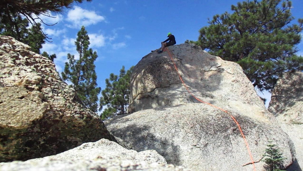
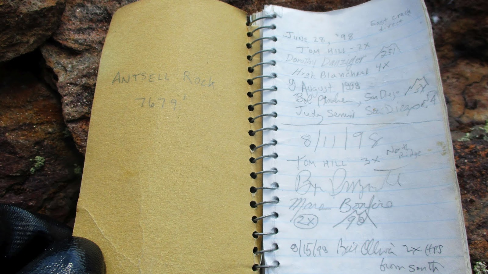
The ascent gully was very steep, rising about 750' in a third of a mile. It was sandy, loose, and challenging. We both dislodged huge rocks on the way up and I often used vegetation to assist my climb. As the gully narrows at the top, some class 3 scrambling over boulders and trees was necessary. I was a sweat faucet when we reached the top of the gully, the base of the Antsell summit. The other popular route to reach the base is the north ridge. At the base, I instantly recognized the starting class 3 crack from Hikin' Jims 2013 report. I collapsed my trekking pole and placed it in my backpack, then started up. The pole got hung in part of the crack, so as soon I reached the first ledge, I removed it from my pack and threw it down to the base. It would have been a dangerous hazard the rest of the way. Sean waited until I reached the top of the crack before starting up. We continued over the top boulders to find the dead pine tree, a sign we were on the right track. We passed left of the tree, then ducked under some small pines on a down sloping slab. This got us into the "brushed up" gully. It appeared that someone had done some clipping, because we found a relatively clear path to the next class 3 section. I went first again and when Sean made it up, we angled left for easier terrain. We took different class 2 lines to the summit. Sean opted for a more direct, but more exposed track, and I switched back more to the right. On the summit was a pole marker and a small US flag. Standard HPS red cans held the register that went back to 1998 and was a little more than half full. I searched to find Hikin' Jims entry and noted the others climbers I knew. We didn't find a benchmark. The views were magnificent. We took a fairly long break to enjoy the summit and tried to capture photos that did it justice. I don't think we succeeded in the latter. After signing in, we reversed course. Going down the steep gully was as slow and difficult as going up. Once back on the PCT, we hiked past the Zen trail and headed for Apache Peak.


Narrowing gully


Sean above a scramble section


Sean climbing the first crack


Continue over these boulders


Dead tree section and brushy gully


Next class 3 section


Sean reaching the summit


North ridge, the ascent gully is on the right before the bump


West ridge


Apple Canyon


South ridge


The dual peaks of Apache were not far from the saddle, less than a mile. Although it is lower, the east summit looked higher to me most of the day. I misread the GPS and led us a short distance past the place we needed to leave the trail. We back tracked past a giant rock outcrop and Sean stashed his pack before the ascent. A patchy use trail led to Apache. It cut through shin level buckthorn that had grown over the trail in places. There was no register or benchmark among the boulder piles on the summit. Like Antsell, Apache had great views down into Apple Canyon. Since the east summit was so close, we paid it a quick visit, but found nothing of note. Dark clouds had boiled up as the afternoon approached, keeping us cool. It looked like it was raining on top of San Jacinto, but rain never felt imminent where we were. We cruised back down the Zen trail to wrap a memorable day.


On the way down, my trekking pole where I threw it


The desert side of the desert divide


Sean climbing up past the giant outcrop


Apache Peak summit


Antsell Rock from Apache


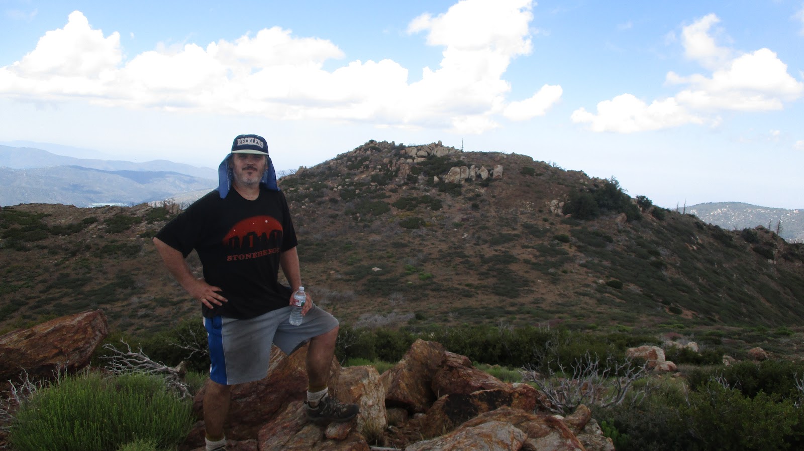
Sean on Apache East with Apache in the background


Other reports:
Hikin' Jim (north ridge approach)
Peaks for Freaks (east gully approach)

Sunday, July 15, 2018

Wild Things v8

Hiked: 7/15/2018
Distance: 8.4 miles round trip on trail and cross country
Difficulty: Moderate

These cougar videos were the culmination of 8 months, 3 camera adjustments, and 42 miles of hiking. The story actually starts almost two years ago in August, 2016 when I became enamored with Bluewater Canyon. First, I climbed the highest peak bordering the canyon, that has no official name, but I called it Bluewater Crown. Then, I persuaded Sean Green and Dima Kogan to do a complete circumnavigation around the canyon with me (>20 miles). That was followed by a solo exploration off trail of the canyon itself where I found a dismembered buck. That was somewhat unsettling since I was convinced the buck had been killed by a mountain lion aka cougar. To confirm my suspicion, I bought a trail camera and placed it where the buck was, but my placement was poor and the only thing I got on camera was another deer. Steve Andrews went back with me to do a more thorough exploration miles up the canyon in rough country and I adjusted the camera, getting my first fleeting video of a cougar. I went back with Robert Dlugos for another camera adjustment in April, 2018, and finally did another solo trip to pick up the camera today. I was overjoyed getting great video of not one, but two cougars, apparently a male and female in courtship. Neither cougar was tagged and the male has scars on his face and body. Other wild life caught on video include a bobcat, deer, fawn, and a grey fox. Best of all, I wasn't eaten.


Some stills...


Gorgeous female with some light striping on her legs


Huge scruffy male with major battle scars


Female calling


Bobcat


Watch out, Bambi

See also:
Fisherman's Camp, Bluewater Canyon, San Mateo Canyon

Sunday, July 8, 2018

Pacifico Mountain Loop

HPS Star Emblem Peak
Hiked: 7/8/2018
Distance: 12.5 miles round trip on trail
Summit Elevation: 7124'
Prominence: 1563'
Elevation Gain: 2530'
Elevation Gain (in Empire State Buildings): 2.02
Round trip time: 6 hours 30 minutes
Recommended water: 96 oz.
Parking/Fees: Adventure Pass (signed)
Difficulty: Strenuous

Sidebar on difficulty: It was strenuous because I carried a rope and gear adding 10 pounds to my pack. If I had left the rope at home, it would have been moderate, but I probably would have skipped the summit block.

Pacifico Mountain had been on my radar a while. It had respectable mileage, big prominence, and a summit full of fun looking granite boulders. The highest summit block was a twenty footer that Bob Burd rated as class 3 but Summitpost and most other people rated as class 4. I could not tell from photos alone, so it gave me an excuse to dust off the rope gear and brush up on my rope skills. We were also in the midst of a record smashing heat wave and a heat advisory was in effect. The high at the trailhead was supposed to be 91F and I had something to prove in the heat after making mistakes the previous month coming down from Big Iron.

I arrived at the Mill Creek Summit at 5:45 AM and was the only car in the Pony Park Day Use parking lot. It was 73F. I started up the sandy Pacifico Mountain Road looking for animal prints. The only prints I found were from a horse (all the way to the summit) and occasional deer prints. No signs of carnivorous predators. The road stays below the major ridge most of the way, providing excellent shade in the early morning. There were good views of the front range classics. As I neared the top, pines started to dominate. Below the summit, the road intersects the PCT. There was a steep use trail up the west ridge, but I was lugging a rope and gear and decided to take the winding road around. The summit smelled strongly of pine and there were no campers or picnickers around. I had the entire mountain to myself. Plenty of tables were scattered around and there were two bathrooms on the summit. Delightful.


Mill Creek from the road


Round Top (left) and Granite (right)


Major summit blocks, highest on the left


A pipe on a lower summit block


Highest summit block from the side


Lower summit area


The elusive Pacifico register from 1992


Benchmark on a flat boulder behind the summit block

I did a quick tour of the granite summit blocks, then focused on the highest one. I am pretty conservative with YDS ratings, but at first, I thought maybe Bob was right. I saw some good holds on the block. When I actually got up on it, I changed my mind. There were three good holds leading directly to the pole sticking out on top (see image below). For it to be class 3, I think it needed a foothold somewhere in the orange area (see image below), and there was nothing good. There was another good hold on the right, but again, no foothold to support moving that way. A friction move was needed to reach the third hold and I didn't want to make the move unprotected. I came down and unpacked the rope and gear. After slinging it over the top, I anchored it to a pine tree with some girth. I protected myself with two prusiks and got back on the rock. I didn't use the rope as aid, only protection. I couldn't find an acceptable place for my right foot, so I switched to my left foot for the friction move. Once I got the third hold, the rest was easy. After taking a few photos, I rappelled down the main block and the one in front of it. I changed back into my hiking boots and climbed the other class 3 blocks. I found empty pins on all of the them. There was a Dept of the Interior benchmark on a flat boulder behind the summit block, but I didn't find any of the reference marks. The register was in a pair of HPS red cans wedged deep between slabs behind the summit block. I signed in, noticing that there weren't many signatures. It was hard to see and I suspect a lot of people never found it. I moved it to a more conspicuous place in the wedge so it would be easier to find.


Anchor on the pine tree, register was under the big slab on the left,
where the rope goes over the rock


Ascent side


Rappel

I spent almost an hour and a half on the summit, most of that time juggling rope gear. I took the steep west ridge use trail down to intersect the PCT. It was nice to have different scenery on the way back. There were a lot of burned areas but otherwise nothing remarkable. The heat built steadily as I descended, but I was in control. I had a lot of water left, including one bottle I had frozen the night before. It had melted but was still cold. I took a couple of short breaks in the shade on the way down, making it back about an hour before my plan.


Pacifico from the PCT


Cruising down the PCT


Charred


There's something about Mary