Friday, April 27, 2018

Stage BM and Moonlight Peak

Hiked: 4/26/2018
Distance: 11 miles round trip cross country
Summit Elevation: 2816' (Stage), 2620' (Moonlight)
Elevation Gain: 2777'
Elevation Gain (in Empire State Buildings): 2.22
Round trip time: 6 hours 30 minutes
Recommended water: 100 oz.
Parking/Fees: Free at S2 turnout
Difficulty: Strenuous (combined)

I parked at a turnout off S2 (Great Southern Overland Stage Route) a couple miles south of Agua Caliente State Park. It was already light at 6:20 AM and I aimed to bag Stage Benchmark (SDC #77). If I had time and the will, I also planned to get Moonlight Peak (unofficial). I began in a wide, sandy wash that gained 700' over 3 miles before depositing me in the Inner Pasture. From this side of Stage, I could make the best approach up a steep gully. The cactus and boulders were not as harsh as Sunset Peak, but there was plenty of agave and cholla. Near the top of the first gully, my left foot came down hard near agave and a sharp point drove deep on the inside of my ankle. Blood seeped through my sock. I've been tagged by agave and yucca many times, so I resolved to dab it with antibacterial ointment at my next break. Ten minutes later, my ankle was throbbing unlike any agave wound I'd endured in the past. I stopped to take my shoe off and examine it closer. Because the level of pain was unexpected, I looked for a second puncture mark thinking maybe I got hit by a unseen snake. I didn't want to fail on Stage from a snake bite, but was ready to activate my PLB if needed. I only found one puncture mark, but decided to watch the swelling. I was only half a mile from the summit, so I continued up, scrambling and dodging cactus. Aspirin and adrenaline got me to the summit. I found the benchmark and two reference marks. The register was a small booklet placed by Wes Shelberg in 1984. It was weathered but only about half full. Good views all around, especially of the Inner Pasture and Sawtooth Mountains. I checked my ankle. It was red and still sore, but the swelling was minimal. I headed down and made the game time decision to attempt Moonlight Peak, adding roughly 3 miles to my round trip.
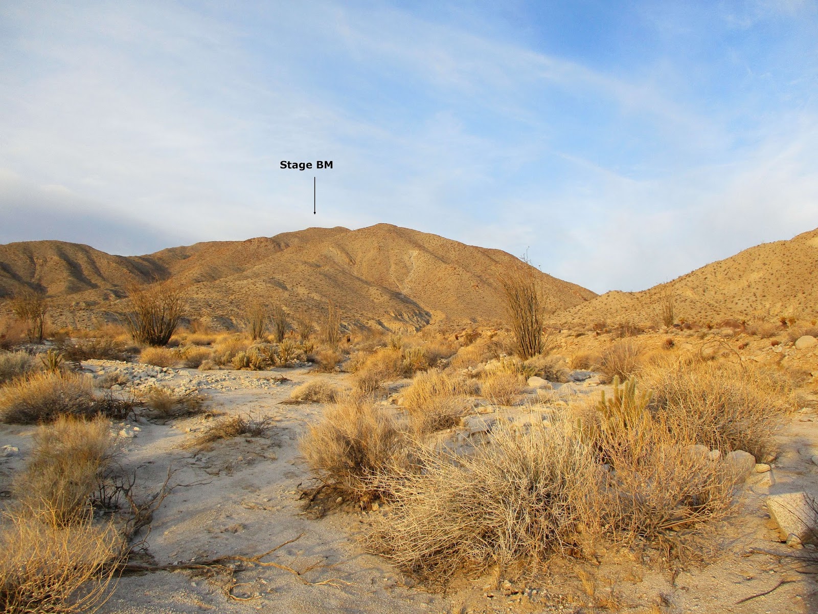

Stage at the start


Heading for the major gully


Scrambling near the top


Broken barrel


Summit with Red Top in the background


Sombrero


Inner Pasture


Register from 1984


When I planned the route to Moonlight, I initially drew a line straight up a ridge from the wash but after analyzing the details, created a safer route from the Inner Pasture. I walked about a half mile west before going up a ridge, then down to a saddle connecting to the major spine. After the saddle, I followed a faint sheep trail littered with scat. I stopped intermittently to scan for bighorns but didn't see any. To get to Moonlight, I had to go over a class 2 bump, a little more scrambling for the day. Temps heated up to near 90F. The summit had a register, placed in December 2016, made of cut pieces of a chemistry test from 1979. Four people from the "Friday Fanatics" signed it when they placed the register and Don Raether signed it in 2017. I was the sixth person to sign it, making me feel like part of an exclusive club. Most of the big time San Diego hikers hadn't made it here yet. There was no benchmark on this unofficial peak. The views of the Sawtooth Mountains were even better here than from Stage. I was glad I made the side trip. On the way down, I dropped down a gully at the last saddle. The sandy hike out was pleasant and uneventful. As I packed up to head home, my ankle started throbbing again. Adrenaline had worn off and it looked worse than it had 4 hours earlier. At home, it continued to get worse. I treated it with benadryl and ice, and it started to fade the next morning.


The class 2 bump and Moonlight


Stage BM from the Moonlight summit


Sawtooth Mountains from Moonlight


Moonlight from the wash on the way out


Monday, April 16, 2018

Perpendicular Bluff

Hiked: 4/13/2018
Distance: 2.6 miles round trip cross country
Summit Elevation: 1741'
Elevation Gain: 685'
Elevation Gain (in Empire State Buildings): 0.54
Round trip time: 1 hours 30 minutes
Recommended water: 20 oz.
Parking/Fees: Free on Highway 78
Difficulty: Easy

After Sunset Mountain, I had a little spare time so I searched Peakbagger.com for a bonus peak nearby and found Perpendicular Bluff BM. I drove about half a mile west on Highway 78 and parked on the north side. I am not sure what this bluff is "perpendicular" to. The summit is not visible from the start. I wandered toward the base of the foothills trying to figure out which ridge would connect. I started into a wash, scaring a large jack rabbit up the opposite side, then gained one of the south ridges. From the top of the ridge, I could see a clear continuation over reddish volcanic rock. Compared to Sunset, the angles were mild and the ground stable. Also, there was far less cactus making it a pleasurable junket. I snagged a couple of mylar balloons on the way up. On the summit plateau, I had to check several mounds before finding the benchmark and register. The register bag was torn so I replaced it with a fresh baggie. I thought this peak was somewhat obscure, but it appeared to be popular with many repeat visitors over the years. The benchmark was placed by the Army Corps of Engineers, who engraved a spelling error on the mark. Perpendicular was stamped "PERPINDUCILER BLUFF", 1957. Hoo-ahh! There was a fine view of Borrego Springs and a view of Sunset from the east that made it look imposing. I tried to take a more direct path to the truck, following a different ridge and taking another wash, but it did not really save time..


Start, summit not visible


Plateau


Sunset from Perpendicular Bluff

Saturday, April 14, 2018

Sunset Mountain

Hiked: 4/13/2018
Distance: 4 miles round trip cross country
Summit Elevation: 3657'
Prominence: 1057'
Elevation Gain: 1988'
Elevation Gain (in Empire State Buildings): 1.59
Round trip time: 3 hours 50 minutes
Recommended water: 72 oz.
Parking/Fees: Free on Pinyon Wash
Difficulty: Moderate

I drove back to Anza-Borrego to chip away at the Sierra Club San Diego Peak List. Today's test was Sunset Mountain (#57), a P1K in the northern Vallecito range. The trailhead is south of Highway 78 in Pinyon Wash. I enjoyed the off road drive that only had a little deep sand. It can probably be driven by any vehicle, but to be safe, I'd recommend 4x4. From my parking spot, I walked across the flat desert toward Sunset. I dodged cactus from the beginning. The cactus population consisted mostly of cholla, agave, ocotillo, and barrel cactus, in that order of frequency.

After ascending the main wash a short distance, I started up a slope on the left. The angles were steep and the non-boulder sections were decomposed granite. The chossy crust on the dirt often gave way. Class 2 boulder sections came up now and then and were a welcome oasis of stability. There were no signs of a use trail or animal trail over the very rough terrain. Once in a while, I'd see a random foot print/hoof print in the sand. Route finding was mentally taxing. In addition to avoiding the cactus and agave, almost every step required careful attention. On boulders, I checked for loose rocks and gaps. On the slopes, each step had to be tested before committing to it and risking a slide. There were only a few breaks from the grind, short 100' lines in a wash or flat area. Other than that, it was slow, steady progress kept manageable by the short distance.


Sunset from Pinyon Wash


Ocotillo bloom


Looking down from a slope


Climbing to the false summit

As I cleared a false summit, I hit the edge of the northwest ridge and was greeted with awesome views into Lower Borrego Valley. Suddenly, all the work was worth it. A short time later, I was on the summit. The benchmark and register were about 25' from the highest boulder. The benchmark was stamped "Yak", matching the USGS topo, although the topo also named the mountain as Sunset. On top, wind blew steadily with gusts in the 25mph range. The summit had good views, but they didn't match the edge of the ridge just below. There were several books in the register cans and I signed the latest one before packing up and heading down out of the wind. I stopped on some rocks for a break, taking in the almost unnatural silence. I had seen some bighorn scat and a couple of birds near the summit, but no other wildlife of any kind. When the wind was still, nothing moved and nothing made a sound. I'm used to being alone on remote desert peaks and the silence was notable. I continued the knee-busting descent, glad to get down without incident. I finished in pretty good time and pulled up peakbagger to look for a nearby bonus peak. I found one just on the other side of Highway 78 called Perpendicular Bluff.


View to Lower Borrego Valley


Yak, 1939


Adam's sig


Looking east


Southwest, Granite Mountain distant right


South


Slow descent


Final look back


Thursday, April 12, 2018

Wild Things v4 [Gold!]

Hiked: 4/12/2018
Distance: 1.2 miles round trip on trail
Difficulty: Easy

I pulled my trailcam away from the watering hole near a popular trail in the Santa Ana Mountains so I could deploy it back to the deep forest inside the proven hunting grounds of a mountain lion. But I struck gold over the last two weeks as the animals were very busy. I even got a full shot of a lion, the holy grail of mythic animals in the mountains. In a few months, I am going to be tempted to put it back to at this watering hole or find someplace similar. Hey, everything needs water. I've broken up the photos by sections in this order:
  • Turkey Vulture
  • Raven
  • Coyote
  • Bobcat
  • Mountain Lion (Cougar)


The coyotes are moving around in the daytime and at night. They don't seem to have a set schedule. Exit photos show some of them moving upstream on the rocks to the right, while others head up the hill at the back. There is a faint use trail there that people and dogs also use.


Bobcats are fast. I have many trailcam shots of half a bobcat or a bobcat moving blur. Some of these shots are solid and the bold patterns on the fur would make any cat proud. This particular bobcat haunts the area and is seen on multiple consecutive days. They are notoriously hard to photograph in person. I've seen fleeting glimpses of half a dozen but never gotten a clean photo.


This lone full body shot of a mountain lion (cougar) was a shock. She only visited the watering hole once in the previous month, maybe because water is drying up in other parts of the creek. She does not appear to be collared or tagged, but there isn't a clear view of her ears. She appears to be hunting and exits upstream to the right. Wow!