Friday, September 27, 2013

Cahuenga Peak, Mt. Lee, Mt. Hollywood

Hiked: 9/27/2013
Distance: 8.6 miles round trip on trail
Summit Elevation: 1820' (Cahuenga Peak), 1680' (Mt. Lee) , 1625' (Mt. Hollywood)
Prominence: 1030' (Cahuenga Peak), 40' (Mt. Lee) , 265' (Mt. Hollywood)
Elevation Gain: 1783' (combined)
Elevation Gain (in Empire State Buildings): 1.42
Round trip time: 2 hours 50 minutes
Recommended water: 54 oz.
Parking/Fees: Free in Griffith Park
Difficulty: Moderate (combined)

In a week with limited hiking time available, I chose to pick up a couple of LPC peaks in Griffith Park, and cruise by the Hollywood Sign. The traffic was bad on the freeways to get into LA, making it a white knuckle, horn honking adventure that was a mental drain before I started. Once I got off the freeways, I headed up Canyon Drive and parked at the last parking lot before the road is gated. The Brush Canyon trail starts right past the fence at the end of the road. This spot is in between Mt. Lee and Mt. Hollywood and a good starting point to navigate the maze of trails in the park. Some of the trails are dirt roads, some are paved, and there are a few single tracks. Almost everything is a mild grade with slightly sharper angles on the use trail to Cahuenga Peak. The Brush Canyon trail ends at a junction with Mulholland trail where I went left toward the Hollywood Sign, the main prize. Shortly, I hit the paved Mt. Lee trail and turned right as it winds around behind Mt. Lee on the opposite side of the Hollywood Sign. It's funny that the Hollywood Sign is not on Mt. Hollywood. It is, however, protected by a fence with plenty of warnings and a visit from a police helicopter about every 30 minutes. The best view is from the summit of Mt. Lee where I took the panorama. I saw no benchmark or register on Mt. Lee.


Starting up Brush Canyon trail


The Hollywood Sign from the summit of Mt. Lee


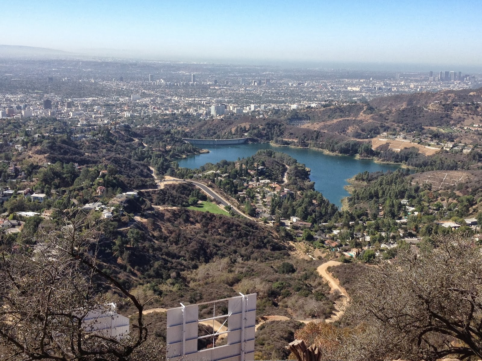
The Hollywood Reservoir


Cahuenga Peak from Mt. Lee

I only spent a couple of minutes on Mt. Lee before making the 20 minute trek to Cahuenga Peak, the highest point in Griffith Park. The trail to Cahuenga leaves right behind a monument in its honor just below the Mt. Lee summit. The single track was more fun than the wide dirt and paved trails that blanket the park. Cahuenga had a benchmark, but no register. After a few photos, I was on my way back to Mulholland trail on the way to Mt. Hollywood.


Monument to Caheuenga Peak, the use trail to Cahuenga right behind it


Downtown LA from Cahuenga Peak


Coming down from Caheunga Peak

There were a lot of people on the trails. Runners, hikers, dog walkers, bikers, and 6 people on horseback. While it is not downtown LA, there is no sense of isolation or wilderness. I reversed my path on Mulholland, then continued past the junction with Brush Canyon. I made a right turn at the paved Hollywood trail, then the next left up the dirt road toward the water tank and Mt. Hollywood. I spotted a use trail up the ridge just after the first switchback that went past the water tank and directly to the summit of Mt. Hollywood. There were a dozen people milling around on the summit, taking photos and resting. There was a City of LA benchmark, no register, and four picnic tables on the summit. I sat down and had the one snack I brought. The weather and views were as good as they get, except for the light brown haze of smog. I jogged about half way back to the car before stopping when a coyote ran into the trail in front of me. By the time I got my phone ready, he was a ways down the trail, looking back at me every few seconds to make sure I was not a threat.


Heading to Mt. Hollywood


City of LA benchmark on Mt. Hollywood


Mt. Lee and the Sign from Mt. Hollywood, Cahuenga Peak rising in the background


Panorama of LA from Mt. Hollywood


Coyote on the trail on the way down

The down side of having hiked all the nearby peaks is that I have to drive a long way to find one I haven't climbed. It was painfully so in this case, driving through downtown LA on the I-5 and 101 during rush hour. It took me an hour an 45 minutes to get to the trailhead, and an hour and 30 minutes to get home. Only one wreck slowed things down so it could have been worse, but I ended up spending more time driving than hiking. Unless I plan more all day hikes, this problem is going to become more frequent.


See also: Burbank Peak, Cahuenga Peak, Mt. Lee, Mt. Chapel via Wonderview Trail

Friday, September 20, 2013

Sugarloaf Peak, San Gabriel Mountains

Hiked: 9/20/2013
Distance: 4.1 miles round trip on trail and cross country
Summit Elevation: 6927'
Prominence: 244'
Elevation Gain: 2000'
Elevation Gain (in Empire State Buildings): 1.60
Round trip time: 2 hours 55 minutes
Recommended water: 64 oz.
Parking/Fees: Adventure Pass
Difficulty: Moderate

Sugarloaf Peak stands in the shadow of Mt. San Antonio in the San Gabriel Mountains. There are so many mountains named Sugarloaf, it requires identifying each one by location. The route to this Sugarloaf starts at Ice House Canyon, but quickly veers off trail up Falling Rock Canyon. It is a short, but steep 4.1 mile round trip scramble to the summit. Many people continue up the canyon to Ontario Peak, but Sugarloaf was my only target for the day, having been to Ontario in July.

After leaving Ice House Canyon Trail and crossing the creek, you start the steady climb up Falling Rock Canyon. You quickly come to the 1st dry waterfall, a class 3 affair I down climbed on a previous misadventure. It is easily bypassed following a use trail on the left. The next half mile is stiff class 2 bouldering, heading up the canyon. There is a lot of debris, dead fall, and sticks to avoid, or use as leverage to help yourself climb. A number of cairns are arranged, but navigation is not really hard. Just stay in the canyon and choose rocks over loose dirt when given a choice.


Path to Falling Rock Canyon


1st dry waterfall


Bypass the 1st waterfall on the left


Typical Falling Rock Canyon terrain


Class 2 playground


The next tree to fall into the canyon?

At around 6250', you can see the 2nd dry waterfall ahead. Exit the canyon on the right and climb the talus field to the saddle. The talus field is also marked with cairns and a use trail that fades in and out. Like the canyon, I tried to stay in the center of the field and watched where I stepped. After getting to the saddle, the use trail became more clear and headed up the ridge. There was still a little scrambling to do over two false summits before reaching Sugarloaf.


Looking down the talus field


Nearing the saddle


Sugarloaf on the left, false summits along the way

I browsed through the summit log, spotting a couple of names I recognized, then signed it with vengeance for Rod, Terry, and I for our previous bloody trip up the Sugarloaf ridge. The summit offers nice views of the surrounding mountains. The city was completely obscured by a marine layer that went all the way to the foothills. I spent about 10 minutes on the top looking around before heading down. The return trip was slow on the talus, but picked up a little once I got back into Falling Rock Canyon. I avoided the waterfall again on the way down. My GPS beeped several times on the way up, losing satellite link and creating some odd lines on the map and elevation profile. I finished in just under 3 hours.


Summit log on Sugarloaf


Baldy Road from Sugarloaf summit


Panorama from Sugarloaf. From left to right, Mt. Baldy, Harwood, Thunder, Telegraph, Timber, and Ontario Peak.


Thursday, September 12, 2013

Dragons Head, Jepson Peak

HPS Star Emblem Peak
Hiked: 9/11/2013
Distance: 20.9 miles round trip on trail and cross country
Summit Elevation: 11205' (Jepson Peak), 10866' (Dragons Head)
Prominence: 125' (Jepson Peak), 186' (Dragons Head)
Elevation Gain: 6430'
Elevation Gain (in Empire State Buildings): 5.14
Round trip time: 11 hours 20 minutes
Recommended water: 216 oz.
Parking/Fees: Adventure Pass
Difficulty: Very Strenuous

Dragons Head and Jepson Peak are high altitude peaks (>10,000') in the San Bernardino Mountains near San Gorgonio. They are both on the Sierra Club Hundred Peaks List, both off trail, and a long distance from any trailhead. Dragons Head is usually approached from the Fish Creek trail, and that was my original plan (along with Bighorn Peak), but I decided to approach it from the Vivian Creek trail instead to save 1.5 hours of round trip drive time since Fish Creek is on the east side of the mountains. The trade off was an extra 2000' of elevation gain since Vivian Creek starts lower than Fish Creek.

I left the house at 4:34 AM, and arrived at 6:10 AM, just after the gate opened at Vivian Creek trail. The trailhead is now closed from 10 PM to 6:00 AM. I plan to sign a petition to restore 24 hour access. At the least, it creates safety issues. There was only one other vehicle in the lot. During the day, I saw one camper and 4 other solo hikers like myself. I didn't take many photos of the trip going up since I had been on Vivian Creek trail in June and captured that part of the trail.

It was much more pleasant in September. It was much cooler, 57F to start and never exceeded 70F. In fact, my hands were cold the first few hours until I got into some direct sunlight. There were no biting flies, water was plentiful, everything was more green, and the ground was damp from early week rains but firm, not muddy. Freshly dropped pine needles filled the air below the tree line. Water was flowing strongly at Vivian Creek and High Creek Camps. Water was also flowing in the small stream at Halfway Camp. With cool temps, I had packed in too much water, so I cached some under a tree on the ridge at 9900'. The lighter pack helped the rest of the day. Before I reached the first trail junction above 11000', I left the trail and headed toward Jepson. I don't think this saved me much time. Worse, I scrambled up some boulders to a false summit that I thought was Jepson, only to find out that Jepson was the next peak over. I found no benchmark, but signed the register in the chained ammo box.


Boulder scrambling to Jepson false summit


Jepson Peak


Jepson summit log


San Gorgonio from Jepson Peak


Dry Lake from Jepson Peak

Next, I headed toward Dragons Head. I got back on the trail and followed the Mineshaft Saddle sign at the junction on Sky High Trail. I followed it around San Gorgonio until I was directly above the saddle with Dragons Head. Then, I descended down to the saddle and up the use trail. The use trail is narrow, with sudden death on the left and serious injury on the right. However, it is mostly class 1 and well placed ducks mark the upper section. The views are impressive, with the tarn and Bighorn Peak close by, a great view into the Valley, San Jacinto, Saddleback, and more. Only views to the north are blocked by San Gorgonio. The cliffs on the east side are so severe, it reminds of something you might see in the Sierras or the Grand Canyon. Hikin' Jim calls it the Dragons Maw and I am sticking with that term. I signed the summit register, ate some snacks, and took in the views before heading back. Dragons Head was my 50th Sierra Club recognized peak. The 700' climb back up to Sky High Trail seemed to take forever. The return trip was uneventful, except for punishing my knees.


Getting closer


Bighorn Peak rising from the tarn


Approaching Dragons Head


Dragons Maw from the use trail


Ascending


Looking back at the use trail


Nearing the summit


Standing on top of Dragons Head


It's only a thousand feet down, not a couple of thousand as I stated in the video


Summit log ammo box


The tarn from Dragons Head


Valley of the Falls from Dragons Head


Final look back at Dragons Head

Equipment update: The Leki Khumbu trekking pole failed again on descent with the middle locking mechanism giving way. Maybe I got a pair of lemons, but I plan to replace them before the my next trip. The Vasque Mindbender trail runners were finally broken in and treated my feet well, but when I got home, I saw that one part of the heel had come unglued. I've had some bad luck picking equipment this year.


Saturday, September 7, 2013

Sugarloaf Ridge

Hiked: 9/6/2013
Distance: 3 miles round trip on trail and cross country
Summit Elevation: 6291' (highest point reached)
Elevation Gain: 1334'
Elevation Gain (in Empire State Buildings): 1.06
Round trip time: 3 hours 15 minutes
Recommended water: 64 oz.
Parking/Fees: Adventure Pass
Difficulty: Moderate

I persuaded Rod and Terry to come with me on this trip intending to climb Sugarloaf Peak (San Gabriels), which I ended up doing solo two weeks later. Terry was up for some rock climbing, and this should have been a short, steep trip. However, I led us off the trail too soon and instead of starting up Falling Rock Canyon, we started up the right side ridge above the canyon. We figured it out after a couple of hundred feet, but compounded our mistake by deciding to continue up the ridge. It didn't look worse than class 3.


Starting out


Hey, we're not in the canyon


This doesn't look so bad


On we go...

The ridge is a lot steeper than the canyon. The dirt sections could be tricky and the rock was mostly rotten. We didn't have helmets and we kept knocking rocks on top of each other. Each small rock slide would continue for at least 100 feet, and some of the rocks we dislodged were 20+ pounds. Sometimes we pulled big sections of rock off what appeared to be solid slabs. At around 6300', half way up the ridge, we started approaching what looked like sections of class 4 and combined with the rotten rock, convinced us to descend.


Traversing to stay next to the canyon


The rock looks good, but it can't be trusted


Rod scrambles up some loose rocks and dirt


Looking back


Where we turned back

The down climb was slow and we had to space out a lot, making sure each person below was in a safe location before the next one descended creating the inevitable slide. At one point, my Garmin etrex GPS was knocked loose and it tumbled like a rock more than 100' before disappearing over a 20' cliff. I found it later scratched but working perfectly. Go Garmin! We all had fun, but all left blood on the ridge.


Terry's souvenir


My souvenir