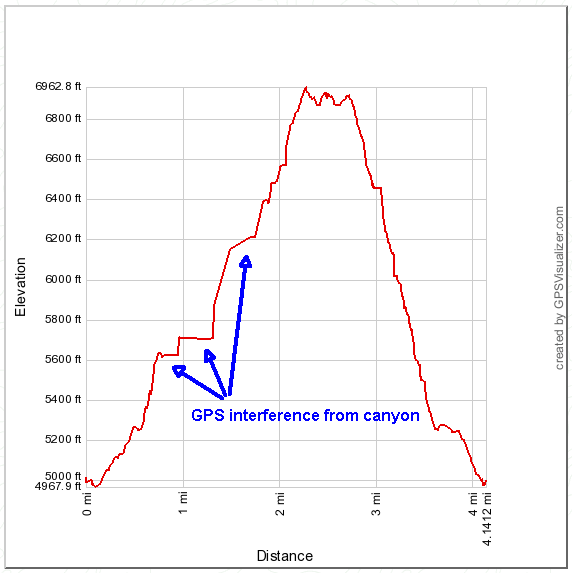
Distance: 4.1 miles round trip on trail and cross country
Summit Elevation: 6927'
Prominence: 244'
Elevation Gain: 2000'
Elevation Gain (in Empire State Buildings): 1.60
Round trip time: 2 hours 55 minutes
Recommended water: 64 oz.
Parking/Fees: Adventure Pass
Difficulty: Moderate
Sugarloaf Peak stands in the shadow of Mt. San Antonio in the San Gabriel Mountains. There are so many mountains named Sugarloaf, it requires identifying each one by location. The route to this Sugarloaf starts at Ice House Canyon, but quickly veers off trail up Falling Rock Canyon. It is a short, but steep 4.1 mile round trip scramble to the summit. Many people continue up the canyon to Ontario Peak, but Sugarloaf was my only target for the day, having been to Ontario in July.
After leaving Ice House Canyon Trail and crossing the creek, you start the steady climb up Falling Rock Canyon. You quickly come to the 1st dry waterfall, a class 3 affair I down climbed on a previous misadventure. It is easily bypassed following a use trail on the left. The next half mile is stiff class 2 bouldering, heading up the canyon. There is a lot of debris, dead fall, and sticks to avoid, or use as leverage to help yourself climb. A number of cairns are arranged, but navigation is not really hard. Just stay in the canyon and choose rocks over loose dirt when given a choice.
At around 6250', you can see the 2nd dry waterfall ahead. Exit the canyon on the right and climb the talus field to the saddle. The talus field is also marked with cairns and a use trail that fades in and out. Like the canyon, I tried to stay in the center of the field and watched where I stepped. After getting to the saddle, the use trail became more clear and headed up the ridge. There was still a little scrambling to do over two false summits before reaching Sugarloaf.
I browsed through the summit log, spotting a couple of names I recognized, then signed it with vengeance for Rod, Terry, and I for our previous bloody trip up the Sugarloaf ridge. The summit offers nice views of the surrounding mountains. The city was completely obscured by a marine layer that went all the way to the foothills. I spent about 10 minutes on the top looking around before heading down. The return trip was slow on the talus, but picked up a little once I got back into Falling Rock Canyon. I avoided the waterfall again on the way down. My GPS beeped several times on the way up, losing satellite link and creating some odd lines on the map and elevation profile. I finished in just under 3 hours.

Panorama from Sugarloaf. From left to right, Mt. Baldy, Harwood, Thunder, Telegraph, Timber, and Ontario Peak.


No comments:
Post a Comment