Saturday, May 27, 2017

Coyote Mountain

Hiked: 5/21/2017
Distance: 5 miles round trip on use trail and cross country
Summit Elevation: 3192'
Prominence: 1592'
Elevation Gain: 2650'
Elevation Gain (in Empire State Buildings): 2.12
Round trip time: 3 hours
Recommended water: 52 oz.
Parking/Fees: Free on Rockhouse Trail
Difficulty: Moderate

I drove to the east side of Coyote Mountain (SDC #71), near Borrego Springs, to hike the main southeast ridge route. I took Rockhouse Trail, a good dirt road that can be driven with a sedan, and parked off the road with quick access the ascent ridge. I expected a steep, non-technical ridge walk. I got that, but I also got an unexpected challenge in the form of an extreme headwind blowing from the north. It didn't start that way. I headed out cross country toward the ridge a little before sunrise, but there was already plenty of light to see. A breeze blew, but nothing seemed out of the ordinary with the wind. A short distance up the ridge, I found a good use trail to follow. As I passed the second bump on the ridge, the wind roared to life. It blasted head on at a steady 30-40 mph with gusts in the 60+ mph range. The wind speeds are just my estimates based on other experiences I've had. This was easily the most savage wind I had encountered on a mountain.

The trail climbed quickly and views into Clark Valley and surroundings expanded proportionally. Across the valley was the long ridge to Villager and Rabbit, and the rest of the Santa Rosas. The ridge was mostly clear of obstacles, though there were always several varieties of cactus nearby. The sun illuminated the summit like a beacon before the rest of the mountain got sun. I stayed on the use trail, except in spots where it clung to the edge of the ridge. That's where the wind was the strongest. On one of these sections, a gust caught me slightly off balance and toppled me, my left hand coming down on a small cactus. I pulled it away with half a dozen needles. I stayed down and crawled just below the ridge, stopping on a boulder to remove the needles with my pliers. I tried to stay about 15' down slope of the ridge to try to minimize the wind. It didn't help much. I couldn't hear myself breathe or hear anything other than the wind. Every step forward was an act of will. I briefly considered turning around, but it was early and I didn't think I would be going near any areas of cliff exposure. I decided to just power my way up. Slowly, deliberately.


Coyote Mountain from the start


The first two bumps


The summit beacon


About half way, summit far left


Looking back into Clark Valley

I kept going over bumps on the ridge until the summit was in view. A leaning pole marked the summit and the register was under a pile of rocks there. A few feet away was the Coyote benchmark. I took some pictures and a 360 video. I didn't disturb the register, fearing that it would blow away or get damaged by the wind. The benchmark photo was enough for me. The views were fantastic and it was sweet to stand on the summit, knowing that I overcame the wind conditions. The wind was not nearly as much of an issue during the descent. It would still gust and was still strong in naked areas, but having the wind at my back made a big difference.
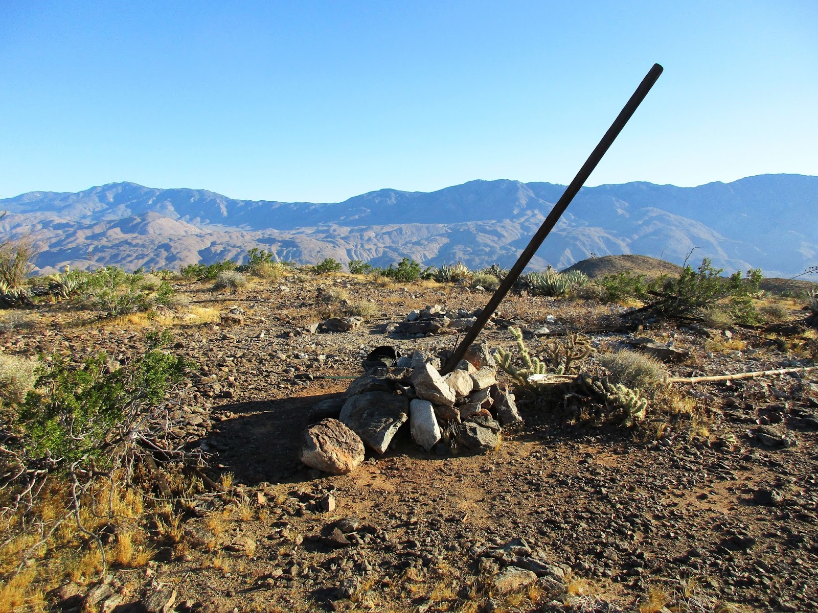


Summit


Toro Peak


Benchmark


On the way back through Borrego Springs, I drove out to the Desert Art display of metallic sculptures. They were impressive, especially the dragon whose body goes under the road. I would have liked to find a coyote among the sculptures, but I think there were some I missed. Definitely worth a visit if in the area.


Coyote Mountain from Borrego Springs


Would you like to know more...?

Sunday, May 21, 2017

The Sinks and Peak 1775

Hiked: 5/21/2017
Distance: 10 miles round trip on trail
Summit Elevation: 1775'
Elevation Gain: 1270'
Elevation Gain (in Empire State Buildings): 1.01
Round trip time: 3 hours 15 minutes
Recommended water: 36 oz.
Parking/Fees: Free at Augustine Staging Area (registration required)
Difficulty: Moderate

Irvine Ranch Conservancy manages 40,000 acres of open space in eastern Irvine. The area is closed to the public except for docent led events and occasional open access days. The gem of Irvine Ranch is The Sinks in Limestone Canyon. The Sinks is sometimes hyped as the "Little Grand Canyon" of the OC. To register for events, go to letsgooutside.org. I have generally avoided the Irvine Ranch area because, sometimes, they are a bit heavy handed in their management. I decided that it was worth the effort to see The Sinks at least once so I signed my wife and I up for a cardio hike that went past it.

Out of 25 people that signed up, only 4 showed. There were 3 guides so we ended up with essentially a private guided hike. After the first mile on Limestone Canyon trail, the group seemed to be relatively strong, so the guides suggested we take the Sandtrap trail for a loop over Loma Ridge. It was more gain, but gave us great views back into the Open Space, the Santa Anas, and the ocean (through some haze). We kept a brisk pace up to the ridge, taking only one break for water and photos. The trail passes over Peak 1775, the high point on the ridge. On the way down, we stopped to look at a raptor nest before reaching the west viewing platform for The Sinks. Here we took about a 5 minute break for photo ops. I admit my expectations were low, but the The Sinks were an impressive product of erosion for Orange County. The way back was mostly flat, gradually losing about 350' in elevation. The highlight on the way back was a large red tailed hawk at the top of a tree. Counting all breaks, we still averaged over 3 mph over 10 miles. Not a bad workout, though my heart rate was only high during the uphill sections.


Two of our guides, CJ and Ali


Start


The Santa Ana Mountains from Loma Ridge


Hawk's nest


The Sinks


On the way back


Red tailed hawk


Sunday, May 14, 2017

Hawkins Ridge

Hiked: 5/13/2017
Distance: 11.5 miles round trip on trail and cross country
Summit Elevation: 8505' (Middle), 8047' (Sadie), 7783' (South)
Elevation Gain: 3450'
Elevation Gain (in Empire State Buildings): 2.76
Round trip time: 6 hours 30 minutes
Recommended water: 92 oz.
Parking/Fees: Adventure Pass at Crystal Lake
Difficulty: Moderate

The Hawkins family is a cluster of 4 peaks near the center of the Angeles National Forest. Mt. Hawkins (8850') is the highest and farthest north, the other three, Middle Hawkins, Sadie Hawkins, and South Mt. Hawkins, lie along a north-south ridge. Leisa and I had done Mt. Hawkins and Middle Hawkins before. Madison was celebrating his birthday and planned a route to start at Crystal Lake, hike up to Windy Gap, then the PCT to the Hawkins Ridge Trail, then descend the ridge going over these summits:

1. Middle Hawkins
2. Sadie Hawkins
3. South Mt. Hawkins

That would complete the Hawkins family for both Madison and I. Sean had done all of these summits several times. Recent rain and a cold front left us in doubt about the conditions we might face on the north slope section of the PCT. I decided to bring microspikes and poles, but leave the ice ax at home. This turned out to be fine and in fact, we encountered no snow on the trail. It was very cold, though, and my preparations for the cold came up short. About 15 minutes into the hike, Sean and Madison stopped to shed a layer. I kept all my clothes on and was quite comfortable. When we reached Windy Gap, the wind howled from the north. I pulled my balaclava on for face protection and Sean and Madison both added back some protection they shed below. We took a short detour to Little Jimmy Spring so Sean could refill some water bottles. Then, we returned to the PCT and headed up toward Hawkins Ridge. The wind was relentless and there was no protection or avoiding it. Madison had stowed his gloves and considered stopping to get them back out. But he didn't, he just toughed it out. Sean considered adding a bandanna for face protection, but didn't. I was in good shape except my fingers started getting cold. I considered getting out my mitts for wind protection, but didn't. A bad mistake. When we reached the Hawkins Ridge Trail, we stopped for hydration and food. It was during this stop that several of my fingers went numb.


Starting on the Windy Gap trail


Looking up at Windy Gap


Madison and Sean at Windy Gap, Islip ridge behind


Little Jimmy Spring


Crystal Lake basin from the PCT


Middle Hawkins from the PCT


Hawkins Ridge trail junction

Cold. I hate it. I am overly sensitive to it. The forecast was low 40sF for South Mt. Hawkins with a 15 mph wind leading to a wind chill of 39F. But, when I pulled up to the Crystal Lake parking lot, the temp was 36F, suggesting a temp on South Mt. Hawkins around 29F. At higher elevations on the north side of our loop on the PCT, it was going to be even colder. The gloves I wore had no wind protection, but I brought mitts for that purpose. The decision not to use them during the worst of the wind led to the numbness. Whether the mitts would have completely prevented it is unknown. As we climbed Middle Hawkins, the wind still blasted us from the north, and there was little relief on the summit. Sean and Madison weren't having any issues, but my fingers were causing me some distress. I finally put on my mitts and dropped chemical warmers in each one, but was not content to wait. I told Sean my hands were cold and that I wanted to continue moving. Without waiting to discuss it, I started moving down the south side of Middle Hawkins and followed the trail toward Sadie. Sean and Madison remained behind to sign the register and take care of other summit business. I flexed my fingers continuously and gripped the warmers. Middle Hawkins was high enough that it blocked the wind once I was below it. That was crucial. Soon, I was at the base of Sadie and started up. The vigorous activity, warmers, and lack of wind made a difference and feeling slowly oozed back into my frozen fingers. When I reached the summit of Sadie, I had feeling back and paused to wait for Sean and Madison. I took no photos between the Hawkins Ridge junction and Sadie. I had no desire to stop and couldn't have operated my camera anyway. During the whole episode, only my fingers were an issue. I need to figure this out or abandon the idea of ever climbing something really cold like Mt. Hood. When Sean and Madison reached Sadie, Sean placed a new register on the summit. We then headed to South Mt. Hawkins as a group.


Climbing Middle Hawkins


Looking back at Middle Hawkins and Mt. Hawkins


Sean's fresh register on Sadie Hawkins


Baldy from Hawkins Ridge


Approaching South Mt. Hawkins


At the base of the South Mt. Hawkins ridge trail

The wind was now gone and the sun warmed things up quickly. We hiked through a beautiful section of new and old pine forest. Hawkins Ridge, like the Twin Peaks and Waterman area, is in my opinion, the nicest part of the ANF. We had a very pleasant hike to the final Hawkins, taking the ridge instead of the road to the summit. Great views unfolded as we topped out and I relaxed for the first time. We sat around, ate, drank, and barely noticed two other people that made the summit from the road. We all roamed around taking photos, then started down the road. Instead of taking the road all the way, Sean suggested a "shortcut". He pointed out a faint use trail down a steep slope. It didn't take much convincing before we decided the shortcut was the way to go. The first part was a scree slide. We lost and found the use trail several times before arriving at a clearing that others had also found. Sean packed out some beer bottles and cans strewn around the area. We dropped down a second steep slope and intersected the Tototngna Loop Trail. That trail led us back to the cars.


Twin Peaks East (right), Triplet Rocks and Smith Mountain


Sean took this shot of us getting ready to head down from South Mt. Hawkins


Looking back at South Mt. Hawkins


Sean leading us down his shortcut


Trail back to the parking lot


Would you like to know more...?