HPS Star Emblem Peak
Hiked: 2/2/2018
Distance: 19.2 miles round trip cross country, use trail, and trail
Summit Elevation: 3480'(Pyramid), 3320'(Marble), 5000'(Rosa Point), 5320'(Mile High), 5756'(Villager)
Elevation Gain: 7107'
Elevation Gain (in Empire State Buildings): 5.68
Round trip time: 14 hours 45 minutes
Recommended water: 212 oz.
Parking/Fees: Free at Villager trailhead on Highway S22
Difficulty: Very Strenuous (combined)
The weather was favorable for a partial traverse of the Santa Rosa range crossing five peaks, four of them on the Sierra Club San Diego Peaks list. The plan was to start at the Villager trailhead, ascend Smoke Tree Canyon to the major ridge, then hit five peaks in this order:
- Pyramid Peak (SDC #62)
- Marble Peak (Unofficial)
- Rosa Point (SDC #28, DPS #67, HPS #281)
- Mile High Mountain (SDC #24)
- Villager Peak (SDC #12, HPS #208)
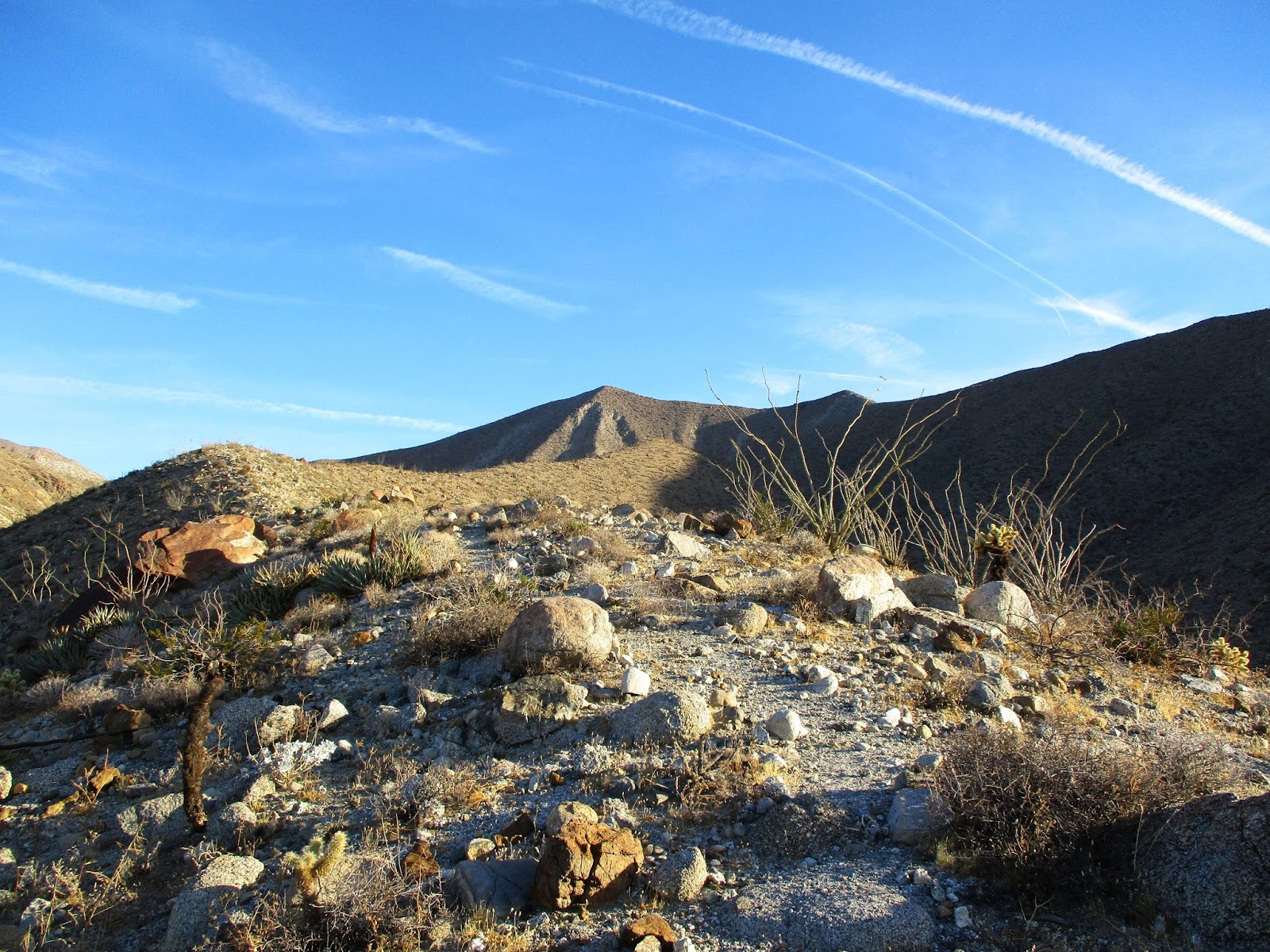
The descent would be down the long Villager ridge back to the open desert and the truck. Short winter days meant I had to start and finish in the dark. If things didn't go well for whatever reason, I had a bail out plan after Rosa. I decided to back load the night hiking, figuring it would be easier to follow the VIllager trail down than ascend a canyon. I started at 5:45 AM, an hour before sunrise covering the mile or so up Palo Verde Canyon to the Smoke Tree Canyon split. There was enough predawn light that finding Smoke Tree wasn't a problem. The entrance is a short class 2 scramble and the canyon itself was mostly clear of obstacles. Not far up the canyon, a use trail appeared on the south side making travel easier. I made enough upward progress when the sun rose to get some nice views during the golden hour. I made a short side trip to the Natural Rock Tanks, interesting formations that held water most of the year. Despite the lack of rain, there was water in the first tank I visited. Back on the trail, I finally got a look at Pyramid Peak. The trail hit the major ridge south of the summit and it was an easy finish. The first small victory provided a fantastic panorama of Travelers Peak below and the Salton Sea. The most recent register entry was from Gus Safar's group that did a Traveler's to Villager traverse only 5 days earlier. I would see their names in all the summits to follow. I did not find a benchmark.
 Climbing out of Smoke Tree Canyon
 Golden hour
 One of the natural rock tanks with water
 Pyramid Peak
 Travelers Peak and Salton Sea from Pyramid
 Rosa Point, imposing and distant
I dropped off Pyramid on the connecting ridge for the short hike to Marble Peak. Marble is an unofficial bump with marbled granite stripes. It was marked in Peakbagger but was unnamed on the topo map. It might have been a 100' diversion from the trail to climb it, where I discovered no benchmark and no register. Next was the long 1700' climb to Rosa Point, one of the toughest sections of the day. Several large bumps were in the way and it's hard to see the connecting ridges. The trail did a nice job avoiding unnecessary gain but faded in and out on the climb to the saddle below Rosa. A short cluster of summit rocks held two registers. An old register started in the mid-1980s was in the double cans. It looked fragile so I only looked at the first few pages. A more recent register was in a magnetic, waterproof pouch. I hunted around the long flat summit until I found the benchmark. It was about 100' southeast of the summit rocks in an open, flat area. I marked it as an unnamed waypoint in my GPS track for future hikers. From Rosa, great views opened up into the southern part of Clark Valley and Pyramid looked like a distant memory far below. Rabbit Peak was dominant to the northwest, but only the tip of Mile High Mountain was visible over the many large protrusions in the way. I was feeling good so far and took a break. If I had the time, I would have basked on the comfortable summit rocks, but time was not on my side. I headed due west to catch the connecting ridge toward Mile High.


 Rosa Point summit rocks
 Salton Sea from Rosa Point
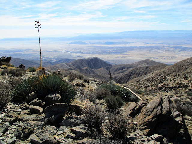 Looking back at Pyramid Peak
After slogging over a few false summits, I spotted Mile High Mountain. The terrain above 5000' started to change. Pines and junipers grew here along with other shrubs missing from the lower desert slopes. Plants and trees were still sparse so none of it impeded forward progress. It was still desert, just a little greener. After dropping off Rosa, there was about 800' of gain to Mile High. The trail wound around and through the rocky outcrops on the final ridge. There were three registers on Mile High Mountain, but no benchmark. I sat down for a longer rest here before facing the climb to Villager's unending ridge. Rattlesnake Canyon spread out below. Beyond the Villager ridge, Coyote Mountain stood in isolation with the San Ysidro Mountains rising further behind. Rested and hydrated, I followed the use trail that led down from the summit toward the saddle below. The first half of the 1100' descent was steep but easy. The last half was a scree slide. While inconvenient, it was certainly much easier going down the scree than it would have been going up. At the saddle, the use trail faded out but it was obvious which finger of the ridge to ascend. The traverse from Mile High to the Villager ridge was the second testy section of the hike and the steepest of the day. It gains about 1000' in half a mile. The footing was mostly good with vegetation and grass keeping things in place. Most of the ascent was class 2 with some class 3 outcrops. Most of the class 3 was avoidable, but it was usually easier to climb the outcrops than navigate around them. Oddly, I stumbled over a white baseball cap someone lost on the way. I gathered it for later disposal. At some point below the ridge, I starting running low on energy and required frequent breaks. The climb started to take on a different mood and became more work than fun. 100 steps, rest 10 seconds, rinse, repeat. I was relieved to reach the main ridge and stunned by the expanse of Clark Valley.
 On the way to Mile High Mountain
 Pink cholla
 Villager Peak from Mile High
 Rattlesnake Canyon
 Villager looming large
 The saddle between Villager and Mile High
 Ascent finger ridge
 Looking back at Mile High
It had taken longer than I wanted to reach this point, but I was energized again by the scenery. I turned north to tackle the final mile and 500' gain to Villager Peak. The trail was well defined and the pines and junipers more common. It was almost lush compared to the stark terrain that came before. At the Villager summit, I quickly dug into the ammo box that held many registers and signed after the Gus Safar group again. Though Villager is only 5756', it felt ten thousand feet high. I understood why this peak was so popular. I didn't celebrate long because the sun was already far along a downward arc. I wanted to get as far down as possible since the night is dark and full of terrors. At sunset, I stopped to unpack lights (headlamp and flashlight) and take inventory. I was behind schedule, a mile in the air and 5 miles from the truck. Worse, I was dehydrated and down to 8 oz. of water. Despite drinking two bottles of water on the drive to the trailhead, I hadn't brought enough. None of the bars or food I had left was appealing, but I forced my self to eat something to power the descent. Thankfully, the trail remained clear and well defined. I was moving just under 2 mph in the dark but it seemed to drag. I kept checking the GPS as it ticked down each painful tenth of a mile. My knees, hips, and lower back all complained from accumulated minor insults, yet I shambled along. I thought I would be back at the car by 7:00 PM. When that time came, I was still 3 miles out, watching tiny car headlights below dance along the S22. I had cell service so I texted my wife to let her know I was fine, but 90 minutes behind schedule. I finished the last drops of water but couldn't force down any more food. Along the way, I became vaguely aware of cliffs on my right. A gaping abyss hid what I suspected were striking views. When I reached the car, I sat down to guzzle two bottles of water before starting the drive home. It was a
solid black pin hike. I arrived home at 11:00 PM to end a 20 hour day.
Everybody's looking for the answers
How the story started and how it will end
What's the use in half a story, half a dream?
You have to climb all of the steps in between
-- Prince, The Ladder
 Approaching Villager Peak
 Villager summit
 Clark Valley
 The endless ridge down
 Good night, Mile High
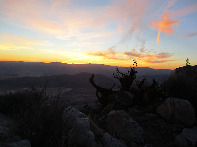 Twilight's last gleaming
 Wrecked
Pyramid-Villager Loop from Keith Winston on Vimeo.
Other Trip Reports:
Pyramid-Villager Loop (Ben Baumann)