Sunday, July 30, 2017

Angels Landing, UT

Hiked: 7/30/2017
Distance: 5.2 miles round trip on trail
Summit Elevation: 5793'
Prominence: 430'
Elevation Gain: 1500'
Elevation Gain (in Empire State Buildings): 1.2
Round trip time: 2 hours 40 minutes
Recommended water: 40 oz.
Parking/Fees: $30 National Parks (per vehicle, one week pass)
Difficulty: Moderate

Angels Landing is one of the iconic hikes in Utah's Zion National Park. It is famous for its knife edge ascent at the end protected by chains anchored to the rock. The summit juts into the middle of Zion Canyon for spectacular views, though many think the views from Observation Point are the best in the park. There is exposure in a few places along the route, with thousand foot drops on both sides. Quick tip #1: don't bother reading the report at Medieval Hiker, it's incomplete. ;)

My wife and I got to the shuttle stop at 6 AM to catch the first shuttle into the canyon but there was already a line. We didn't make the first shuttle and had to wait for the second. We got off at The Grotto, and started up the trail with several parties ahead of us as the sun started to brighten the canyon through overcast skies. A sign at the beginning warned that seven people had died on the route since 2004. They don't mention that more people have died on the short Emerald Pools hike. As we walked along the edge of the river, a herd of deer crossed from the other side. Wildlife in the park is quite comfortable with people. The first set of switchbacks climbs steeply up to a saddle at the entrance to Refrigerator Canyon. A flat section cuts between giant red walls. Then the trail climbs the famous Walters Wiggles set of switchbacks, ending at Scouts Lookout at 5,367'. There are great views into the canyon from there.

Sidebar on crowds:
At peak season, don't believe the rangers when they tell you that the wait for a shuttle is never more than 15 minutes. Late morning and early afternoons, expect to wait 45 minutes to get in and at least 30 minutes to get out. People are overwhelming the system and it really detracts from the experience. I expect the NPS to implement a reservation system and/or lotteries in the future to handle the crowds.


Angels Landing at the start


Deer in the river


Fawn


Towering walls


First set of switchbacks


Refrigerator Canyon


Walters Wiggles


View from Scouts Lookout

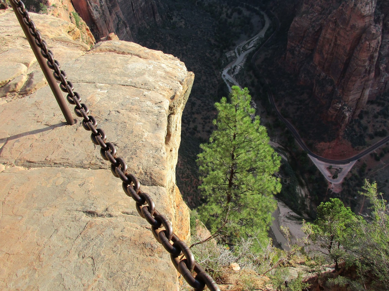
From Scouts Lookout, the chain assisted section to Angels Landing starts. It gains another 426' in about half a mile. Roughly 3/4 of the route is chained, meaning about 1/4 of it is not. Quick tip #2: use rubber coated gloves for extra traction on the chains. I used the same gloves as on the Half Dome cables with great success. At least half a dozen people commented to me that they should have brought gloves for the chains. Leisa followed me up the first chained section, but was not comfortable continuing on the unchained sections. The holds were good, but there is serious exposure on both sides and if you haven't spent much time scrambling exposed routes, it can be unnerving. We wished each other well, and I continued past the first bump. There was a brief descent to the "Leap of Faith" where a short gap in the chains leaves you unprotected on the knife edge ridge. The hiker in front of me wanted me to take his picture there and he reciprocated. Finally, I approached the last couple of hundred feet of gain. There was a mix of class 2 and class 3 scrambling here, most protected with chains, but some not.


Angels Landing behind


Here we go...


On the Leap of Faith


Big drop on this unchained section

I think the NPS did a good job placing chains in the toughest areas. In addition, steps were cut into many sections of sandstone making the whole thing easier and safer. At the summit plateau, there is a short walk along the flat ridge to reach the end. The highest point is probably not at the end, but an 8' craggy rock that I scrambled over on the way back. I took some photos and video at the summit, accidentally catching someone proposing to his girlfriend, who accepted. He joked that he was glad he didn't drop the ring. A fun moment. The descent was clogged with a steady stream of hikers. I had to stop many times to let others pass. The crowding problem creates additional risk for everyone. Fortunately, there were no accidents this day. When Leisa and I got back to the trailhead, we decided to walk the extra half mile to the Zion Lodge. Along the way, we almost crashed into another deer, grazing from the trail. We also passed some wild turkeys. The wildlife went a long way to soothe my over exposure to humans in Zion Canyon. When we arrived back at the visitor center, the line to get a shuttle into the canyon was at least a 30 minute wait.


Final ascent


Looking back at the traverse and the group behind me


Looking north


The summit plateau


On the summit, looking south


Unobstructed south view


Returning


Another deer grazing along the trail


Wild turkey


From Observation Point (stock photo)


Rough trail path, GPS track had a lot of errors

Would you like to know more...?

Other Trip Reports:
Angels Landing Winter Ascent - Adam Walker

Friday, July 28, 2017

Willis Creek Narrows, UT

Hiked: 7/28/2017
Distance: 5.7 miles round trip on trail and cross country
Summit Elevation: 5985' (at the trailhead)
Elevation Gain: 300' (down then up)
Elevation Gain (in Empire State Buildings): 0.35
Round trip time: 2 hours 35 minutes
Recommended water: 32 oz.
Parking/Fees: Free at BLM500/Skutumpah Road
Difficulty: Easy

Willis Creek is a non-technical slot canyon near Grand Staircase Escalante National Monument. The drive from the north requires a 5 mile stretch of dirt road. The road is in good shape and doesn't require 4x4 or high clearance. There are three creek crossings and after rain, it might not be possible to get there. We arrived late morning minutes after another family. The trailhead parking lot is large and can accommodate more than a dozen cars. Flash flood danger is minimal since you can climb out of the canyon in most places. It was also Parker's birthday, so I wanted him to enjoy the outing.

The trail starts directly across from the lot. We followed the other family to the canyon drop in point. At first, we tried to avoid the steady stream of water, but the alternative was mud. We quickly learned that walking in the water was more stable than slipping around in the mud. The water was never more than 6-7" deep. The first slot section came early, followed by a 10' waterfall with a trail bypass on the right. In the second slot section, we all got comfortable working in and out of the water and passed the other family that started with us, who had still not learned to stay out of the mud. The kids were really having fun. A couple more slot sections included some nicely grooved walls and another one with high black walls.


Dropping in


First slot


Bypassing the waterfall


Groovy walls

About a mile from the start, the slot sections ended and the canyon widened out with sharp walls on only one side. It would have been easy to exit the canyon any place past the slots. As we passed a 15' boulder in the middle of the creek, my daughter challenged me to climb it. It looked like straight forward class 3 but my wet, muddy shoes were a problem. I used two underclings and one foot hold to reach the top. It was a little dicey on the descent as my feet slid around, but I made it down safely. We continued all the way to the end of Willis Creek where it feeds into Sheep Creek. We stopped at the end of the creek and sat down on a log for water and food. The return trip seemed to go faster. Shelby was ready to get back to the car and she set the pace upstream. The weather had held up, but on the way back we spotted dark clouds on the horizon. When we got back into cell range, we all got flash flood warnings, but were well out of harms way by then. It was a really fun hike and highly recommended for families. Who knew a 12 year old boy would enjoy splashing around in water and mud.


Black rock slot


Weird cupped walls


Using an undercling


Success


End of Willis Creek at Sheep Creek


The one waterfall on the route


There is a storm coming


Boat Mesa, UT

Hiked: 7/28/2017
Distance: 1.5 miles round trip on trail and cross country
Summit Elevation: 8076'
Elevation Gain: 438'
Elevation Gain (in Empire State Buildings): 0.35
Round trip time: 1 hour
Recommended water: 0 oz.
Parking/Fees: Free at Fairyland Point
Difficulty: Easy

Boat Mesa separates Fairyland Canyon from the rest of Bryce Canyon. It is a dominant structure in the north part of the park. There is no formal trail to the top, but I scoped out the northwest ridge next to the rim trail that looked like it would work. I couldn't tell if the ridge ended in a cliff just below the plateau. The only way to find out was to go up. This was a daybreak solo mission before we attempted Willis Canyon later in the day. I parked at Fairyland Point, which is outside the Bryce Canyon gate. There is free but limited parking.

A few other early birds were at Fairyland Point waiting for sunrise. When the sun did come up, it was behind a large dark cloud muting the golden effects it might have cast on the hoodoos. By then, I had already left the rim trail and was half way up the ridge. To my surprise, I found a pretty good use trail. It was easy going to the summit plateau where the use trail ended and a dozen animal trails cut through small trees and shrubs. There were great view points on the east side into Fairyland, but views to the west into Bryce Canyon were mostly obscured by trees. I suspect most people stopped at the plateau, but my quest was to find the high point. It would have been impossible without a GPS. The plateau rises 5' or 10' feet here or there and some light brush is in the way. I wandered around the high point, eventually zeroing in on the indistinct spot with no markers. A small pine tree occupied the high point. Once the mission was accomplished, I tried to get a better look down the west side cliffs without much success. I returned down the ridge and was back to the car in an hour.


Looking up at Boat Mesa from the east


Looking up at Boat Mesa from the west


Climbing the ridge


Summit plateau


Limited view to the west


Better view to the east


Summit pine tree