Hiked: 9/25/2022
Distance: 3.4 miles round trip on trail
Summit Elevation: 8044'
Elevation Gain: 875'
Elevation Gain (in Empire State Buildings): 0.7
Round trip time: 1 hour 30 minutes
Recommended water: 16 oz.
Parking/Fees: $35 National Parks Fee
Difficulty: Easy
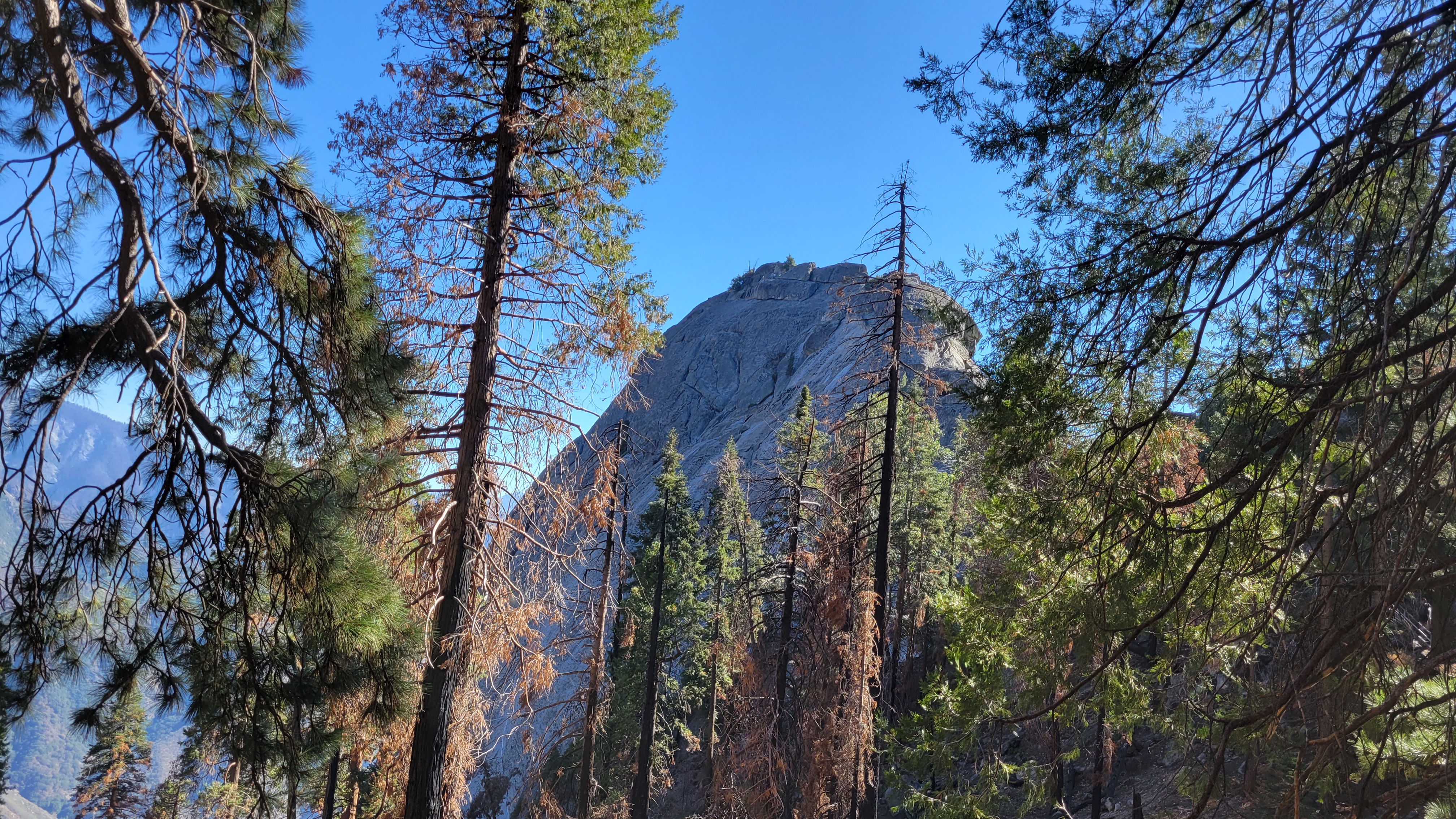
Little Baldy is in Sequoia National Park and can be reached from an easy trail that starts at a turnout off the Generals Highway. We started near the end of the golden hour and enjoyed the glow on the evergreens as we gained elevation. Signs of the last fire that raged through were evident, but it was less damaged than the area around Big Baldy. Views were also better than on Big Baldy, not just because we had better weather. Little Baldy is situated closer to the other big mountains and the great western divide. The whole mountain was charming. A benchmark graced the top, along with some kind of solar powered weather/comm station. The summit dome was large and sloped down gently a great distance before reaching a drop off. It looked like it could be climbed without difficulty from the south ridge, worth a try if we ever get a chance.
Hiked: 9/24/2022
Distance: 13.3 miles round trip on trail
Summit Elevation: 8973' (Watchtower), 9577' (Pear Lake)
Elevation Gain: 3496'
Elevation Gain (in Empire State Buildings): 2.8
Round trip time: 7 hours 20 minutes
Recommended water: 100 oz.
Parking/Fees: $35 National Parks Fee
Difficulty: Strenuous
Leisa and I drove to the end of Wolverton Road and started up the Lakes Trail. Alta Peak starts at the same trailhead, but you continue on to Panther Gap instead of staying on the Lakes Trail. The lower part of the trail is shaded and soft, something we appreciated on the way back. About 1.6 miles in, we took the fork to stay on the Lakes Trail, and shortly thereafter came to the fork with the Hump trail. To reach the Watchtower, stay left on the lower trail. The Hump trail is a bypass for winter conditions. It adds unnecessary gain and misses the incredible views along the Marble Fork of the Kaweah River.
The Watchtower is a granite prow, splintered from the rest of the mountain and only 300' off the main trail. At the last switchback before the top of the ridge, we continued on a use trail. A group of three was in front of us, and we followed them up a wide, class 2 crack. The summit was a small pile of boulders above that. We waited for the other group to finish their photos and climb down. The summit boulders were a relatively easy scramble, though the final mantle move I rated class 3. Most people stayed on the trail and looked over the gap at the Watchtower. We marveled at the view, then climbed down. The trail past the Watchtower was carved out of the cliff. While never narrower than 4', some hikers might be nervous at the precipitous drop along this section.
The group in front of us on the class 2 crack
Watchtower summit boulders
Leisa on the Watchtower
The first lake we reached was Heather Lake. We took a short detour to visit the shore where several groups were resting or fishing. We pressed ahead another mile to Aster Lake. The trail circles Aster. Emerald Lake was south, along a separate short trail, but was not visible from the main trail. On the north side of Aster, we considered taking a break, but decided to soldier on the last mile to Pear Lake. The final mile of the trail was more rocky, with big 18" and 24" steps. It also had some gain. We finally relaxed at Pear Lake with campers and multiple groups milling about. Pear was nestled below Alta Peak and surrounded by granite walls. It was the nicest lake of the three. The water was cold, but probably as warm as it ever gets. A few people were wading in shallow water and a couple brave youngsters took a dip. None of them stayed in the water for more than a minute. We had a leisurely lunch before returning the way we came.
Hiked: 9/23/2022
Distance: 1 mile round trip on trail
Summit Elevation: 6725'
Elevation Gain: 350'
Elevation Gain (in Empire State Buildings): 0.2
Round trip time: 40 minutes
Recommended water: 16 oz.
Parking/Fees: $35 National Parks Fee
Difficulty: Easy
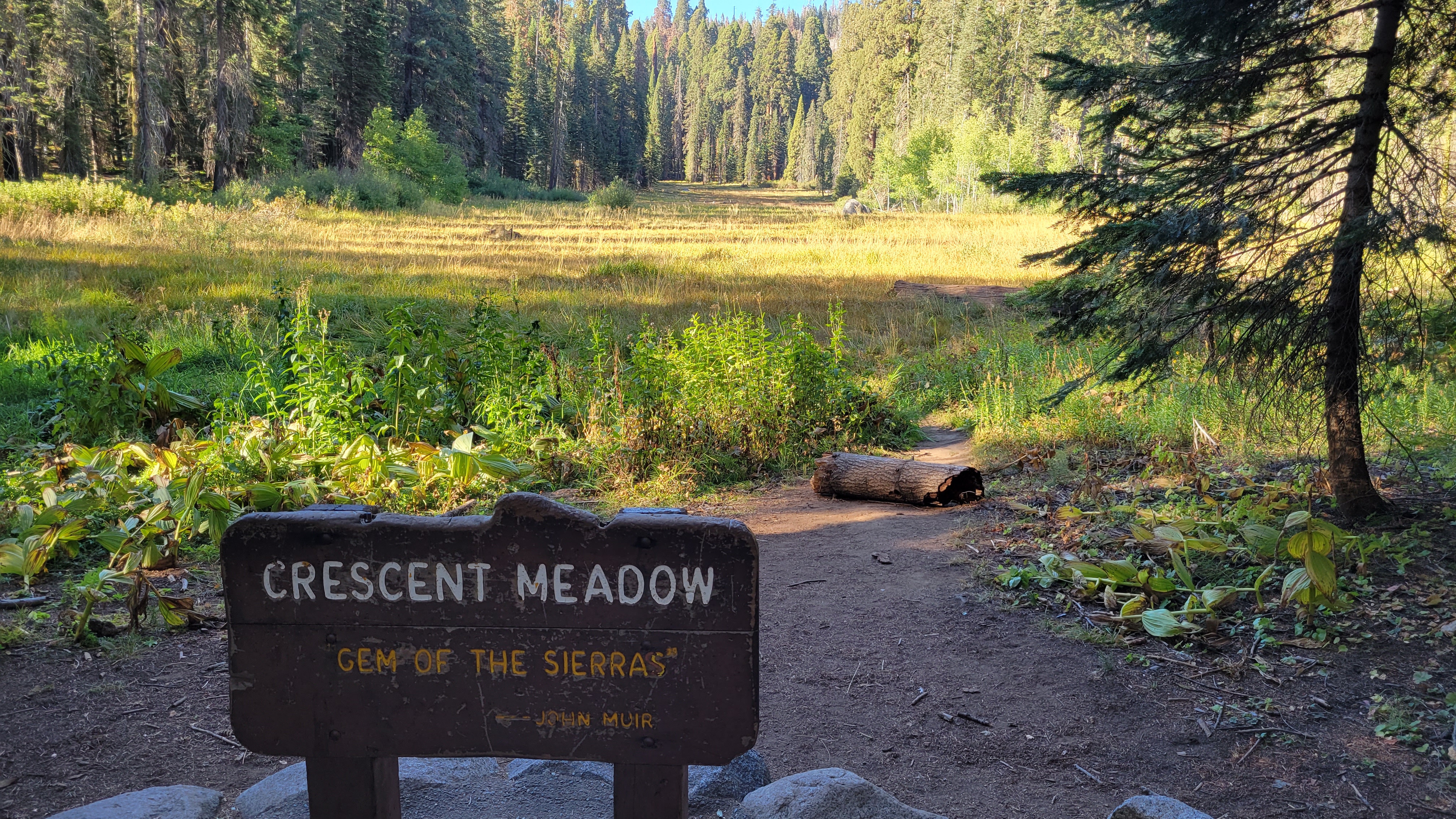
Leisa and I returned to Sequoia National Park to finish the things we missed on our abbreviated trip earlier in the month. (note: stats are just for Moro Rock. We also hiked more than a mile around Crescent Meadow, and more than a mile to Sunset Rock. I combined all of these short trips into one report.)
Moro Rock is a massive and prominent rock that is visible outside the park. It's a popular attraction and during summer, can only be reached by shuttle bus. The season just ended so we were able to drive to it, though we had to park in an overflow area. A half mile hike got us to the base, then we took 300' of stairs to the top. Without the stairs, it would be a formidible rock climb. There were nice unobstructed views on top and several information plaques.
Silliman left and Alta Peak right
Next we drove to Crescent Meadow and planned a loop by Tharp's Log and the Chimney Tree. A small crowd was gathered a hundred feet down the trail watching a mama and baby bear scavange for food. The mama was easy to spot digging on the ground, but it took us a minute to spot the baby 100' up a tree. Whatever the baby was doing up there, it was done, and started to descend tail first. We watched it all the way down, losing track of the mama, but guessed it had moved away from the gawkers since that is the way the baby ran. When we got to Creascent Meadow, it was hard to enjoy since dozens of gnats had joined our hike. I put on my bug net and Leisa followed suit later. Tharp's Log was a makeshift cabin built into the root end of a fallen Sequoia. It had a table, window, and rock chimney. Per Wikipedia, the log is named after Hale D. Tharp, who was described as the first Non-Native American to enter the Giant Forest. John Muir described it as a "noble den". Our last stop on the loop was Chimney Tree, a Sequoia whose inside was burned out, leaving a hollow husk and long shards of bark that could fall at any time.
Leisa in the entrance to Chimney Tree
Our last hike of the day was to Sunset Rock, a 1.4 mile round trip from the Giant Tree Museum. It ended on a granite slab with an NPS benchmark overlooking the valley toward Three Rivers. It was a nice way to end the day, but we headed back just before sunset. Instead of camping this time, we stayed at the Wuksachi Lodge, highly recommended if you want a comfortable room inside the park.
Hiked: 9/3/2022
Distance: 13.8 miles round trip on trail and cross country
Summit Elevation: 11188'
Prominence: 828'
Elevation Gain: 4866'
Elevation Gain (in Empire State Buildings): 3.5
Round trip time: 10 hours
Recommended water: 160 oz.
Parking/Fees: $35 National Parks Fee
Difficulty: Strenuous
Leisa and I camped at Lodgepole Campground in Sequoia National Park with several hikes on the agenda. We drove up on the 2nd and I realized I had left my hiking boots at home. Uh oh. It was the start of a series of SNAFUs. After setting up camp, we drove to Fresno where I picked up some boots at REI. Not a relaxing start to the weekend. Packing for the hike the next morning, I realized the fresh batteries I installed in the GPS were dead. Also dead was my flashlight and I couldn't get it open. I still had a headlamp, if needed, but things were already going wrong.
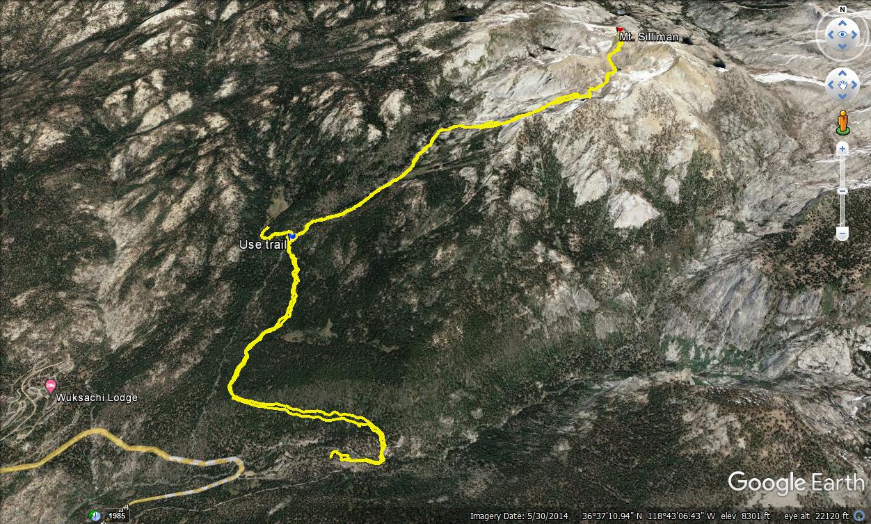
We walked 0.2 miles across the campground to the Twin Lakes trailhead. I hadn't done much research on Silliman (SPS #201), expecting it to be similar to Alta Peak we had done the year before. We were heads down hiking on the smooth trail, then a GPS check showed we had passed the exit point to the use trail. We gave up some elevation to return to the use trail that started behind a sign at the Silliman Creek crossing. The trail shadows Silliman Creek on the east side (right). Water was running in the creek and with Silliman Lake ahead, we weren't worried about water. Downfall plagued the use trail, but it was otherwise in good condition. When we reached Silliman Meadow, we had not gained much elevation, a bad omen leaving most of the gain packed into the final two miles.
Use trail starts behind the sign
Silliman behind the distant sub-peak
A wide granite basin loomed above the meadow. The use trail led into chest high bushes with faint paths traced in multiple directions. Leisa and I both had GPS tracks, but different ones. Mine led toward a cliffy gully on the right. Hers led toward the basin on the left. We followed mine until the way forward was unclear, then we backtracked and followed hers. That got us through the bushes and onto the slabs. The slabs were wide and chunky, similar to the slabs on Sub Dome. Ascending required switchback moves to reach the next ramp. The sideways movement put too much pressure on Leisa's still healing toe. With 1900' of gain left, she decided to return to camp. She encouraged me to continue, and persuaded me that she could find her way back with her own track. I stayed with her until she got off the slabs and watched her blend back into the bushes. Ignoring the GPS, I went straight up. Near the top of the slabs, I met a fat marmot who had no need or interest in any food I might have.
Through the bushes
The granite basin
On the slabs
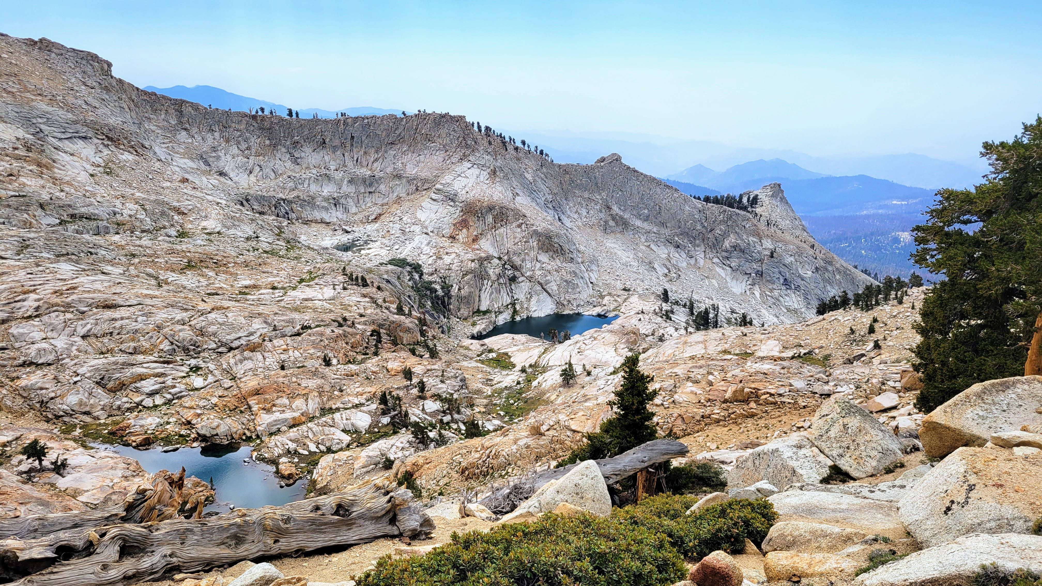
Silliman Lake was blue green and glassy in a bowl of rock. The way up was through a grass filled gully and a series of ledges. Nothing exceeded class 2, but route finding was important. Soon, I reached a smaller unnamed lake I called Upper Silliman Lake. Although I wasn't low on water, I decided to fill up my one liter filtered bottle. It was a nice place for a break before the last ridge. While I was resting, a couple approached from the other side. They were Joe and Christie Alfano from Wuksachi. They asked if I had been up Silliman before, and I learned this was also their first attempt. They had come up the gully right of the slabs. They continued up along a visible use trail. I wrapped up my break and followed, catching them before they got out of sight. None of us was moving quickly, but my pace was slightly faster. The rest of the route was a mix of sand and class 2 boulders.
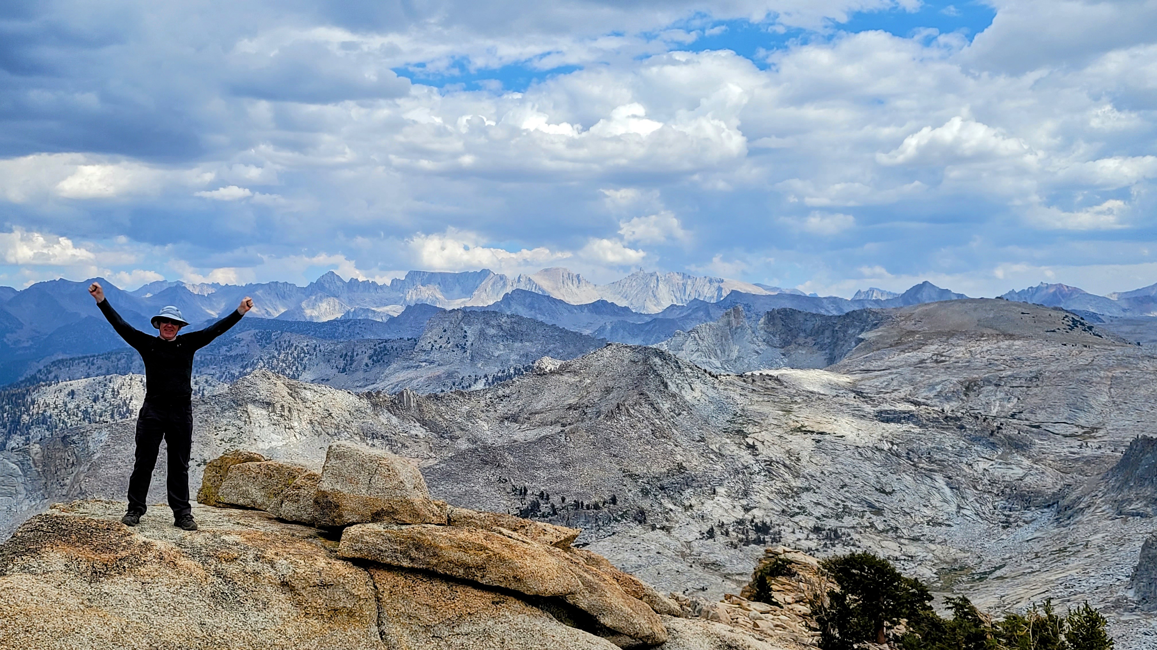
I arrived at the summit about 10 minutes before the Alfanos. The views were fantastic in all directions with big drops on the north and east sides. Wind gusted around the top and dark clouds had silently built up in the afternoon, even though the forecast was for sunny skies. I found a benchmark and signed the register. When the couple arrived, we took photos of each other and shared well wishes before I started down. The clouds were concerning, and I might have heard lightning as I passed below the lake, but wasn't sure. In any case, I was well below the high point and felt safe.
I followed the track I had down the gully. It appeared cliffy, but always revealed a workable path. Eventually, I reached the bushy area, then the meadow. The heat rose back to 80F as I descended. Gnats annoyed me just before the main trail so I put on my bug net until they gave up. I had plenty of water but was hot when I got back to camp. I was greatly relieved to find Leisa made it back, and impressed with her ability to navigate back alone. She did get a nasty cut on her leg from climbing over fallen trees. I walked to my truck to sit in the AC for a few minutes and was shocked when it barely started. I let it run for 10 minutes, then tried to start it again. It took several tries before the engine turned over. We discussed our options and since it was late, decided to camp another night and hope it started in the morning. There was no cell service for hours, we didn't have jumpers, and our options were few. If the truck didn't start, we might be stuck for days trying to get help. The next morning, we packed up camp and crossed our fingers. The truck started on the third try. There were no warning lights, so I guessed it was just the battery. We drove to Visalia, found a Pep Boys, and left it running while I went inside. With luck, they had the right battery and installed it in less than an hour. We debated whether to drive up to Sequoia again for one more day, but decided to return home and not dare the gods to deal us any more bad cards.