Hiked: 5/23/2014
Distance: 15.2 miles round trip on trail and cross country
Summit Elevation: 6733' (Cobblestone), 6841' (Sewart), 6253' (White Mountain #2)
Prominence: 1373' (Cobblestone), 401' (Sewart), 850' (White Mountain #2)
Elevation Gain: 6360'
Elevation Gain (in Empire State Buildings): 5.08
Round trip time: 10 hours 15 minutes
Recommended water: 248 oz.
Parking/Fees: Adventure Pass
Difficulty: Very Strenuous
One of the toughest day hikes in Los Padres National Forest, Cobblestone (plus Sewart and White) was a hike inspired by a post on the San Gabriel Mountain forum by David Stillman. Cobblestone is probably the most remote HPS peak in Ventura County. It is an off trail, yucca filled, waterless, destination with more than a vertical mile of gain. The hike is an all day commitment, and even savvy, experienced hikers run out of water by underestimating it. I had elaborately planned the trip for late April, but discovered Alamo Mountain Road was closed seasonally and would not open until mid-May. In May, I kept calling the Mt. Pinos Ranger station until I confirmed the roads were open. Unfortunately, the new hike date lost some of the original group and it ended up being just Sean and I. We met at the Verdugo Park and Ride, then Sean drove north and navigated the 24 miles of dirt road mazes to the trailhead. You can't even start this hike without a serious effort. As an added challenge, I was suffering from a serious sinus infection, the kind that makes your face and teeth hurt. I had visited the doctor the night before and he put me on Azithromycin, a big dog antibiotic. I was one day into my five day treatment when I faced Cobblestone. Other than having to blow my nose every 30 minutes, the sinus infection didn't cause me undo distress.
We started down the trail at around 8:00 AM, about an hour later than planned. There was a horrific crash on the I-5 that delayed me, and the dirt roads took longer to navigate than expected. I could not have made it in my low clearance vehicle, some of the ruts were too deep. We started at Buck Creek trailhead toward the first milestone, Sewart Mountain. The weather was pleasant, having cooled down from triple digits the previous week. Cobblestone is immediately visible from the trailhead, and looks much closer than it is. Heading up Sewart was a constant battle with large deadfall blocking the trail. Some you could get around, more you had to climb over. Both sides of the mountain were filled with deadfall obstacles. We spotted three deer right away, and a fourth later bounding across the slopes. They were all too fast for us to get photos. Coming down the east side of Sewart, we made the first of two big navigational mistakes. We bushwhacked directly toward the ridge, but the path required getting to a saddle between Sewart and the ridge first. We figured it out about half way down and traversed over to the saddle. On the way, I tripped on some brush and hit my hand on a rock. It didn't seem like much at the time, but I learned later I had a bone bruise in the metacarpal of the small finger on my right hand. It got worse as the day proceeded, but in the heat of battle, I just continued. There were a lot of discarded bottles and cans on Sewart and between us, we packed out about 8.

Cobblestone from the Buck Creek trailhead, farther than it looks

Sewart from the Buck Creek trailhead

Sean signing the Sewart register

Deadfall on Sewart Mountain
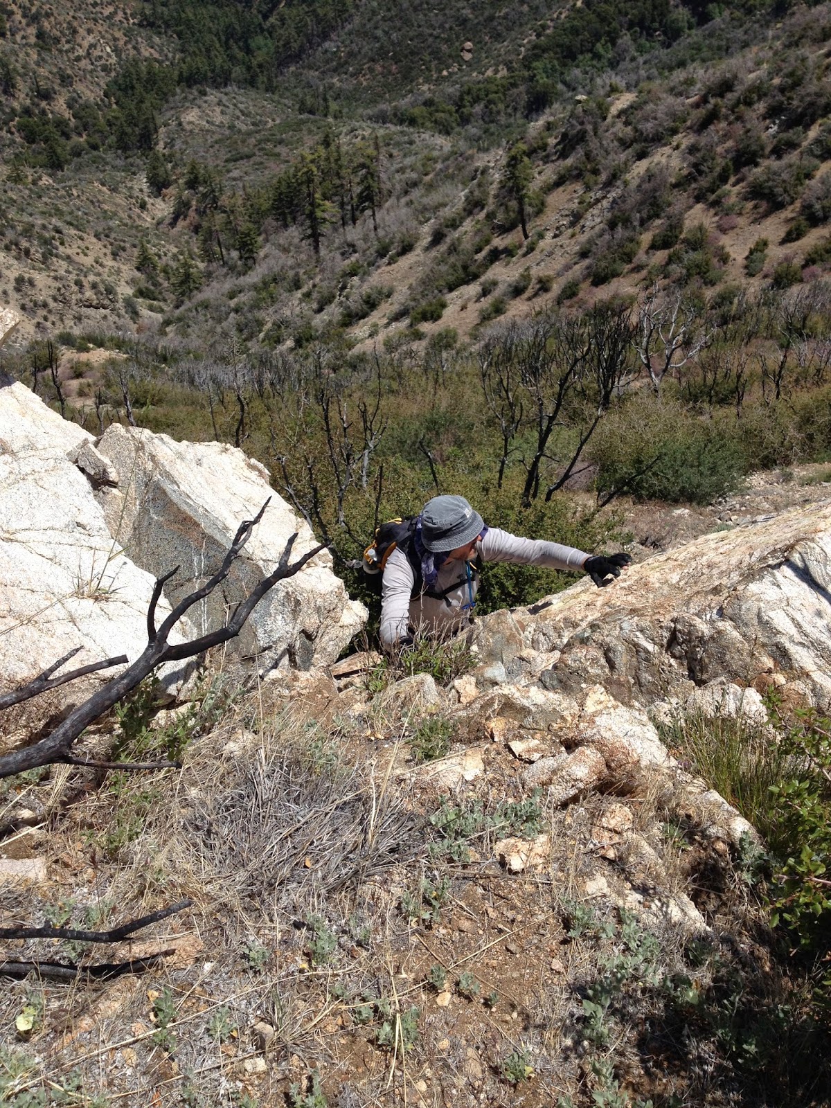
At the saddle, we took David Stillman's advice and cached some water at the bottom of Sewart, cache #1. This turned out to be great advice because at the end of a long day, the thousand foot climb up Sewart is tough and would be beyond miserable without water. I took 248 oz. (>7 liters) of water and used every drop. We immediately continued the climb to White Ridge. The trail was in better shape along the ridge. In about two miles, we found an old wooden sign that said "Stewart Mountain 3 1/2, Alamo Mountain 8". Apparently Sewart used to be named Stewart or the sign was a misprint. [Update: According to the USGS, it has been named Sewart since 1/19/1981] Sean spotted an overgrown use trail behind the sign that appeared to descend toward the saddle between the ridge and Cobblestone. We decided to give it a shot. The trail was overgrown in spots and washed out in spots, but very usable. It made the descent to the Cobblestone saddle a non-event. At the saddle, we cached more water, cache #2, and Sean decided to drop his pack, taking only one liter and energy bars for the ascent. I continued carrying my pack up Cobblestone.
Heading up the saddle, we found some ducks and tape to lead the way. Still, there were unmarked sections where we drifted and the 1400' climb in less than a mile was at 30 or 40 degree angles. There were cool "cobble" like rock formations along the way. The ridge along Cobblestone is open and sandy, and we were glad to reach the summit for an extended break. The aluminum register from 1960 still looks brand new. Entries go back to 1981. I flipped through to find people I knew, Bob Burd, and both entries from David Stillman. I took a good look down "Redrum Ridge" and it looked very unfriendly. I don't want to go there, Mrs. Torrance. We signed the register, and after taking in the remarkable views, went down at an exuberant pace. This is where we made our second navigational mistake. We drifted left of the major cliff area and came out a good distance from the saddle. We decided to cross country just below the cliffs to get back to the saddle. The dirt was so loose that we frequently would slide 5 feet down the slope and have to scramble back up, only to slide again a few steps later. The brush was thick in places and forced us lower and farther away from the cliffs than we wanted to go. Eventually we fought back up to the saddle and retrieved cache #2.

Rare shaded area along the White Ridge

Old sign for "Stewart" Mountain and Alamo, use trail to Cobblestone saddle starts behind it

Coming down the use trail to Cobblestone saddle

Descending to the saddle between White Ridge and Cobblestone

Cobblestone boulder on Cobblestone Mountain

Baby pine in the burnt forest

Cobblestone benchmark

Dedication of register box to Jack Cross

Fancy aluminum register box on Cobblestone summit, secured to the rock

View southeast from Cobblestone summit

White Mountain and ridge from Cobblestone summit

Sean on Cobblestone summit

Checking the summit register
The next decision was how to get back up to the White Ridge. We considered a direct ascent, but that held little appeal. Instead we chose to side hill toward White Mountain following deer trails. We eventually reached the spot we were aiming for, but it turned out to be a good 200' below the ridge. We started angling higher, more directly toward the ridge and I led us up a short, but completely unnecessary section of class 3 rock for fun. We quickly headed down the lupine filled ridge toward White. As we got closer, it once again became a deadfall obstacle course. Poodle dog bush crowded some sections. We passed over two false summits on the way to White and I stopped on one to eat some snacks for much needed energy. The summit register was a glass jar inside the standard red cans. The views are great in some directions, and partially blocked by brush in others. We only rested a few minutes before starting back along the ridge line. It was mostly pleasant coming back along the ridge, but the gain was far from over. Two major sections offered 500' and 200' climbs before descending back to the saddle below Sewart, where we collected cache #1.
At this point in the day, Sewart looked like a monster. We decided to stick to the trail along the overgrown road for the final 1000' slog. Again, as you reach the midway point on Sewart and for the rest of the way, you are fighting the deadfall. I finished my last drop of water as we reached the car. This was a mild day with temps never reaching much over 70F. On a hot day, I would have needed at least 300 oz. (about 9 liters). Cobblestone left me with plenty of bruises, scrapes, and bumps, and a swollen hand for about a month, but also images of a beautiful, isolated pine forest, burned but recovering, and big peaks to challenge your resolve. Special thanks to David Stillman for valuable beta while preparing for this hike.
Unnecessary, but fun, class 3 section ascending to White Ridge

Same short class 3 section

Heading to White Mountain through a lupine meadow along the ridge

White Mountain register

Cobblestone from White Mountain summit

Dead giants


Would you like to know more...?
Other Trip Reports:
Cobblestone Mountain (David Stillman)
Strong work man. That peak is cast iron. -ds
ReplyDeleteThanks again for the advice, David. It was all the challenge I wanted and more. Seeing the names in that aluminum register really left me with a feeling of accomplishment.
DeleteThank you for including Jack Cross in your blog about Cobblestone Mtn. He was my dad. He loved biking, hiking, and the wilderness, a gift from God. He enjoyed organizing group activities for the Sierra Club Santa Barbara Chapter. He died, when I was an infant, of a brain tumor. I've yearned my whole life to know him. When I marvel at and are surrounded by God's majestic natural beauty around our area, I know my dad is nearby enjoying the scenery, too. Thanks again for his inclusion in your blog. Hike on!
ReplyDeleteMeghagen,
DeleteI appreciate the kind words. Your father was a pioneer and an inspiration. His memorial is in a very special place in the wilderness where his legacy can be preserved. I wish I could have known him, too.
From the saddle between Cobblestone and White mtns hike a little ways west. On the south side there is a creek with drinkable water
DeleteLarry,
DeleteInteresting. I see a creek there on the topo map that looks like it feeds into Agua Blanca, but I was under the impression it was usually dry. Thanks for the tip.
Did White and Cobblestone from Buck Creek many years ago. Very tough
ReplyDeleteUnknown,
DeleteAgree!
What a incredible area. Looks stunning!
ReplyDeleteShane,
DeleteI'm not sure my photos even do it justice. Cobblestone is really special. When driving north on I-5, you can see it in the distance. Very hard to reach from any direction.
That whole area is something else. Went up there a few days ago without enough water and learned my lesson the hard way. Really nice trip report, looked like an awesome day.
ReplyDeleteShirt and Tie Adventures,
DeleteYeah, no water anywhere on the route, and I went through over 7 liters. I was glad to have cached a lot for the return trip. It was a memorable day. You'll get it next time.