Hiked: 1/28/2022
Distance: 6.8 miles round trip cross country
Summit Elevation: 3723'
Elevation Gain: 2000'
Elevation Gain (in Empire State Buildings): 1.6
Round trip time: 4 hours 30 minutes
Recommended water: 64 oz.
Parking/Fees: Free on dirt road behind Chiriaco Summit Campground
Difficulty: Moderate (route finding, scramble)
I've been interested in the untouched wilderness in Joshua Tree National Park just south of Eagle Mountain. There are several compelling peaks that appear to be unclimbed, or at least there are no documented ascents. There is also a rectangular area of jagged rock formations that are visually stunning and extremely remote. Places like this draw me like magnets. While researching the area, I noticed John Morrow had created a provisional peak in Peakbagger called "Oasis Peak", the topo map labelled it 3723'. He likely named it after nearby Lost Palms Oasis, a destination Leisa and I visited just weeks ago. There were no attempts in Peakbagger. There were no attempts listed in Listsofjohn.com. There was no attempt by Bob Burd. I suspect it might have been climbed earlier since it is only 3.5 miles from I-10, but until I can find evidence, I'll claim the first ascent!
I drove north from the Chiriaco Summit exit on I-10, past the General Patton Museum, and past the dry campground to a turn around at a gated dirt road into Joshua Tree. I am not sure an entrance fee applies here, but I had a National Forest annual pass and I carried it with me. It would be a rare bit of luck to run into a park ranger in this area. I mapped a route using Caltopo to follow a wide drainage north, then gain the ridge at a low saddle at 2600'. On the map, it looked like straight up the ridge was best, but route finding led me to the north side of the ridge in many places. The approach was sandy and easy. There was an elevated shelf east of the main wash and it was thick with dangerous cholla. I stayed off this shelf until I had to cross it. The short climb to the lower saddle was easy.
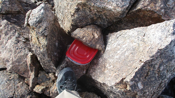
Terrain after the saddle was mostly class 2, with some class 3 near the top of the ridge. There were two false summits along the ridge until I saw the true summit at the end of the ridge line. After passing the second false summit, it was a walk up. Two small piles of boulders competed for the high point, but the one at the very end of the ridge was slightly higher. That's where I placed a register in a plastic sandwich box. Like on Orocopia, the wind was screaming. I had to hold my hat down even though it was strapped under my chin. I got a great look at the "Wrecked Tangle", even more jagged from a closer perspective. Fantastic scenery all around. I searched for any kind of mark but there was nothing. I started back the same way, though I drifted low along the north slope too early. I think my ascent line was cleaner. I took a break half way down to rest and appreciate where I was. I noticed something metal in the middle of the cholla forest and diverted my return slightly to investigate. It was the shell of an old car set up as some kind of shelter. Next to it, I found 3+ gallons of water stored in barrel. My guess is it was shelter for migrants. It didn't look like an official park service waypoint. I left it as it was and returned along the wash. As a safety note, I didn't have cell service at Chiriaco Summit or anywhere on the hike. Cell service was not available to call for help in this area. I got back to the truck right at sunset. I'll end with a quote from Ryan Holiday: "The obstacle is the way".


Looks bueno. Congrats on the first ascent.
ReplyDeleteThat def looks like a migrant water drop, although a bit paltry.
Who knew there was an airstrip at Chiriaco?
The Wrecked Tangle looks cool. Wonder if it's accessible from the Mastodon Peak side.
Madison,
DeleteThe wrecked tangle is definitely accessible from the Mastodon side. I've studied the satellite views quite a bit, but need to map out the best route(s). I think less gain from Mastodon and somewhat easier at the end.
So doable in a day? Or is it an overnighter?
DeleteGetting there and back is doable in a day. Eagle Mountain, the high point there, took me 7 hours, and this would be less gain. My main interest is the center tower, but there are at least 4 big towers in there. If rope is required, it gets much tougher as a day trip.
Delete