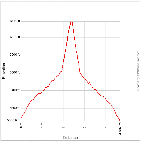
Hiked: 10/2/2015
Distance: 4.7 miles on trail and use trail
Summit Elevation: 6193'
Prominence: 1313'
Elevation Gain: 1140'
Elevation Gain (in Empire State Buildings): 0.91
Round trip time: 2 hours 30 minutes
Recommended water: 48 oz.
Parking/Fees: Adventure Pass
Difficulty: Easy
Combs Peak is #4 on the Sierra Club San Diego Peak list. It sits in a strategic location between Palomar and the Santa Rosa range and at 6193' offers outstanding views. To get to the trailhead, turn on Chihuahua Valley Road from Highway 79, when the road makes a 90 degree right turn, continue straight on a dirt road then immediately right on Lost Valley Road, also a dirt road. Continue past mile marker 4 to a turnout on the left where the PCT crosses the road. Lost Valley Road is pretty rough and high clearance is recommended, but not required.
From the trailhead, we made our way up the mellow PCT to the cairn marking the use trail. The entire hike gains about 1140', but half of that comes in the final half mile. The use trail was loaded with cairns, guiding us through shrubs and burned trees. There were some steep, loose sections, typical of the desert peaks in San Diego county. At the smallish summit, we took in fantastic 360 views of San Gorgonio, San Jacinto, Palomar, and the entire Santa Rosa range including Rabbit and Toro Peak. The benchmark was dated 1939. There were three register books, the oldest dating back to 1995. We hung around the top a while and I got a good close up shot of a Tarantula Hawk wasp, then we cruised back down to the cars.
Photosphere from Combs Peak summit


No comments:
Post a Comment