Hiked: 9/18/2015
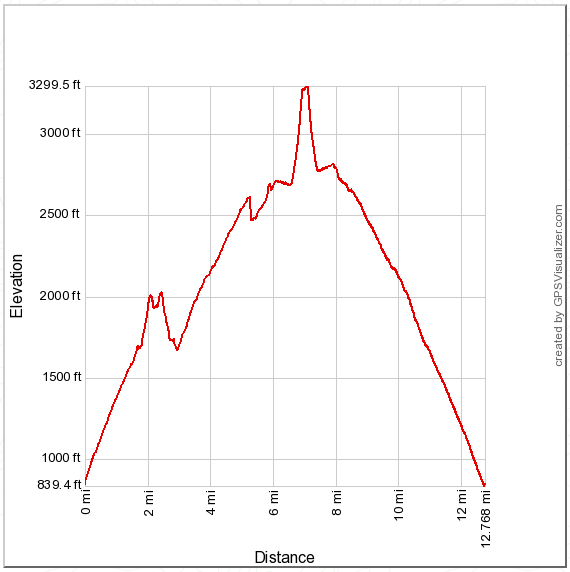
Distance: 12.8 miles round trip on trail and use trail
Summit Elevation: 3326' (Old Sugarloaf), 2040' (Peak 2040)
Prominence: 546' (Old Sugarloaf), 350' (Peak 2040)
Elevation Gain: 3025' (combined)
Elevation Gain (in Empire State Buildings): 2.42
Round trip time: 5 hours 30 minutes
Recommended water: 96 oz.
Parking/Fees: Adventure Pass
Difficulty: Moderate
This was my second trip to Old Sugarloaf in the Santa Anas, but I started from the bottom of the San Juan Trail instead of descending from the top at Blue Jay Campground. The bottom of the trail starts on the right side of Hot Spring Canyon Road. To get there, turn onto Hot Spring Canyon Road at the fire station on Ortega Highway and continue about a mile to a large parking area. The trailhead has a restroom and trash cans.
The trail begins with short, zipper-like switchbacks for the first 300' of gain, then longer switchbacks up to the ridge line at about 1700'. At the ridge line is a junction on the right with the use trail to Peak 2040. I had found the register for 2040, which is not located at the summit, earlier in the year when I hiked up the firebreak. I followed the use trail about a half mile to bag Peak 2040 as a side trip. The trail was slightly overgrown in a few places, but easy to follow. The summit had a small cairn, but the register is quite a bit further at a lookout point above the fire station. I signed the register and saw that only one other person had signed it since my first visit in June. A large hunting knife was left near the register that was not there the first time. On the way back, I got great views of the southern Santa Ana peaks. Old Sugarloaf looked a long way out and I realized I had probably underestimated the length of my hike. While I was returning to the San Juan Trail, I heard some voices. Two mountain bikers had just passed the junction and were climbing up ahead of me. As a popular biking trail, a lot of the San Juan Trail is deeply rutted. This became an annoyance over time. I followed behind the bikers a couple of miles before they pulled away.
The switchbacks and gentle ascent seemed to go on forever. The trail wandered toward Old Sugarloaf, then veered away, then circled back. I got a good look at Los Pinos ridge during this hike and it looked tough, something for another day. Eventually, I got to the use trail for Old Sugarloaf and made my way up. There is only one short and easy scramble near the top, though the entire trail is pretty steep. I signed the register and wandered down the north ridge a little to get a feel for the brush. It was apparent early on that this was not a better way to Tanriverdi Falls. The north ridge was very steep and utterly choked. I loitered around the summit for about 15 minutes before packing up for the return trip. The descent was hot and I had to dodge a couple more bikers flying down the trail. Otherwise, it was uneventful.


No comments:
Post a Comment