Hiked: 2/11/2015
Distance: 3 miles round trip on trail
Summit Elevation: 1375'
Prominence: 380'
Elevation Gain: 790'
Elevation Gain (in Sears Towers): 0.63
Round trip time: 50 minutes
Recommended water: 16 oz.
Parking/Fees: Free on Grand Ave
Difficulty: Easy
Buzzard Peak is the high point of the San Jose Hills just south of I-10 in the Walnut/Diamond Bar area. It also overlooks the Kellogg campus of Cal Poly Pomona. I had attempted to hit Buzzard Peak on 2/6/2015 prior to visiting Vulture Crags (sticking with the scavenger theme), but was thwarted by private property issues from the south on E. Seton Hill.
Satellite research revealed a well defined use trail on the north side starting on Martingail Road. For my second attempt, I headed toward that trail but discovered it is in a gated and guarded subdivision. The guard directed me to a nearby horse trail that he said led to the peak. I followed the horse trail until it became a road that vanished into knee high green foliage. I continued cross country for about a mile before concluding that access was not possible this way without trespassing, so I turned around. On the way back, I remembered a possible access trail on Grand Ave and drove around to the south side to see if I could find it. I located it with a legitimate looking trail sign and parked on the opposite side of Grand, sprinting across as traffic allowed. The sign labelled it as the Schabarum trail.
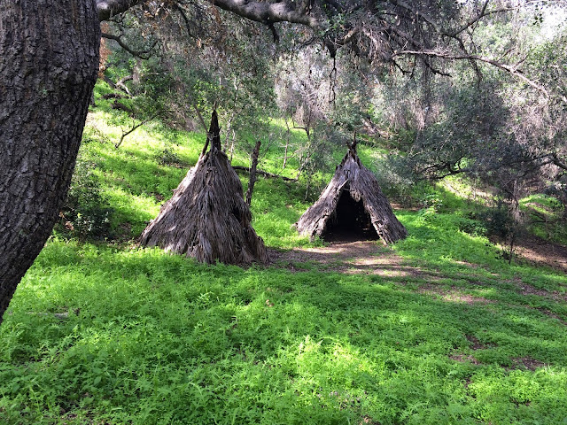
I didn't bother with a pack, only one water bottle and the GPS. The trail starts as a single track then widens into a dirt road, showing recent use by horses. About a half mile in, another road branches right heading up a different hill, so continue straight. The trail descends to a gully passing two unexpected tipis, then gains elevation again as it meets the west end of Buzzard Peak Road. There is a little poison oak along the sides of the trail, but it is easily avoided. The road climbs up the ridge where you get your first look at Buzzard Peak. I headed up the use trail on the south side of the peak and found a reference mark stamped "Covina" and the benchmark itself stamped "San Jose". No register. There were good views of the local mountains. Without fanfare or a break, I descended the use trail on the north side, then returned along the road. Lacking beta and surrounded by private property, this little peak turned out to be rather expensive in terms of time and miles wasted on the north side. For future hikers, I am confident this is a totally legal track. This was my first lunchbagging peak (one I could summit during a work day lunch break).


Bagged it today, Keith. Nice hike. Only one teepee is standing, the other is in ruins.
ReplyDeleteMike,
DeleteI wonder what the back story is with those. I thought Buzzard had very good views for an urban peak.
6-23-2019 Buzzard Pk hike. first of all, you cannot park anywhere on Grand Ave. Nearest parking is a block west on E. Cameron Ave at Heritage Park which opens before 9am & closes at 6pm. Plenty of parking spaces there w/ outhouse. So walk 1/4 mi eastward on Cameron back to Grand Ave and then walk another 1/4 mi up to the trailhead which is across Hillside Dr.
ReplyDeleteAt this time there were 4 to 7 ft tall dried grasses that needed to be bushwhacked especially the first 1/4 mile. There were no Indian teepees that I saw. The trail is mostly visible but once or twice you may end up taking the wrong fork so be on the alert. The final trail up the Peak is around to the north side and then a small trail leads up the east ridge.
I saw 4 plastic folding chairs at the summit. It was like the locals who took them up to see the forth of July fireworks or just to see the sunset. And yes, I did see 4 Turkey Vultures flying close to check on me. Got some neat photos but cannot paste them here.
tokuo
6-23-2019 Correction: #7 photo above should read "Mt Sac Campus" . You can see "MSAC" on the green hill just left of center of the photo. As for Cal Poly campus, only its "Kellogg West Banquet Catering" building may be seen per Google Earth. It is the highest elevated building on campus. But I have not spotted this building from the summit.
ReplyDeleteAnd, as for the "50 min round trip time" , it can be done if the following is neglected: a) no bushwhacking on trail b) no enjoying the flora or fauna c) no checking out the view d) no selfies e) no resting on the summit and taking in the 360 deg view & trying to identify some landmarks f) no phoning friends to say "I've climbed it!" It took me 59 min to do this. On the return trip it took me 45 min to hike down to trailhead and then 10 more minutes to Heritage Parking Lot 1/2 mi away. tokuo
Tokuo Nakamoto,
DeleteThanks for all the updates. I'm not surprised about the heavy undergrowth along the trail after the very wet winter. Other trails I've visited recently have also be overgrown. I did the trip in 50 minutes by jogging most of the way down. I probably spent 2 minutes on the summit mainly looking for the benchmark and taking quick photos. I was rushing because I was on a lunch break. Glad you bagged it!