Hiked: 10/27/2013
Distance: 3.2 miles round trip on trail and cross country
Summit Elevation: 3342' (high point at trailhead)
Elevation Gain: 769' (loss then gain)
Elevation Gain (in Empire State Buildings): 0.61
Round trip time: 2 hours
Recommended water: 40 oz.
Parking/Fees: Adventure Pass
Difficulty: Easy
Update 2/20/2015:
I returned to complete the full trip to Tanriverdi Falls
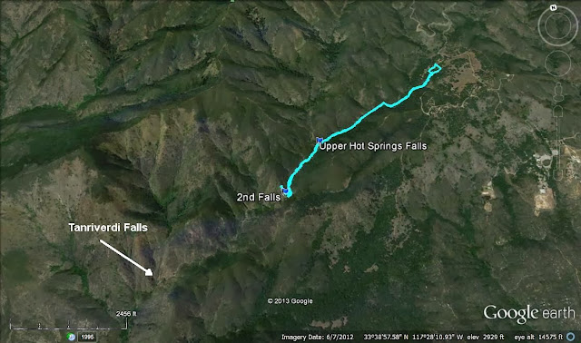
Hot Spring Canyon runs about 9 miles in the Santa Ana Mountains from the Falcon Campground to a ranger station just off the Ortega (Highway 74). The prize in the canyon is the rarely seen 160' Tanriverdi Falls about half way down the canyon. The inspiration for this hike was this trip report and several impressive photo albums. According to the trip report, there are 5 mandatory rappels requiring advanced canyoneering skills. My goal was to see how far down the canyon I could get without equipment.
I parked at the first parking area in the Falcon Campground and displayed my Adventure Pass. I was not sure if an additional parking fee was required to park inside the camp, but I took my chances. Directly across the road was the start of a trail leading to the canyon. Once in the canyon, there is a use trail that runs on the right side, dropping into and out of the canyon at various points. It is somewhat overgrown in a few areas, but not too hard to follow. Los Pinos Peak towers over the canyon and was visible most of the way.
The first real obstacle I ran into was deadfall clogging the canyon. The use trail disappeared and I scrambled over the trees to find the best place through. Returning, I found a place where only one tree can be crawled under but it was not obvious on the way down. Soon, I got to Upper Hot Spring falls, a dry 15' fall that was easy to walk around. The rock leading up to it was an attractive marbled white and gray. Most of the large rocks were worn smooth by water and didn't have much traction, even dry.
The second falls was a show stopper. It was a 30' drop into a shallow pool. There was a path along the cliff that appeared to be a way around, but the rocks were smooth (slick) and a fall would have been catastrophic. I decided not to chance it and head back to look for a higher way around. I found a faint use trail that headed up but soon cliffed out back at the canyon. I backed up further and found another faint trail that went higher, but eventually disappeared. From there, bushwhacked most of the way up the bump above the falls, which was unpleasant, but not impassable chaparral. From that vantage point, I could see it was not going to be easier going down the other side. This route is possible with enough determination, but I concluded I might be able to make an easier run at Tanriverdi Falls by going over Los Pinos and following the trail down to a departure point on the ridge. From the Los Pinos trail, a ridge or gully descent toward the falls would also be an unpleasant bushwhack, but shorter than from the top of the canyon. Another possible approach would be to go down the north side of Old Sugarloaf, more nasty bushwhacking, then ascend up to the falls. Or, do the full slog up the canyon from Ortega Highway, with permission to pass through the private land owned by a church.


No comments:
Post a Comment