Saturday, March 4, 2023

Chuckwalla Mountain

Hiked: 3/3/2023
Distance: 3 miles round trip cross country
Summit Elevation: 3466'
Prominence: 1406'
Elevation Gain: 1575'
Elevation Gain (in Empire State Buildings): 1.2
Round trip time: 4 hours
Recommended water: 64 oz.
Parking/Fees: Free on BLM Road 588
Difficulty: Moderate

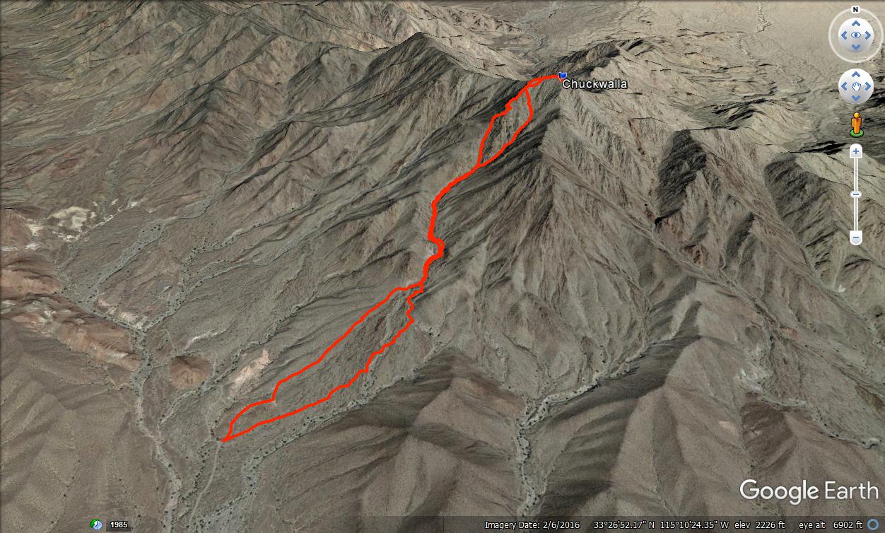
Chuckwalla Mountain (DPS #91) is a very remote desert peak about 20 miles south of I-10. The drive in on Graham Pass Road was long, but the road was in very good shape. There were only a couple of sections that might give a sedan problems. After ~16 miles, I turned north on BLM Road 588. It was only another 1.5 miles to the start. I was the only person at the trailhead. The two main ways to the top are the south ridge and south gully. You have to take the gully about half way, then decide which looks better. I decided to take the ridge on the way up and the gully on the way down. The ridge has a little more scrambling, but all class 2 with some route finding. It was slow going and I found the ridge quite enjoyable.

Long pre-dawn drive

Start

Leaving the gully for the ridge


The summit was sandy and narrow. A register was placed at the top of a pile of rocks at the high point, while the official benchmark was at the end of the summit. The benchmark was stamped "Bunch", matching the topo map. Not sure when/why the mountain was renamed to Chuckwalla. I did see a small chuckwalla hiding in the crack between two rocks, but she was the only one. The previous visitor in the register was in December, 2022, though the register book started in 1992. Views made up for the very long drive. There was a feeling of isolation here. The only sounds I heard were from low flying jets and the distant rumble of exploding ordinance in the nearby Chocolate Mountains Aerial Gunnery Range. I shot some videos, then started down the gully. Going down was no faster than going up. Steep, loose rocks kept me alert until I was near the bottom. I followed the gully a little too far and made a minor course correction at the end. Chuckwalla was fun from the jump. I still had half the day left so packed up and headed off to explore the Little Chuckwalla high point.


Ascent ridge


Descent gully


Thursday, February 9, 2023

Haystack Mountain

Hiked: 2/8/2023
Distance: 10 miles round trip on trail and cross country
Summit Elevation: 3808'
Elevation Gain: 3396'
Elevation Gain (in Empire State Buildings): 2.7
Round trip time: 6 hours
Recommended water: 120 oz.
Parking/Fees: Free at Art Smith Trailhead
Difficulty: Strenuous

We were in Palm Springs for a couple of days while Leisa attended a work conference. I had recently discovered Haystack Mountain in the Santa Rosa foothills. I was still recoving from a non-covid virus, so was moving slowly. The starting point was the Art Smith Trailhead in Palm Desert. The first half mile was through a flood plain with not much of a trail. Other people were also getting a start and I could see them on the trail cut into the hill on the opposite side. There was a nice metal sign at the base of the trail. The trail was well groomed and started up in earnest through rock piles and varieties of cactus. Barrel cactus in particular seemed to love this area and got larger as I went up. I passed a couple of splinter trails that descended to residential areas. About 2.5 miles in, I reached a palm oasis with second one in view. A few hikers were gathered around the oasis, a popular destination.


A little more than 3 miles in, I left the trail and headed toward Haystack, looming above everything else. There were multiple ridge line options, but the second ridge seemed the most uniform. I started north of the major gully and stayed above it on the approach. When I got around it, I had already passed the start of the ridge, so took a sidehill angle to reach it. Dirt on the side of the ridge was loose and I would have been better off starting at the bottom of the ridge. Once I gained the ridge, there were 4 peaklets to overcome. Each had a steep class 2 finish, then the slope leveled off until the next one. The final peaklet was class 3 but had a class 2 bypass on the right. The final mile gained 1300'. When I got off the ridge, it was an easy quarter mile walk up. The summit had a large cairn and a register that went back to 2010. I was surprised how often it had been visited, maybe 10 people a year. A reference mark was at the high point, but the benchmark was 114' away at an overlook. The reason I know that is that the reference mark had the distance recorded precisely. The marks were not placed by the USGS, but by the War Department in 1951, an unusual find. Perhaps that accounts for the precision of their stamps. I found the views on top superlative. San Jacinto and Gorgonio maintained their winter snow coats, but were looking less covered than last month. I spent about 20 minutes on the summit before starting down the same ridge. I continued to the bottom of the ridge and intersected the Art Smith trail around the same spot I left it. The descent confirmed that taking the ridge all the way was best. This hike fell in my sweet spot for difficulty and time. I waffled on whether to rate it moderate or strenuous, but opted for the harder rating based on the cross country and ridge scramble.


Summit


Martinez (left) and Toro (right)

Descending

Final look back from the trail


Sunday, February 5, 2023

Cedar Creek Falls

Hiked: 2/4/2023
Distance: 5.6 miles round trip on trail
Summit Elevation: 1842' (Trailhead)
Elevation Gain: 1190'
Elevation Gain (in Empire State Buildings): 1.0
Round trip time: 2 hours 20 minutes
Recommended water: 32 oz.
Parking/Fees: Free at Ramona Trailhead
Difficulty: Easy

At ~90', Cedar Creek Falls is the highest waterfall in San Diego County. It has become so popular that a permit system was set up to limit the number of hikers on the trail to 375/day. Winter was a good time to go since water was flowing from recent rains and it was cool. We got a lazy start and the parking lot was full when we arrived. We parked on a residential road and walked to the trailhead. Staff was checking permits at the trailhead. There was potable water at the trailhead, and a restroom, but it had a long line. Right behind us was a group of 50 college kids. It took them time to get organized, giving us a chance to put some distance between us before they got going. The hike in was downhill at a gentle grade. Several benches and rest areas were available along the way. The first water crossing was the San Diego River. A group of ten women was on their way back, trying to cross. One had made it and nine we on the far side taking their shoes and socks off. With the swarm of people on the trail, I was in no mood to wait for them to inch their way across. I plodded into the river which was calf deep and crossed in 15 seconds. Leisa was three steps behind me. One woman complained that I spashed her ankle on the way out, but remarkably, she didn't melt. There were two more stream crossings of Cedar Creek. At each crossing were people carefully removing/putting on their shoes, but there was plenty of room to pass. We had dry shoes/socks in the truck and it was easier and safer just wading through. There were about 10 people milling aorund the base of the falls. We took a few photos, then I launched the drone for some aerials. No one even noticed the drone was in the air. Unless it is nearby, you can't hear it, and the light gray color makes it almost invisible. I am glad we made the trip to see the falls flowing, but once was enough.


Saturday, January 28, 2023

Blue Angels Peak, Three Benchmarks, and a Cherub

Hiked: 1/27/2023
Distance: 7.5 miles round trip on dirt road and use trail
Summit Elevation: 4548' (Blue Angels)
Elevation Gain: 2155'
Elevation Gain (in Empire State Buildings): 1.7
Round trip time: 4 hours 10 minutes
Recommended water: 40 oz.
Parking/Fees: Free on Smugglers Road
Difficulty: Moderate (scramble)

Blue Angels Peak is on the US-Mexico border in the Valley of the Moon. It's a rock filled wonderland in southern San Diego County. I exited I-8 at In-Ko-Pah Road, then parked a short distance up the dirt road to Blue Angels. I would have driven further, but the road was deeply rutted, and while my truck was capable, I was less sure about my driving skills. A maze of dirt roads was etched into the hills. On my way to Blue Angels, I was passed by two Border Patrol trucks. I also saw a spotter plane above. In addition to Blue Angels, I wanted to climb three small benchmarks. My itinerary was:
  • Blue Angels Peak (4548', class 2)
  • "Blue Cherub" (4325', class 3)
  • Whip BM (4318', class 1)
  • Nopal BM (4280', class 2)
  • Quirk BM (4031', class 2)
I followed the roads to a use trail leading to Blue Angels. The trail went south of the summit, then came back up the south ridge. The summit blocks were easy and I found a benchmark stamped "Smuggler". Nearby is Smugglers Cave and the area has a history of smuggling. I'm not sure when it became Blue Angels. The register was in bad shape, it needed a ziplock bag and was in a single can without a lid. This peak needs a new register. After climbing down, I walked south to Border Monument 231. Text on the pylon referenced several treaties with Mexico. There was no wall at this part of the border, just a barbed wire fence with the top strands cut. I decided to climb some of the boulder piles on the way to Whip BM, and named the largest one "Blue Cherub". I reached the top using a class 3 ramp that led directly to the summit. Then, I continued on to Whip, a short walk up with a benchmark and a register.


Border Patrol with mad driving skills

Breaking Bad

Blue Angels summit


Valley of the Moon


Ramp to "Blue Cherub"

Looking back from Whip BM

Whip BM summit


From Whip, I descended back to the road and headed toward Nopal BM. The road ended about a quarter mile below the top. A faded use trail led over some boulders and the summit block was easy class 2. I didn't find a register or benchmark on Nopal, but I didn't spend a lot of time searching. The final benchmark of the day, Quirk, was just off the road at an intersection on the way back. Quirk was a 150' mound that could be ascended from any direction. I didn't bother looking for a trail, I just hit it head on. No benchmark or register, but it did have a solar powered transceiver. I had spotted several of the tall black antennas on various local high points along the roads. These were surely for the Border Patrol. Speaking of which, a third truck rolled up while I was on Quirk. One of the agents got out and walked toward me as I was climbing down. He lost interest before I was half way down and returned to the truck. The roads near the border were well patrolled.

Heading to Nopal BM

Nopal summit block

Quirk BM


Saturday, January 14, 2023

Stone Mountain

Hiked: 1/13/2023
Distance: 1 mile round trip on trail and use trail
Summit Elevation: 1860'
Elevation Gain: 385'
Elevation Gain (in Empire State Buildings): 0.3
Round trip time: 40 minutes
Recommended water: 0 oz.
Parking/Fees: Free on Watt Road
Difficulty: Easy

I drove 5 minutes from the Simon County Park trailhead to the start for Stone Mountain. It was a residential street with a horse trail on both sides. The Gunstage Trail circumnavigates Stone Mountain, but to reach the top, find the use trail that starts on the northeast side. I was using Michael Sullivan's GPS Track, but it was obvious from the trail. The use trail was easy to follow and remained clear all the way to the top. It was an easy hike up and I was no longer pushing myself like I was on Spangler. The boulder pile was class 1. I found no marks and no register. Stone Mountain had a wonderful view of Mount Gower.


Start of the use trail

Summit

Mount Gower

San Vincente Golf Club