Distance: 3 miles round trip cross country
Summit Elevation: 3466'
Prominence: 1406'
Elevation Gain: 1575'
Elevation Gain (in Empire State Buildings): 1.2
Round trip time: 4 hours
Recommended water: 64 oz.
Parking/Fees: Free on BLM Road 588
Difficulty: Moderate
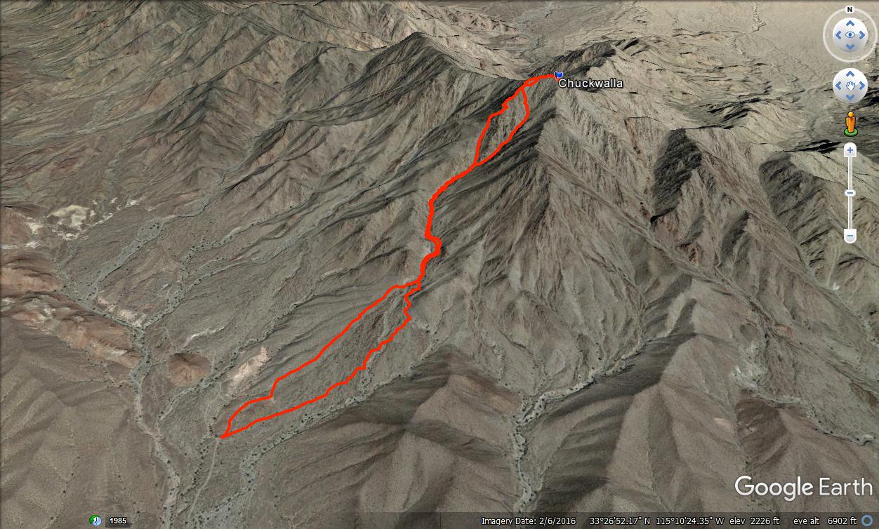
Chuckwalla Mountain (DPS #91) is a very remote desert peak about 20 miles south of I-10. The drive in on Graham Pass Road was long, but the road was in very good shape. There were only a couple of sections that might give a sedan problems. After ~16 miles, I turned north on BLM Road 588. It was only another 1.5 miles to the start. I was the only person at the trailhead. The two main ways to the top are the south ridge and south gully. You have to take the gully about half way, then decide which looks better. I decided to take the ridge on the way up and the gully on the way down. The ridge has a little more scrambling, but all class 2 with some route finding. It was slow going and I found the ridge quite enjoyable.


The summit was sandy and narrow. A register was placed at the top of a pile of rocks at the high point, while the official benchmark was at the end of the summit. The benchmark was stamped "Bunch", matching the topo map. Not sure when/why the mountain was renamed to Chuckwalla. I did see a small chuckwalla hiding in the crack between two rocks, but she was the only one. The previous visitor in the register was in December, 2022, though the register book started in 1992. Views made up for the very long drive. There was a feeling of isolation here. The only sounds I heard were from low flying jets and the distant rumble of exploding ordinance in the nearby Chocolate Mountains Aerial Gunnery Range. I shot some videos, then started down the gully. Going down was no faster than going up. Steep, loose rocks kept me alert until I was near the bottom. I followed the gully a little too far and made a minor course correction at the end. Chuckwalla was fun from the jump. I still had half the day left so packed up and headed off to explore the Little Chuckwalla high point.


Drone footage is incredible, breathtaking--you're not even holding a controller!?! Congrats on the new wheels, too!
ReplyDeleteGloop,
DeleteThanks! Some of the shots were manual, some pre-programmed so you don't need the controller. I got the Tacoma about 2 years ago with every 4x4 option. It has features I probably won't ever use, but are nice just in case.
Thank look pretty good. I like the isolation.
ReplyDeleteSuper isolated. I followed all the safetly rules. 1) I went alone. 2) I made sure I was at least a 10 hour walk from the nearest help. 3) I drove at least 20 miles on dirt roads away from population centers. 4) I was out of cell range. A lot of DPS peaks meet this criteria. Some in the Mojave are just as isolated, and the ones in Mexico.
Delete