Distance: 8.5 miles round trip on use trail and cross country
Summit Elevation: 2491' (highest point in canyon)
Elevation Gain: 1692'
Elevation Gain (in Empire State Buildings): 1.35
Round trip time: 7 hours
Recommended water: 92 oz.
Parking/Fees: Free on Modjeska Canyon Road
Difficulty: Strenuous
Sean, Henry, and I had bigger plans, but were foiled by the USFS closing key roads we needed. Our backup plan was to explore Harding Canyon, and check out what was beyond the main waterfall. I had hiked to the waterfall once. This was a new area for Sean and Henry. This trip was a little more difficult than my first visit because there was a lot more water in the canyon (a good thing). It's a great time to hike Harding Canyon with all the falls flowing. Salamanders and frogs were abundant in and along the many pools. At the main waterfall, we took a break. The water was about knee deep to the base of the left side where it can be climbed. We spent about 20 minutes building a rough rock bridge to the base, then made the class 3 climb. We cleared the 2nd tier and got ready to explore the upper canyon.

One of many small falls and pools


Henry at the main falls
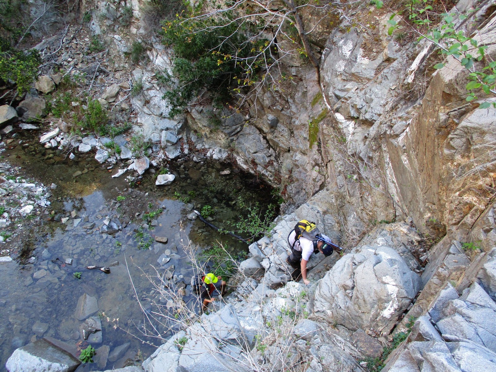
Climbing left of the falls

Above the falls, the canyon was narrower. It started with more rock hopping in the stream. The use trail was gone, the brush grew more troublesome, and the poison oak more abundant. In particular, there were a lot of downed trees, sometimes piled like pick-up sticks from run off. Many of the dead trees were crawling with ants and we had to brush them off frequently. We continued about a third of a mile beyond the main falls. We passed many more small waterfalls and large boulders. It was very nice, but we didn't discover any new spectacular attractions. We stopped at a fall where the scrubby continuation would have been rather unpleasant. On the return trip, Sean and I both found unattached ticks. With a warm afternoon, I expected to meet a snake or two on the way back. Sean was the only one who spotted a snake on the trail, but it slithered off before he got a good photo. I had thought about placing a trailcam in the upper canyon, but the lack of animal trails or signs of anything larger than a lizard dispelled that idea.

Immediately above the main falls

More falls, more pools


Nasty pile of ant-covered trees

Small fall where were turned around


Above Harding Canyon Falls from Keith Winston on Vimeo.

See also:
Harding Canyon Falls
Like minded! I tried going back there a couple years ago in the summer and turned around right about where you did. Above the falls gets gnarly right at the first corner! My main goal for Harding is to eventually get to 33.725367, -117.574037, which looks like a huge multi-tier waterfall and possibly a convergence with an a smaller falls, which I have heard roaring from above on HTT after heavy rains. I'm also curious if there are any damn Big Cones left up there...I'd think in that grove we both fell a bit short of. Can you tell I'm a google map addict? Anyway love your blog...very inspirational!
ReplyDeleteUnknown,
DeleteThanks for the kind words. Like you said, just awful terrain not far past the main falls. It doesn't look worse in satellite, but I fell short of what I wanted to do that day. I see the boulders from your GPS point. I do the same kind of map hunting sometimes, helped me find the falls from my latest post. I've also been disappointed, too, when sat view made something look interesting that wasn't. Anyway, if you get there, I'd be interested in the photos. It might be easier to drop in from HTT and climb back out, or maybe the canyon improves past where we stopped.
I will certainly share the pictures when I do. I can get to Harding Falls in 1:30 consistently when conditions are good. It's really just a matter of good preparation aligning with me not getting that uneasy feeling I'm being stalked by a lion...something I get more in that canyon than anywhere else I go. There are a few ridges from 4 corners that also could be an option...even thought as far as to demo/rent an e-bike to make it easier.
ReplyDeleteI also have been amazed by the mystery falls post. The rocks I see on the canyon sides in your photo are characteristic of a certain area and helped me narrow it down a bit, but Jim's photo of the sun setting over a ridge is speaking to me the most. I have a couple guesses for the location and I'm leaning toward a canyon named something scary. If I'm right, I see the parking issue indeed.
Dave,
DeleteYou've figured out the mystery canyon. There's actually less cross country descending from the top, but there is about a 4.5 mile one way approach on trail to get there. Not easy no matter how you do it.
Well, rats. I was hoping the area above the falls might present some good bivy or hammock camping opportunities, but it sounds like it is not so. :( E Falls sounds really cool, but I'd be lyin' if I thought ascending that particular canyon would be easy.
ReplyDeleteHJ
Hikin' Jim,
DeleteThe area immediately above is nice, but it doesn't last long. It looks like there might be a plateau to the left above the falls but I never went up to check it out. E Falls is really beautiful. It's a little easier descending from Chiquito but that's the long way.
I was trying to be subtle with "lyin'", but you just spelled it out. Thanks for confirming my suspicions. Maybe some day. :)
DeleteAbove Harding, toward that point that Dave mentions (33.725367, -117.574037), there's an old road coming down from Main Divide that goes by way of point 4096, approx. 33.7304, -117.5669 (NAD 27) that is shown on the Forest Service topo maps but not the USGS topos. I can see it's remains on sat. photos. I think it once was the upper portion of the "Silverado Road" (as it is called on the Forest Service topos). That road might be a means of getting in to the upper areas of Harding. No idea what's up there or if it's worth it.
HJ
If links are allowed, here's a marked up USFS topo. The spur in pink is potentially very interesting I would think.
Deletehttps://caltopo.com/m/RUQA
HJ
Interesting! The boulder section in upper Harding might be worth a look. I mapped coming down from Harding Road and the sat view looks bad.
DeleteYou know, looking at that map link, above, from the Maple Springs Visitor Center area you could be in upper Harding Canyon in about 3 miles if you took the (brutally steep) ridge route up to the triangulation point at 4300' on the ridge and then dropped down the old upper section of the Silverado Road to the orange dotted line that goes fairly directly from point 4096' on the Silverado Road to the bottom of Harding Canyon. Not easy, but I can't think of a shorter way to get there.
DeleteHJ
I've hiked that ridge route on the way to Modjeska. Yes, brutally steep but a clear use trail/firebreak all the way. The segments after 3900', who knows! Creative ideas, but a high price of admission.
DeleteI can see the use trail up the "ridge route" on satellite photos, which is what gave me the idea. Yeah, seriously steep ridge, and the drop in is going to be difficult from 3900', particularly as one approaches the canyon bottom.
DeleteOn the other hand, it's 6.0 miles on the HTT (to an equivalent 3900' drop in point) vs. 2.4 miles from Maple Springs. If you're going to suffer, might as well get right to it. :)
HJ