Hiked: 9/15/2017
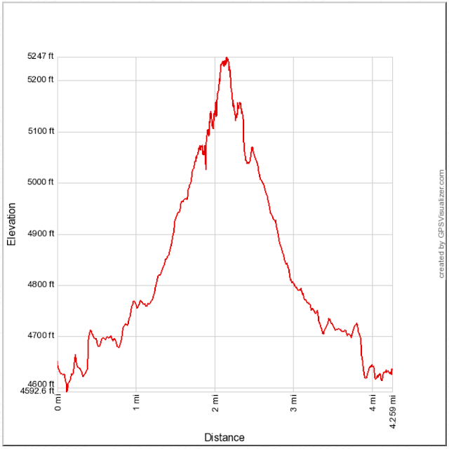
Distance: 4.2 miles round trip on trail and cross country
Summit Elevation: 5250'
Elevation Gain: 768'
Elevation Gain (in Empire State Buildings): 0.61
Round trip time: 2 hours
Recommended water: 48 oz.
Parking/Fees: Free on Highway 79 at Trout Pond parking lot
Difficulty: Moderate (route finding, summit block)
I did a 4-peak tour of the Cuyamaca area in 2016 and climbed Stonewall, but didn't feel like adding Little Stonewall at the time. This day it was a bonus hike for me on the way home from Peak 3339. I parked at the free Trout Pond parking lot about 2 miles north of the main park entrance. I knew there were connecting trails to the Stonewall Peak trail on this side but didn't know their names. The one leaving the parking lot was the Marty Minshall trail. Less than half a mile later, I turned right on the Los Caballos trail. Another 0.4 miles got me to a wooden fence that I followed, taking a left at the next junction, then right again onto the Stonewall Peak trail. Switchbacks led up the northwest side of Stonewall to the saddle between Stonewall and Little Stonewall. I left the trail looking at what appeared to be a semi-open cross country area. The true summit of Little Stonewall was not visible from below. At the bottom of the saddle is a pretty good use trail. As you scramble higher into the boulders, the brush gets dense and the use trail harder to follow. Much of the higher brush is buckthorn. There were helpful cairns along the way, but I had to back out of the brush a few times before finding my way to the summit area. The summit block consists of two granite plates next to each other.
The summit ascent was not too difficult, requiring one easy stem between the plates to mount the higher of the two. There wasn't an easy way to stand on the summit, so I straddled it like a horse. In the top crack was an altoids can with a small register, placed in May, 2017. There might have been another register around the summit somewhere, but a quick search didn't turn up anything. I signed the register on top, then dropped down for a breather. The way down was not any more clear than the way up, with some trial and error. Climbing onto a low boulder, I heard a courtesy rattle from a juvenile speckled rattlensnake at the base. It slithered to the other side where I got a partial photo of it. It was perfectly colored to match the granite and I never saw it until it moved. Back on the use trail, I was about 50' from the main trail when I got more than a courtesy rattle from the bush I was walking through. This rattlesnake was giving me a stern warning and was close enough to have hit me if he wanted. I leaped as far out of the bush as I could, but my reflexes would not have saved me if he had been in a bitey mood. Two rattlesnakes within a quarter mile put me on the defensive. I wonder how many others I walked by oblivious to the danger. Little Stonewall was a great cap on the day. Although my route finding was not perfect, I had a sizable, satisying day scrambling around San Diego County.


No comments:
Post a Comment