Distance: 15.7 miles round trip on trail and cross country
Summit Elevation: 7440' (Spitler), 7160' (Palm View), 6820' (Cone)
Prominence: 1160' (Palm View)
Elevation Gain: 4520'
Elevation Gain (in Empire State Buildings): 3.6
Round trip time: 9 hours 30 minutes
Recommended water: 164 oz.
Parking/Fees: Free at Fobes Trailhead
Difficulty: Strenuous
I aimed to pick up three remaining HPS peaks in the middle of the Desert Divide. This would complete my collection of Divide peaks, except for South Peak, ironically the northernmost. I started at Fobes Trailhead, about 4 miles up rutted Fobes Ranch Road. High clearance recommended.
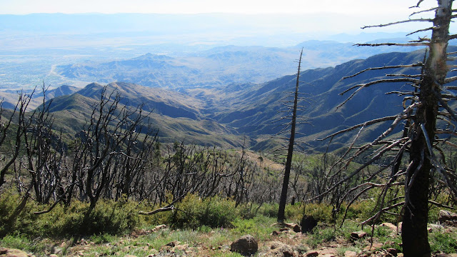
I hiked 1.5 easy miles to the PCT. On the way, Spitler looked massive with 4 sub-peaks bulging out below the high point. Cone Peak hung on a cliff and Palm View was not visible. At the PCT junction, multiple camp sites were available but empty. I turned north to tackle Spitler first. On the map, I wondered why no one went up the south ridge, but I realized the trail gained most of the elevation so why bushwhack up a steep slope. At the north ridge, I found the use trail and worked my way to the summit. Small boulders made it a walk up. There was a register but no benchmark. Spitler is higher than most of the divide and has striking views, especially north to Antsell Rock and Tahquitz. I took a more direct way down to the PCT and descended back to the intersection.
 |
| Spitler straight ahead from early on the trail |

 |
| Fobes trail junction with PCT |
 |
| Starting up the north ridge of Spitler |
 |
| Looking south toward Palm View and Cone |
 |
| Amazing view to Apache, Antsell Rock, Tahquitz, and San Jacinto |
 |
| Looking west |
 |
| Looking east |
Giant rock structures are built into the north side of Palm View. The PCT goes around them with a series of long switchbacks. I ran into 4 backpackers and one northbound thru hiker on this section of trail. Everyone kept a safe distance. I stopped for a break near the Palm View plateau. I reached the point where I needed to leave the trail for the Palm View summit, but didn't see any signs of a use trail. There was a lot of burned deadfall and small bushes, but it easy enough to pick a path through it. The Palm View summit only offered views east into the desert. Every other direction was blocked by trees. I signed the register, noting a few recent coronavirus-related signatures. I picked my way back to the PCT. Cone was next and would prove the most challenging.

 |
| Off trail for Palm View |
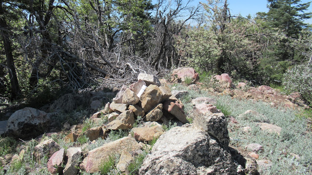 |
| Palm View summit, no views |


There was no clear use trial to Cone Peak either. I wandered down the ridge, then right around the first big outcrop. Then, I spotted a cairn. Cairns marked the path most of the way, but were spaced out enough that I often drifted too far one way or the other. The ridge to Cone has multiple major outcrops, some over 100' high and the cairns attempted to steer around them. However, some class 2 bouldering and some bushwhacking is required to make progress. Drifting away from the cairns made it more challenging. Along the way, I startled a couple of mule deer who bounded away quickly. When I got to the base of Cone, I stopped for another break. Cone Peak has two main spires, both exposed class 3. A misplaced cairn encouraged me to climb the shorter one first, and it was obvious near the top. The summit was only 100' away and I scrambled over to a flat ledge directly below it where the register was kept. Cone had great views all around. With the wind gusting, I skipped the final block. I reversed course to gain the lost elevation back to the PCT. Knowing the general path helped on the way up. Back on the PCT, it was all downhill.
 |
| Descending the ridge to Cone Peak |


Cone Peak summit


 |
| Working back up to the PCT |


Hi, tekewin, HJ here. Was Cone worthwhile? I was thinking about heading out that way for Mem Day. I missed Cone on my last couple of hikes over there for a variety of reasons, one reason being a small daughter who I didn't think could do it.
ReplyDeleteMy alternative is to go farther north and do Antsell again (2x so far). Antsell is fun and worthwhile. Not sure if I should blow off another chance at Antsell for relatively obscure Cone though. Curious if you have any thoughts on this.
Hi Jim,
DeleteI liked Cone, even though you lose some elevation getting down to it. It's not as hard as Antsell, but it has an airy class 3 summit block. I wouldn't mind visiting it again, but we'll be in Tahoe over Memorial Day.
Thanks for the 411. My partner now wants to do Kristen Peak (near Miller Peak and San Jacinto Peak). That looks like a real bun kicker. Off to do more research...
Delete