Hiked: 7/7/2016
Distance: 17.7 miles round trip on trail
Summit Elevation: 8840'
Prominence: 1360'
Elevation Gain: 5100'
Elevation Gain (in Empire State Buildings): 4.08
Round trip time: 10 hours 30 minutes
Recommended water: 150 oz.
Parking/Fees: $30 National parks fee (7 day pass for one car), $4.50 for lottery application plus $8 per permit
Difficulty: Strenuous
Encyclopedias haven been written about Half Dome. There are books and web sites dedicated to it. It is ranked #236 on the Sierra Peaks List. I'll stick to our experience, adding color to anything that was unexpected. Half Dome is so popular, the National Park Service started a lottery system in 2012 to limit the number of hikers. When I won a lottery spot for the cables route, I talked Leisa into doing this with me. We did a few training hikes in the months leading up to it and felt ready. We spent the night before at the Tenaya Lodge just outside the southern entrance to Yosemite, about an hour from Yosemite Valley. We got up early to grab a parking spot at the Happy Isles trailhead, hitting the trail around 4:15 AM. This paid off later after we saw the trail and cables fill up with teeming hordes of people.
We decided to take the Mist Trail both ways. The weather forecast was perfect sunshine for several days leading up to and including our hike date. Counting the lottery win, that's two lucky dice rolls. The 317' Vernal Fall misted us in the dark. I took a lot of photos with the flash off but they all turned out to be garbage. I got a good shot of Vernal Fall on the way down. That photo is out of chronological order. The sun was just coming up when we reached the monstrous 594' Nevada Fall. The amount of water and the force flowing over that fall was humbling. At the junction with John Muir Trail above Nevada Fall, we found an unexpected restroom facility. I marked every restroom along the trail on my GPS track, my one contribution to Half Dome knowledge.

Half Dome and the two falls from Glacier Point, taken the day before

Tunnel to Yosemite Valley

Trail sign with distances

Mist Trail sign

Vernal Fall, source of the mist on the Mist Trail (shot on the way back)

Silver apron on the Merced River

Liberty Cap

Nevada Fall
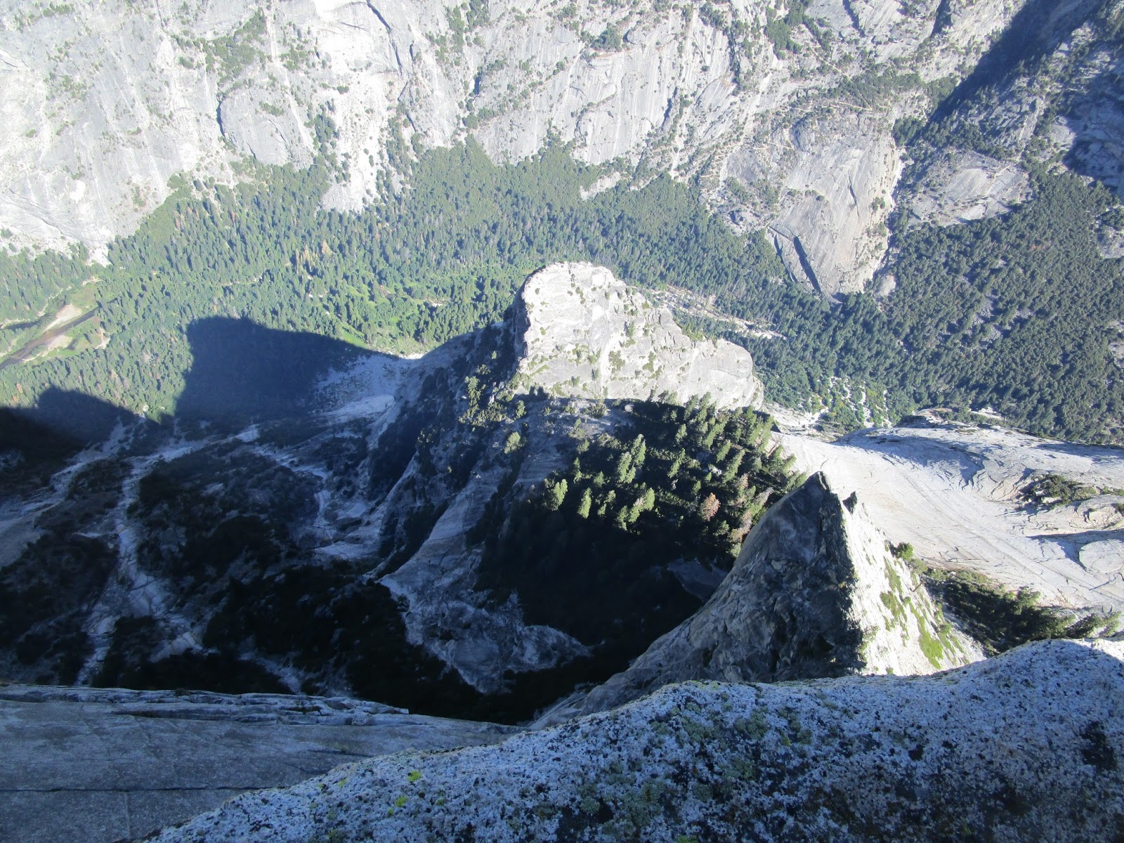
The next major section of the trail was gentle forest leading through Little Yosemite Valley. The trail went past Half Dome and offered good views of the south face. If you looked carefully, you could see the cables route above Sub Dome. We stopped at a restroom at the camp site in Little Yosemite Valley. Leisa headed down to the Merced River and refilled her water with a filter. In the cool air, I was using less water than expected and didn't need to refill the entire trip. We spotted several deer going up and coming down, but were only able to get a good photo of one buck. Climbing out of the valley, the trail gained elevation faster leading to the base of Sub Dome. To our surprise there was no ranger there checking permits. We began the slog up the variant stairs of Sub Dome. It was relatively steep and a fall there would probably lead to a bad outcome. Near the top of Sub Dome, the stairs faded away and we continued up class 1 slabs past a line of small cairns. We topped out on Sub Dome, then descended a short distance to the saddle where the cables start. Again, we were surprised to find no ranger checking permits. Other climbers were also confused about the lack of enforcement.

South face of Half Dome, Sub Dome on the right

Towering forest

Buck in Little Yosemite Valley

Approaching Sub Dome

Looking off the side of Sub Dome

Climbing the slabby upper section of Sub Dome

Looking up the cables, we beat the crowd here
I stopped to fit my camera with a shoulder strap so I could more easily take photos on the cables. We put on our rubber coated gloves to give us the best grip on the steel cables and they worked great. Leisa started up and I stayed a few feet behind her. We planned an early start to avoid crowds on the cables and our plan paid dividends. There was only one other couple on the cables when we started. We mainly used the right cable going up, hand over hand. The cables were about what I expected, although there were a few slick spots, some from wear and some from rust near the massive bolts holding the cables in place. There was not much traction with hiking boots, so it required more of an upper body effort, which was not an issue. But, rock shoes would have made the ascent more comfortable. It isn't completely smooth up the cables. The layered slabs sometimes required steps. Just past half way, Leisa started getting jittery about how steep the granite was at that point. I and the couple in front of us assured her that the slope eased up after another handful of slats. She hardened and crushed the rest of the cables. We relaxed on top, taking photos and admiring the world class views of the valley and surrounding multi-thousand foot towers of rock. After 30 minutes, we started the descent. We essentially rappelled down the left cable, much quicker than the ascent. We were somewhat relieved to get back to the Sub Dome. Someone had left their pack on Sub Dome and a squirrel was partly inside the pack, only his tail sticking out, happily munching whatever treats were inside. Not a good call. At the bottom of Sub Dome, a ranger had appeared and was checking permits. He was checking not only people on the way up, but people on the way down, including us. I presented him my papers and he sent us on our way. I think the fine for hiking without a permit is up to $5000. As we descended back to Little Yosemite Valley, the hiker traffic on the trail, especially below Vernal Fall, increased dramatically. When we looked up, we could see the crowded cables and were glad we were on the way back. Mile for mile, the Mist Trail to Half Dome may have the best scenery of any trail I've hiked. It was a big, fun day for us.

Looking down the cables

Leisa climbing to the next slat

Sideview from the cables looking east

Leisa and I on the visor

Looking up Yosemite Valley, Clouds Rest the high point on the right
View down the north face of Half Dome

Leisa celebrating victory

The long, wide summit of Half Dome

Speechless

Starting the cable descent

Squirrel in a pack left on Sub Dome, eating someone's lunch
Additional Info:
Half Dome permits (nps.gov)
Half Dome Guide (yosemitehikes.com)
Half Dome Day Hike (nps.gov)

Not sure what the glitch is at mile 16, ignored in calculating gain

The last water is a small stream by a fallen tree
Would you like to know more...?
Cool report! So someone left the backpack open, or did the squirrel figure out the zipper?
ReplyDeleteSean,
DeleteNot sure if the pack was left open, but there are rumors the squirrels will gnaw through an unattended pack. When we first saw him, he had already found the way in. He came up for air a couple of times but was back in the pack when we left.
It was slightly open because poles were sticking out of the pack, and he weaseled his way into the opening.
ReplyDeleteGreat trip and photos. 17.7 is a pretty good day.
ReplyDeleteThat was car to car. You get about an extra mile round trip from the parking lot. We also diverted to the campground in Little Yosemite Valley both ways for the restroom.
DeleteWow. You guys had a nice quiet day. Awesome.
ReplyDeleteCool Shirt,
DeleteIt was quiet at first, only a few other hikers on the trail. On the way back, it got busier and below Vernal Fall was a crowded mass of people.