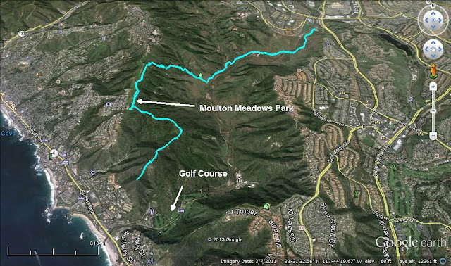
Hiked: 7/7/2013
Distance: 10 miles round trip on trail
Summit Elevation: 888' (high point on the ridge)
Elevation Gain: 1250'
Elevation Gain (in Empire State Buildings): 1.00
Round trip time: 3 hours
Recommended water: 64 oz.
Parking/Fees: $3 OC Parks
Difficulty: Moderate
Like all hikes that start at the Aliso-Wood Canyon parking lot, there is a tedious 1.5 mile segment along the road to get to Wood Canyon and the other trails. On the plus side, there is a surprising amount of wild life in the canyon and sometimes you spot a bobcat or rattlesnake along the way. For directions and maps, check out the OC Parks web site. For a good description of the first 1.5 miles, check my post on Aliso-Wood Canyon to the Top of the World.
From the parking lot, follow the road or trail parallel to the road until you reach the main trail into Wood Canyon. Almost immediately after turning right into Wood Canyon, the signed Meadows Trail branches off to the left and wanders parallel to the road until you cross a wooden foot bridge and hit a T-junction at a dirt road. At the junction, turn right and continue on the Meadows Trail up the ridge. This is where most of the elevation gain and work is. Watch out for mountain bikers coming down.
The Meadows Trail ends at the top of the ridge where it intersects Sommet Du Monde Road. I turned left on a use trail before the road and followed it past a fenced goat farm with about 50 curious goats. The City of Laguna Beach uses these "fire goats" to clear dried grass and brush from the hills to reduce the threat of fires. I continued southwest about half a mile to Moulton Meadows Park, staying on the left side of the park as I approached. The park has water fountains and picnic tables, but I didn't see any restrooms. Near the south end of the park, there is a playground. Before that, there is an exercise sign that reads "Achilles Stretch". Just past the sign is a pine tree and a use trail veering left. Leave the park and take the use trail to continue along the ridge of Aliso Canyon. I did not find the trail immediately. I ducked into and out of the brush a few times, as a lady with two dogs sitting at one of the picnic tables watched with suspicion. She might have thought I was a shady burglar casing the neighborhood, cleverly disguised as a hiker.
The trail turns into a fire break, then eventually back into a single track trail as the ridge line descends a few hundred feet. I followed the ridge to a small unnamed hill directly overlooking the well hidden Aliso Creek Inn 9-hole golf course tucked into the canyon, Laguna Beach and the Pacific Ocean. From the hill, I could see the packed parking lot for Aliso Creek Beach and a mass of humanity enjoying the 4th of July weekend. The hill had what looked like an Orange County Surveyor benchmark sticking out of the ground, but it was missing the cap. I rested a bit, ate my snacks, and pondered whether this trek into the Canyon would allow me to list my house as "within walking distance of the beach". While returning along the same path, I spotted a large road runner on the trail, who was always a few seconds ahead of my camera. As I was returning through the Moulton Meadows Park, I saw an orangey bobcat on the edge of the brush, but once again, he was faster than my camera and slipped silently into the brush.


Not usually a fact checker, but I did notice this: "At the top of the switchbacks is Trail Crest at 13600'. It allows spectacular views both east and west of the Whitney ridge. Many of the large Sierra lakes come into view from here. The trail continues north along the east side of the ridge behind Muir Peak, the needles, and finally Mt. Whitney."
ReplyDeleteThe trail is actually on the West side of Muir, as the East side is a vertical wall that overlooks Trail Camp. Did you consider spending the night before your hike at Horseshoe Meadow instead of down in town? Any time spent at 10,000 feet is helpful for the ascent of Whitney, and there is a quite nice campground there you can drive to.
Hillbasher,
DeleteI think you meant this comment for the Whitney hike. I appreciate the tip and fixed the report. We thought about spending the night up there and we did do a training hike from Horseshoe Meadows to Chicken Spring Lake. It certainly would have made the trip easier had we acclimated properly.