Monday, April 18, 2016

Iron Mountain #3, Monte Cristo, Round Top, Granite, Rabbit

Hiked: 4/17/2016
Distance: 10.5 miles round trip on dirt road, firebreak, and use trail
Summit Elevation: 4275' (Monte Cristo), 5040' (Iron #3), 6316' (Round Top), 6600' (Granite), 5307' (Rabbit)
Prominence: 320' (Iron #3), 400' (Granite)
Elevation Gain: 4175'
Elevation Gain (in Empire State Buildings): 3.34
Round trip time: 6 hours 30 minutes
Recommended water: 128 oz.
Parking/Fees: Adventure Pass
Difficulty: Strenuous (combined)

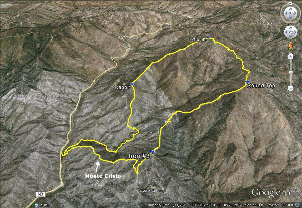
Madison and I had been talking about this one for months and we finally worked out our schedules to make it happen. I was stoked to climb the third and final Iron Mountain in the San Gabriels. Alone, it was the easiest of the three, but the loop over 5 peaks was a substantial piece of work. Here is Madison's report. We got started around 7 AM with near perfect weather. This was our itinerary:

1. Monte Cristo (unofficial)
2. Iron Mountain #3 (HPS)
3. Round Top (HPS)
4. Granite (HPS)
5. Rabbit (HPS)

The loop can be done in either direction. We parked just off the road above Monte Cristo Campground and went down to the dirt road on the left. Campers in hammocks were motionless and asleep as we started up a drainage just before the gate. It wasn't a trail, but it allowed us to get on the ridge to Monte Cristo. We found a use trail on the ridge and followed it up. We didn't find anything at the high point on Monte Cristo, so we continued on toward Iron #3. The ridge intersected a dirt road below Iron. We turned right and caught the next ridge at a bend. We made quick work of Iron #3 and appreciated the views of the back side of the entire front range. In particular, the north face of Strawberry Peak was impressive. No benchmark was found on Iron but there was a register. Unfortunately, it was soaked and unreadable. Completely ruined.


Monte Cristo campground


We went up the drainage on the right, came back along the road


Looking down on the campground, the shadow of Iron #3 on the left


Heading up Monte Cristo, Round Top distant left


Strawberry Peak and Josephine Peak from Monte Cristo


On the Iron #3 ridge


The ruined Iron #3 register

The next peak in the loop was Round Top at 6316'. You drop about 300' a saddle, then begin the 1600' climb, going over three false summits along the way. This is the crux of the loop in this direction. There was a surprisingly good use trail up the steepest part. When we reached the top, a sustained 30-40 mph wind blasted us. It nearly blew my hat away, eventually forcing me to reverse it. There was a triangle post just below the summit and a small cairn. No benchmark or register. We took a break on Round Top to refuel and rest up for the next leg to Granite, the highest point in the loop. We followed the road down from Round Top and more than half way up Granite before we left it to find the summit. Granite had a large summit area with various boulder formations and burnt trees. We wandered around a bit before finding the highest point, a 10' boulder with the register underneath. The wind was relentless, turning a pleasantly cool morning into a cold one. We took shelter on the opposite side of some boulders to finish our lunch. The Granite register was also very wet and we were unable to sign it. Our subsequent hunt for a Granite Mountain benchmark came up empty. We packed up and started down the long Granite ridge toward Rabbit.


Round Top (right) and Granite Mountain (left) from Iron #3


Madison starting the climb up to Round Top, Iron #3 in the background


After several false summits, the final approach to Round Top


Leaving Round Top on the way to Granite


Looking north from the Granite summit


On the smallish Granite summit boulder


Burned forest on top of Granite

When we got below Granite, we got a break from the wind. There were interesting rock formations along the way and an abundance of yucca. After a long descent, we hit the saddle below Rabbit and began our last climb, a couple of hundred feet to the Rabbit summit. There was large cairn there, no benchmark, and a dry register. We were able to sign in for the first time. Dropping down from Rabbit, we met three other hikers who were starting the loop in the opposite direction. Doing the loop that way gets all of the gain over at once, but seems somewhat more difficult. We had a short visit and went our separate ways. Soon enough, we hit a dirt road cutting across Rabbit. After a brief discussion, we decided to take a shortcut down a ridge below electrical towers. It probably saved us a half mile or so. We didn't consider going further down the ridge, but it proved a better shortcut when we saw where it met the road. It was an easy stroll back to the campground and we were satisfied with the multiple summits of the day.


Descending from Granite


Approaching Rabbit
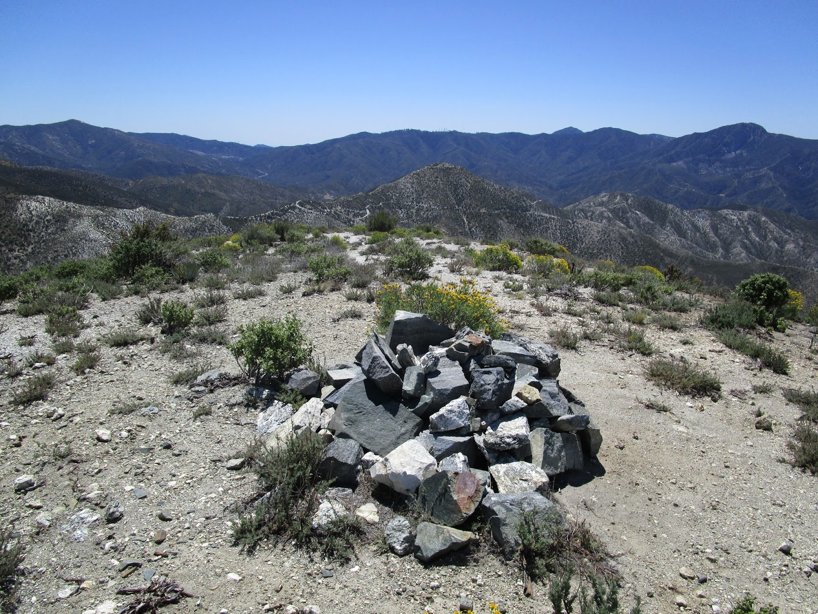

Rabbit summit, Iron #3 in the background


We found two of these strange white marks, one on each side of Rabbit.
They were in areas too small for helicopters.


Shortcut below Rabbit


Monday, April 11, 2016

Horsethief Peak via East Horsethief Trail

Hiked: 4/10/2016
Distance: 9.7 miles round trip on trail
Summit Elevation: 4313'
Elevation Gain: 2850'
Elevation Gain (in Empire State Buildings): 2.28
Round trip time: 4 hours
Recommended water: 64 oz.
Parking/Fees: Free on Rice Canyon Road
Difficulty: Moderate

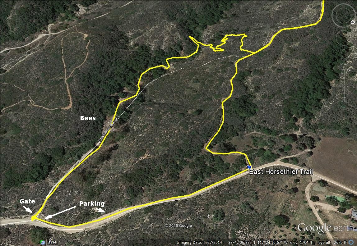
This was a last minute hike to explore the East Horsethief Trail from Lake Elsinore. Most of the semi-recent beta in the last five years came from mountain bikers, with mixed reviews from a few hiking sites. To get to the trail from Orange County, take highway 74 over the Santa Ana Mountains into Lake Elsinore and follow it as it turns north. Turn left on Grand Avenue, then left again on Mountain Street. At the end of Mountain Steet, there is a dirt road that forks three directions. Take the middle road, Rice Canyon. You soon reach a gate on the left that Google Maps thinks is the trail, but it's not. The USGS shows the trail starting about a quarter mile further up the road on the left. Trust the USGS on this one. You can park at the first gate or at a wide section of the road around a bend and walk up the road a short distance to the trail. There was no space for parking at the trailhead.

Not knowing any better, I parked at the gate and went through it to follow the dirt road. I immediately found myself in the middle of a hundred commercial bee hives from the Happie Bee Co., Menifee, CA. Bees were flying back and forth between the hives that lined both sides of the road. I covered my head and walked briskly, without running, to the other side. A few bees flew into me unintentionally without bothering to sting me. I followed use trails past some camp sites down into the creek looking for a connector trail to East Horsethief. Maybe there was a connector trail somewhere but I didn't find it, instead suffering a short thrash up the creek until I hit the main trail.


End of Mountain Street, start of Rice Canyon dirt road


Gate at wrong trailhead, leads to bees and brush


East Horsethief Trailhead, parking available further back along the road


Bees


Trying to find the trail


Back on the East Horsethief Trail

It had been raining the last few days and more rain was forecast today. The trail was sloppy in places. I saw mountain bike tracks but no human footprints. This explained the rutted nature of big parts of the trail. With or without clouds, the views of Lake Elsinore, Horsethief Canyon, and Rice Canyon were great. The trail climbed in manageable chunks with level spots along the ridge to catch your breath. It was in much better shape than I expected and easy to follow. Only a few spots could have used some trimming. I went through a stand of pines just before reaching Main Divide Road. From there, continue straight up the brushy north firebreak to Horsethief Peak or turn left and head to the clear south firebreak. I had already battled the north on a previous trip so I went down the road to the clear firebreak. Clouds drifted over the summit just as I arrived and conspired with the brush to limit the view. Horsethief hasn't been crowned with a benchmark or register so far. I only stayed on top long enough to add tape to my heels and hydrate. Then, I started the much faster trip down. Dark clouds threatened the descent, but I only got some light rain. It was raining harder farther away over Lake Elsinore.


Lake Elsinore


Trabucco Peak


Rutted


Cloud shadows over the Gavilan Plateau and surrounding peaks


Deep wash next to East Horsethief Trail


Pine stand before Main Divide Road


Intersection with Main Divide


Firebreak to Horsethief


Horsethief summit


Dark clouds and rain


Monday, April 4, 2016

Wolverton Mountain, AZ

Hiked: 4/2/2016
Distance: 4.1 miles round trip on trail and use trail
Summit Elevation: 6704'
Elevation Gain: 500'
Elevation Gain (in Empire State Buildings): 0.4
Round trip time: 2 hours
Recommended water: 24 oz.
Parking/Fees: Free at Aspen Creek Trailhead
Difficulty: Easy

We were in Prescott, AZ for a final tour of Embry-Riddle Aeronautical University, one of the two finalists my daughter was considering for college. We didn't want to drag Parker around campus all day so instead, I dragged him up Wolverton Mountain. Wolverton was really a consolation prize. I wanted to climb Thumb Butte, a short and popular hike near town, but the summit is closed from January to July for peregrine falcon nesting season. A search for another local mountain led to Wolverton, though there was little beta on it outside a few mountain biking blogs. The Wolverton Mountain trail runs below it and can be accessed from highway 89 or the Aspen Creek Trailhead from Copper Basin Road. Copper Basin Road turned to dirt a few miles before the trail, but it was well graded and did not require high clearance.

From the trailhead, cross the road to find trail #48. The trail leading out of the parking lot does not go to Wolverton. It starts along Aspen Creek, which was flowing a little, then crosses over and starts heading up a long switchback. The trail is smooth and surrounded by tall pines that scented the air. At the first junction, stay on trail #48 to the right. The second junction is signed and the Wolverton Trail, #9415, heads left. In another mile, you reach the base of Wolverton. A dirt road branches left here while the trail continues around the mountain to the right. At this intersection, just off the road, we found what looked like a small pet cemetery. A wooden grave marker with the name Trixi was starting to decay and a larger marker on another spot nearby had already fallen.


Start of trail #48


Rock outcrop


Woodpeckers were very active


Wolverton Mountain Trail junction


R.I.P. Trixi

We continued down the road, then took the first use trail we found to what turned out to be the first of two false summits. We descended back to the road and followed it to the just below the true summit. Then, we did some light bushwhacking until we found the top with a wooden bench. The views of the local area were great in most directions, including Thumb Butte and snowy Mount Humphreys, the Arizona high point about 80 miles away. Views behind the bench were blocked by trees. After a short rest, we discovered a nice use trail leading down and followed it to see if it went back to the road. Indeed, it led right back to where we left the road. There was a lone cairn there near the road, but the use trail was somewhat hidden. I set up a second cairn closer to the use trail. It was a fun diversion with near perfect weather.


Parker on the summit bench, not enthusiastic about being photographed


Thumb Butte and Granite Mountain from Wolverton


Prescott and Mt. Humphreys in the distance


Close up of 12633' Mt. Humphreys about 80 miles away