Distance: 9.7 miles round trip on trail
Summit Elevation: 4313'
Elevation Gain: 2850'
Elevation Gain (in Empire State Buildings): 2.28
Round trip time: 4 hours
Recommended water: 64 oz.
Parking/Fees: Free on Rice Canyon Road
Difficulty: Moderate
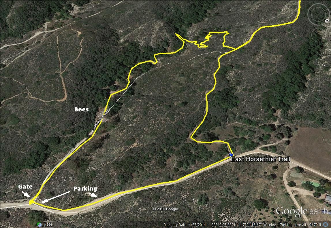
This was a last minute hike to explore the East Horsethief Trail from Lake Elsinore. Most of the semi-recent beta in the last five years came from mountain bikers, with mixed reviews from a few hiking sites. To get to the trail from Orange County, take highway 74 over the Santa Ana Mountains into Lake Elsinore and follow it as it turns north. Turn left on Grand Avenue, then left again on Mountain Street. At the end of Mountain Steet, there is a dirt road that forks three directions. Take the middle road, Rice Canyon. You soon reach a gate on the left that Google Maps thinks is the trail, but it's not. The USGS shows the trail starting about a quarter mile further up the road on the left. Trust the USGS on this one. You can park at the first gate or at a wide section of the road around a bend and walk up the road a short distance to the trail. There was no space for parking at the trailhead.
Not knowing any better, I parked at the gate and went through it to follow the dirt road. I immediately found myself in the middle of a hundred commercial bee hives from the Happie Bee Co., Menifee, CA. Bees were flying back and forth between the hives that lined both sides of the road. I covered my head and walked briskly, without running, to the other side. A few bees flew into me unintentionally without bothering to sting me. I followed use trails past some camp sites down into the creek looking for a connector trail to East Horsethief. Maybe there was a connector trail somewhere but I didn't find it, instead suffering a short thrash up the creek until I hit the main trail.

End of Mountain Street, start of Rice Canyon dirt road

Gate at wrong trailhead, leads to bees and brush

East Horsethief Trailhead, parking available further back along the road

Bees

Trying to find the trail

Back on the East Horsethief Trail
It had been raining the last few days and more rain was forecast today. The trail was sloppy in places. I saw mountain bike tracks but no human footprints. This explained the rutted nature of big parts of the trail. With or without clouds, the views of Lake Elsinore, Horsethief Canyon, and Rice Canyon were great. The trail climbed in manageable chunks with level spots along the ridge to catch your breath. It was in much better shape than I expected and easy to follow. Only a few spots could have used some trimming. I went through a stand of pines just before reaching Main Divide Road. From there, continue straight up the brushy north firebreak to Horsethief Peak or turn left and head to the clear south firebreak. I had already battled the north on a previous trip so I went down the road to the clear firebreak. Clouds drifted over the summit just as I arrived and conspired with the brush to limit the view. Horsethief hasn't been crowned with a benchmark or register so far. I only stayed on top long enough to add tape to my heels and hydrate. Then, I started the much faster trip down. Dark clouds threatened the descent, but I only got some light rain. It was raining harder farther away over Lake Elsinore.

Lake Elsinore

Trabucco Peak

Rutted

Cloud shadows over the Gavilan Plateau and surrounding peaks

Deep wash next to East Horsethief Trail

Pine stand before Main Divide Road

Intersection with Main Divide

Firebreak to Horsethief

Horsethief summit

Dark clouds and rain


Hey,
ReplyDeleteThanks for posting pictures. I just moved to the area and did this hike yesterday. I walked passed the trailhead quite a days and only found it after looking at the pictures you posted.
It's definitely a tough one. Did about 2 miles before turning around because it was late in the day. I'm planning for the full trail later this week.
Unknown,
DeleteGreat! It is a little known trail. If you want to summit Horsethief Peak, take a left at Main Divide, then right on the fire break. Going straight up from the road leads to thick brush.
I made it to the top today. It was definitely one of the more challenging hikes and I wasn't quite prepared for the extreme elevation changes. I made it to the fire road but didn't go beyond. I saw the center rut/trail but it didn't look scalable. I ended up turning back right at the main divide. It's a shame because it looks like it was just a few minutes further to thw summit. Since I now live right near the trailhead, I will definitely be doing it again soon. Thanks again for the detailed info. I never would have found it otherwise.
DeleteHiker,
DeleteYou were so close, only about a 1/4 of a mile away. You'll definitely get it next time!
hi I want to hike this trail to trabuco peak. do you know if that's possible?
ReplyDeleteJoe,
DeleteCertainly possible. Just turn right when you get to Main Divide and follow it to Trabuco.
I won't get in trouble for doing that? I thought the main divide road was closed?
DeleteHmm, looks like that section of road from Santiago to Ortega is closed right now. Often, it's just closed to vehicles, but you might be right. You could call the ranger station to check if hiking is OK.
Delete