Hiked: 4/12/2019
Distance: 12.1 miles round trip on trail and cross country
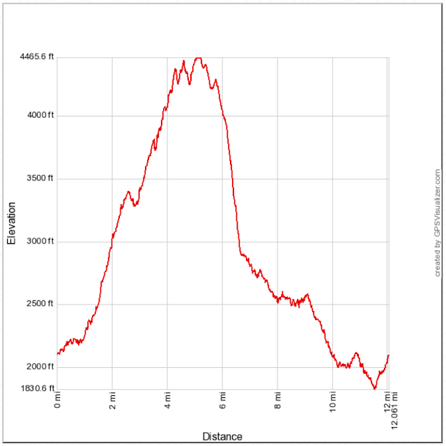
Summit Elevation: 4466' (Brown), 4406' (4406), 4288' (4288)
Elevation Gain: 4211'
Elevation Gain (in Empire State Buildings): 3.4
Round trip time: 6 hours 40 minutes
Recommended water: 92 oz.
Parking/Fees: Adventure Pass at Sunset Ridge
Difficulty: Strenuous
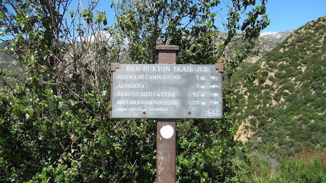
John Robinson's Trails of the Angeles was the first hiking book I ever read. I used to spend hours going through each hike in the book and dog eared the pages for hikes I wanted to do. One of those was the classic Brown Mountain Loop (Hike 21 in my edition). It starts at Sunset Ridge above Millard Campground but parking at the campground works just as well. To get there from Loma Alta Drive in Altadena, go north on Chaney Trail to the parking area on Sunset Ridge outside a locked gate. The loop goes up Sunset Ridge trail and Millard Canyon past Dawn Mine to Tom Sloan Saddle, then over Brown Mountain, down the northwest ridge firebreak (picking up peakbagger peaks 4406 and 4288) to Ken Burton Junction, circling back to the Campground on Brown Mountain Road. I completed this hike with a short side trip into Grand Canyon to pick up a trailcam.
I think this was my fifth trip up Millard and Grand Canyon on the Sunset Ridge trail. Nothing much has changed over the last year except for some downed trees and a trail crew fixing things up. There was still plenty of water in the streams and plenty water coming over Millard Falls. I continued past Dawn Mine without stopping and ducked up Grand Canyon to grab a trailcam. The camera didn't have much on it -- one bear and a few deer. When I got out of Grand Canyon, I continued up to Tom Sloan Saddle. The trail was in a good shape with only one fallen tree across it. I stopped for calories at the saddle, then continued up to Brown Mountain over several bumps. A large rock cairn was at the summit with two registers. One looked like the regular Sierra Club register and the other was for something called the Mini Six Pack of Peaks. I hadn't heard of that before but must be some kind of play on SoCal Hiker's Six Pack of Peaks. It was nice day so I relaxed at the summit a while. I could see downtown LA through the smog, also Lukens and the peaks around San Gabriel Peak.
I started down the northwest ridge with quick stops at Peak 4406 (with a metal post) and Peak 4288 (with nothing I noticed). There was a decent use trail down the firebreak, but it grew increasingly steep and was somewhat overgrown as it neared Ken Burton Junction and Brown Mountain Road. The last part of the ridge was uncomfortably steep and loose, but I was glad to be going down instead of up. When I got to the road, I met the first other human for the day, a mountain biker. I ended up meeting 4 other bikers on the way back to Millard Camp but no other hikers. From Ken Burton Junction, it's 5.5 miles back. And it's mostly uninteresting single track hugging the canyon walls. The only odd thing I noticed was a stand of tall pine trees about half way back that seemed out of place. In any case, I was glad to be on easy terrain and finished without any further breaks. There is one final 400' gain at the end on a connecting trail to the Sunset Ridge parking lot.


No comments:
Post a Comment