Hiked: 12/27/2018
Distance: 5.3 miles round trip cross country and dirt road
Summit Elevation: 2689' (Bernasconi), 2677' (Perris)
Prominence: 1029' (Bernasconi), 360' (Perris)
Elevation Gain: 1707'
Elevation Gain (in Empire State Buildings): 1.36
Round trip time: 3 hours 45 minutes
Recommended water: 80 oz.
Parking/Fees: $10 CA State Parks
Difficulty: Moderate
The mountains around Lake Perris in Moreno Valley are a boulder strewn playground. I had been to the park once before to tag Mt. Russell on the Lower Peaks List. This visit was to traverse the Bernasconi Hills, south of the lake. The Bernasconi Hills High Point is also a tasty P1K. During the winter months, the area is open to bird hunters, so it's best to wear bright clothing. I didn't see anyone or hear any gunshots the whole day. I drove into the park on Bernasconi Drive and paid $10 to the unattended automated machine for entrance to the park. About 100' past the entrance on the right, I parked in a dirt lot at the west end of the hills. I ascended directly up the west ridge, a little muddy from rain two days earlier. I passed over a false summit, then dropped to a saddle and went north toward the high point. With minimal route finding, nothing was more than class 2, including the summit boulder. There were good views from the summit, especially toward Perris Benchmark a couple of miles further along the ridge. Rock features blocked views of some parts of the lake. I did not find a benchmark or register. I had a quick snack break, then started down the ridge toward Perris.
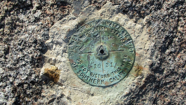
I found a good animal trail down to the the first shallow saddle. Cresting the first bump, I realized there were several bumps to navigate between the high point and Perris. The winter brush was light and brittle offering little resistance. Tall rock features dotted the ridge making the trek interesting. As I neared the end of the ridge, I climbed the highest boulder, the only class 3 of the day. From the top, I saw a marker on the next, lower boulder. That was the location of the Perris Benchmark with great views of the lake and surroundings. I didn't find a register. One more quick break, and I started down, continuing southwest to a gully that I wanted to follow to the dirt road that ran parallel to the hills. It was a very steep descent and it would be a hard way to ascend (do not recommend coming up this way). As I started back along the road, I spotted what appeared to be the remains of a large bird. Feathers radiated out from a central circle. I took a couple feathers home where Google Lens predicted they were from a wild turkey, but it was identified by Joseph Esparza as a golden pheasant. My guess is a hunter bagged one here. Shortly after that, I startled a buck that was hiding in the low brush. He dashed ahead, eventually heading up into the hills. This was a short, fun traverse on some less frequented low mountains.


Nice trip, you should have stopped by to see me at work in the museum. Kinda sad I work here, and still haven't done this trip...so little time.
ReplyDeleteThe feathers are from a Golden Pheasant, DFW releases them in the park each autumn for hunters. The lucky ones hang around and scare visitors in the Springtime
Joseph,
DeleteThanks for the ID, I've updated the report. I would have stopped by if I knew you were working. Interesting gig. I almost went over to do Terri Peak, but didn't, so now I have another excuse to go back. The mountains around the lake are fun.
Nice one Tekewin--looks like a fun, sculptured rock playground--& creatively off the beaten tracks. Image 4 seemingly emanates Native American "power spot" energy. Per usual, your photos are superb. Do you carry a camera rig or shoot via phone?
ReplyDeleteGloop,
DeleteThat small natural cave caught my attention. Most photos are from a cheap Canon Powershot Elph 190, the smallest point and shoot I could find. Sometimes I'll take a shot from my phone (Galaxy S9) which produces better results. I usually prefer to leave my phone safely packed away. I love seeing pro shots from DSLRs but I don't have the money and don't want to carry something that heavy.