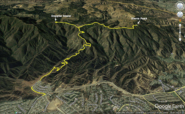
Hiked: 1/14/2018
Distance: 17.1 miles round trip on dirt road
Summit Elevation: 3045'
Elevation Gain: 3196'
Elevation Gain (in Empire State Buildings): 2.55
Round trip time: 6 hours 15 minutes
Recommended water: 88 oz.
Parking/Fees: Free on Foothill Parkway
Difficulty: Strenuous
This day didn't go as planned. I was going to drive up to Santiago Peak and do some exploring around the summit, but the gate on Maple Springs Road was closed. My backup plan was to check out the Doppler radar tower above Beek's Place by going up Skyline Drive in Corona. Because of the late start, I had to park a long way from the trail on Foothill Parkway. Skyline rose at a low grade and had dozens of switchbacks. This was great on the way up, but tedious on the way down. The trail was busy with a 50/50 mix of hikers and mountain bikers. I cruised up at a reasonable pace to the intersection of Skyline and Main Divide Road. At the intersection were four large thin red and white radio towers I had never noticed before. I took a left on Main Divide and went by Beek's Place to the Doppler tower. The tower pieces were assembled in a way that made it look like a cracked egg. While I was there, I wanted to check out the ridge line down into Tin Mine Canyon. I poked around and wandered a short distance down what looked like an animal trail. The trail was quickly swallowed by brush and it confirmed my suspicion that any descent along that ridge was going to be problematic. Not only was it dense, there are sub-ridges, and staying on track would be difficult. In any case, I was unprepared for a serious brush fight. As I started back, I noticed Sierra Peak in the distance. It didn't look too far and the GPS calculated it at 2 miles as the crow flies. I was short on water but decided I could make it. I wanted to check out the burn damage around the peak from the Canyon Fire that scorched 2600 acres back in September. The road took many twists turning the 2 crow miles into 3 biped miles.
When I got close, I could see the entire summit area had been barbecued. Every plant on the eastern slopes was black and there was no grass. The southeast tower apparently took the brunt of the fire as it swept over the summit. It was destroyed. A sign on the tower warned that it was unsafe. The northwest tower had some burns on the building, but appeared to be operating. Remarkably, the rest of the towers looked fine, some with superficial smoke damage. The benchmark was still in place. It was another clear day with fantastic views, including a crisp outline of Catalina. I rested below the destroyed tower for a while and nursed the water I had left. It was a long way back but the road was easy going. There were several mountain bike use trails that could be taken as shortcuts down Skyline Drive. I only took one shortcut, dodging a red bike bombing down at 40mph. I wished I had taken more since the lower switchbacks were interminable. A 17 mile hike usually leaves me soaked in sweat, but minor dehydration left me dry. I picked up some extra water while driving home.


Would you recommend Sierra Peak by this route or from Green River along the 91? It looks like this is a better route, and might get you away from the noise.
ReplyDeleteAnd, what about Pleasants Peak? This route, or from OC?
Mike,
DeleteSkyline has a mild grade but it is longer. I did a loop from Green River, but if you did an out and back up the Pipeline trail, it would be even shorter. You would definitely have more company and mountain bikers on Skyline if that is a factor. Views were better on Skyline.
Never mind about Pleasants - looks like the trail out of Silverado Cyn is the way to go for that (which could include Bedford on the same trip)
ReplyDeleteDid Sierra Peak from Skyline yesterday. You are right, nice views. There was haze to the west (marine layer). Saw no one from mile 3 to mile 11. Had the summit to myself.
ReplyDeleteSoCalMike,
DeleteNot too surprised you were alone on the summit, I don't think many people make the trip. It's in a pretty strategic location and I always notice it when I'm driving west on the 91.
You probably figured out it was me (I logged into the wrong Google account), but I forgot to tell you - have you seen this book, or have a copy of it? If you don't, get a copy - maybe Santa will bring you a copy: https://www.amazon.com/Coast-Cactus-Canyoneer-Trail-Outdoors/dp/194138420X/ref=sr_1_1?s=books&ie=UTF8&qid=1543026958&sr=1-1&keywords=coast+to+cactus
ReplyDeleteHope you had a nice Thanksgiving, Keith.
Mike,
DeleteI didn't know it was you. I haven't seen that book, but I like the idea of compiled reports from multiple authors. Will definitely check it out. Thanks.