Distance: 14.5 miles round trip on trail and cross country
Summit Elevation: 1538' (at trailhead)
Elevation Gain: 2340'
Elevation Gain (in Empire State Buildings): 1.87
Round trip time: 7 hours
Recommended water: 104 oz.
Parking/Fees: Adventure Pass
Difficulty: Strenuous (combined)
I spent a respectable amount of time this year exploring the San Mateo Wilderness. One feature that caught my imagination was Bluewater Canyon, a gorge near the center of the wilderness. The Bluewater trail enters the canyon for less than a mile, then switchbacks up toward Oak Flats. I wanted to explore the wild places in the canyon.
I parked at the Fisherman's Camp TH on Tenaja Truck Trail and displayed my Adventure Pass. To get there from I-15, exit on Clinton Keith Road, go west/southwest until it turns into Tenaja Road. In less than 2 miles, you will come to a stop sign where you need to turn right to stay on Tenaja Road. Go another 4 miles, then turn right on Cleveland Forest Road (7S01). Go past the Tenaja Trailhead for 3 more miles to the Fisherman's Camp Trailhead at a turn out on the left. The small turn out only has enough parking for 3-4 cars. The trail leads to Fisherman's Camp only 1.6 miles away at the confluence of Tenaja Canyon and San Mateo Canyon. Three trails converge on Fisherman's Camp. The first one you hit before reaching the camp. That trail leads to the Tenaja Falls trailhead. Two trails converge on the other side of the camp. One leads to the Tenaja trailhead and the other leads to San Mateo Canyon and Bluewater Canyon. One of the undeveloped camp sites at Fisherman's Camp was occupied. I greeted the two guys having breakfast by their tent and passed through to the connecting trail toward Bluewater Canyon.
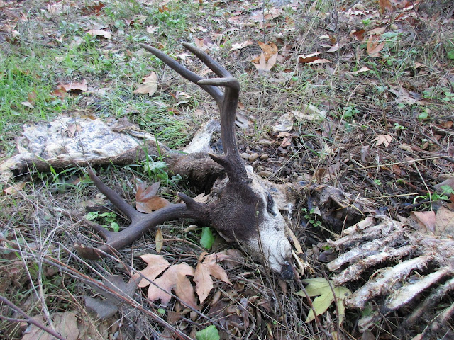
I passed the North Tenaja junction, continuing to the Bluewater Trail, then entered Bluewater Canyon. I crossed a flowing stream four or five times on the way in. The gurgling water made it seem different than the first time I was there. I quickly reached the start of switchbacks where I abandoned the trail. At first, the canyon was pretty clear. If I could not easily stay in the stream, I picked whatever bank looked the least dense and advanced slowly, switching sides as needed. I was surprised to find a pretty good use trail on the east bank, but it didn't last long. Less than half a mile from the trail, I stumbled on a deer head, an 8 point buck separated from its body but still attached to a single, long flap of fur. The eyes were still intact, but it was not a fresh kill. Part of the spine and rib cage lay next to the head. Two partial legs were about 10' away, gnawed to the bone above the ankle. About 20' away was a hip bone and the lower part of the spine. Two faint animal trails led to the feeding area, one from a side canyon and one upstream. Given the remoteness and confinement of the area, it was a little unsettling. After some photos and video, I headed upstream. The bushwhacking was only moderate. Chest high soft brush and grass mixed with dead trees. I don't remember seeing much poison oak, but maybe the vines were bare. Not far past the killing field, I found what looked like a lion day bed, about 8'x8'. And not far past that, another potential day bed. I felt like I was stomping through brush, kicking the front doors in on every house on lion street. I didn't like the tactical situation. There was only one way in and one way out. I decided this canyon was not a solo project. In the sequel, I'll return with the colonial marines.
After retreating from Bluewater Canyon, I had some time left. Since I had not been down San Mateo Canyon, I decided to follow that trail a few miles. It was in good shape and easy to follow. Cairns marked the places to cross to the other side. Water was flowing strongly after several days of rain. Sections of the trail climbed up above the canyon, then dropped back to the bottom. San Mateo Canyon had large boulders, some larger than cars. The flowing water was broken up periodically by serene pools. I stopped at one of the scenic overlooks for a break. The trail gradually got overgrown with high grass and became more difficult to follow. I stopped at a somewhat tricky crossing, a little short of the Clark trail junction. On the way back, I climbed the largest boulder I had seen on the way out. Between the Bluewater junction and Fisherman's Camp, I saw another group of campers on the south side of San Mateo Canyon. Arguably, this area is gaining in popularity.
See also:
Bluewater Canyon Reloaded


Some of those shots of San Mateo Canyon look a lot like the Sespe.
ReplyDeleteGood call on turning back in lion country. I would have been a tad nervous too.
Madison,
DeleteYes, I see a Sespe resemblance now that you mention it. I have a hypothesis that Santa Ana lions live mostly in the wild canyons. It is the only source of water and the canyons see little human traffic compared to the ridges and peaks. Perfect for ripping flesh from prey in peace.
Nice write up. I'm thinking about heading out there on the first with my sidekick. Hope NOT to have any lion encounters. Ulp.
ReplyDeleteHJ
HJ,
DeleteI'm pretty sure the cougars in Bluewater Canyon have moved on or passed on. Of course, there could be others. As Newt said in Aliens, "They mostly come at night, mostly". Have fun!