Distance: 6.7 miles round trip on trail and cross country
Summit Elevation: 3103'
Prominence: 433'
Elevation Gain: 2150'
Elevation Gain (in Empire State Buildings): 1.72
Round trip time: 4 hours
Recommended water: 92 oz.
Parking/Fees: Free on Sarda Ct.
Difficulty: Moderate
Rod and I turned our sights south to Mt. Gower on the San Diego Peak list. Mt. Gower is a few miles outside Ramona, CA. We arrived at the cul-de-sac on Sarda Ct. around 9:30 AM and proceeded up the access road toward the water tower. The trail continues along the ridge behind the tower with some roller coaster action, eventually turning right up to Gower's west summit. We approached an interesting group of rocks we decided to call Gower's Teeth. We paused to climb some teeth, then turned left up a use trail at that spot.

Heading up the access road toward the water tower

West summit of Mt. Gower in the early going

Rod with the drone on his chest, I would prefer a chest mounted laser canon

Gower's Teeth

Rod on a tooth

Up the tooth

West summit

Looking back from near the west summit
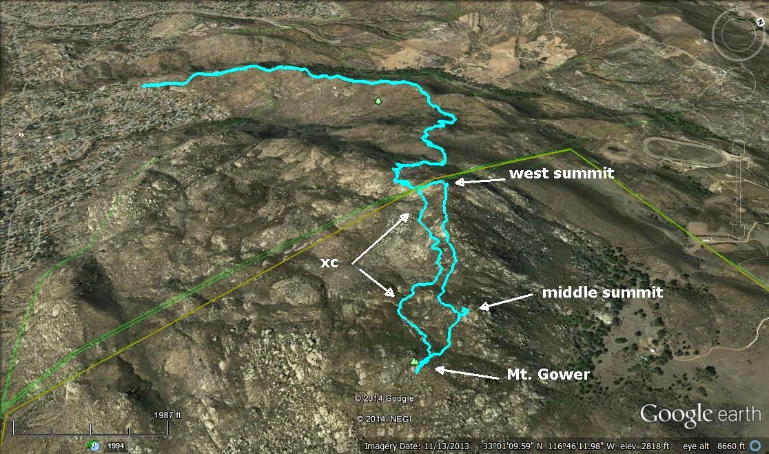
One of the many benefits of hiking in the Internet age is all the useful beta you can get on a peak. Mt. Gower is sometimes visited twice because people mistake the west summit for the true summit. Having researched this, we knew we were not done. There is also a middle summit about 0.4 miles from the west summit with a glass jar register, and finally the true summit another 0.2 miles further south. The trail ends at the west summit, so further progress requires some light to moderate cross country bushwhacking. We headed for the middle summit and found a scratchy path that approached from the far side. There were only a few entries in the register. We signed it and had a snack break. Rod launched the drone for some flybys, then we packed up and bushwhacked to the true summit. There was no register or benchmark at the summit, but there were some interesting smaller boulders. The views were best from the west summit. On the way back, we tried to find the path of least resistance, and side hilled around the other summits, reconnecting with the trail below the west summit. We made good time on the way down, though the thermometer read 100F and our feet were getting hot. It was only after I got back to the car that I realized I should have moved the register to the true summit. At home, I found a single tick had hitched a ride on me, but had not had time to attach himself. I warned Rod to make sure he didn't have any uninvited hitchhikers.
Equipment update: I took all photos with a Canon Powershot 16MP camera and kept the phone in my pack. I think the photos are improved and the camera was easy to operate.

Heading toward the middle summit, true summit in back

Middle summit register

Rod (and drone) on the middle summit

Mt. Gower summit

Looking back at the middle and west summits

Cuyamaca Peak rising in the distance

Sidehilling around the west summit

A large electric train set up in the backyard of a house below the water tower

Gower is always a fun time. Glad you went to the actual summit. :)
ReplyDeleteDerek,
DeleteYes, good fun. A little more brush than expected. I wish I would have moved the register to the actual summit so people wouldn't think the middle peak was it.