Hiked: 5/31/2013
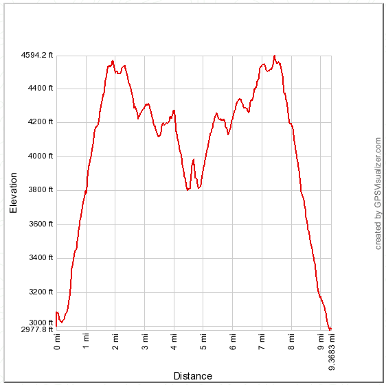
Distance: 9.4 miles round trip on dirt road and use trail
Summit Elevation: 3947'
Prominence: 147'
Elevation Gain: 2911'
Elevation Gain (in Empire State Buildings): 2.32
Round trip time: 4 hours 20 minutes
Recommended water: 96 oz.
Parking/Fees: Adventure Pass
Difficulty: Moderate
Bald Peak is another Sierra Club Lower Peak in the Santa Ana Mountains, sitting between Bedford Peak and Modjeska along Main Divide Road. The normal route used is to go up Silverado Motorway trail toward Bedford Peak, then continue east/northeast along Main Divide Road to Bald Peak. That route is 14 miles round trip. I suspected it would be shorter to go up the Modjeska use trail from Maple Springs Road, then head north on Main Divide Road to Bald Peak. That is the route I followed and the round trip was only 9.4 miles. A bit of a surprise since my eyeball estimate was closer to 12 miles. Another surprise was the amount of shade on the lower part of the Modjeska use trail. The upper sections have no shade. Bald Peak sits right above Maple Springs Road where I parked, but there is no direct way up the steep canyon walls covered in chaparral. Glad I used bug spray today because they were out in force from start to finish.
I went over two unnamed bumps before reaching Bald Peak. On the bump at 4330', I found a veterans war memorial stone, hat, and flag set up. I don't know what the date means, and the blue lettering is no longer readable. It is an interesting memorial in such a remote location.
I ascended Bald Peak from the south fire break, but it was very overgrown and I had to wade through deep grass much of the way and noticed the tail of an unidentified snake (not a rattlesnake) moving out of my way. I suggest using the nicer northeast use trail, which I did on return. I took a short break at the top, signed the register, and found a one dollar bill stuffed in the zip lock bag with it. According to the register, someone named Xavier Kurl(sp?) left it there in March, 2013 but without explanation. After taking a picture, I stuffed it back in the bag with the register. The log went back to 2001. This little peak that sits on the border between Riverside and Orange Counties doesn't see as much traffic as many of the others. The benchmark has both counties listed on their corresponding sides. The only other person I saw today was someone on a dirt bike zooming down Maple Springs Road. The return was uneventful, but the temperature warmed up to 80F before I got back to my car.


Looking forward to doing this hike tomorrow!
ReplyDeleteUnknown,
ReplyDeleteAre you going the Sierra Club route (from Bedford) or my route that starts toward Modjeska? Either way, great views down the canyon and a pretty remote peak. Enjoy.
I don't know if you will see a comment on a post this old, but it's worth a shot: do you know if anyone has ever taken the "direct route" from the start of your GPS track straight up the little gully (at least, it looks like one on the topo maps), or maybe up the ridge to the SW of Bald?
ReplyDeleteSteve,
DeleteAs far as I know, no one has ever gone that way. I stopped on the side of the road to check out that gully, got about 200' up and decided it was too overgrown. Looking over the side from the road above, I can tell you it is very brushy and very steep. Let me know how it goes if you give it a try.