Hiked: 9/30/2016
Distance: 20.9 miles round trip on trail
Summit Elevation: 2616'
Elevation Gain: 3900'
Elevation Gain (in Empire State Buildings): 3.12
Round trip time: 9 hours
Recommended water: 200 oz.
Parking/Fees: Adventure Pass
Difficulty: Strenuous
In Jerry Schad's book Afoot and Afield in Orange County, he described a one way hike from the San Juan trailhead on Ortega Highway to the Verdugo Trail to Fisherman's Camp as the Bluewater Traverse. He contemplated the possibility of climbing Peak 2616 near Oak Flats and possibly doing a giant loop back on the overgrown (at the time) North Tenaja trail. We planned to complete the giant loop, completely circling Bluewater Canyon in the San Mateo Wilderness. Few people have done as much to showcase and advance hiking in Orange County and San Diego County as Jerry Schad. For me, this was a tribute hike for Jerry Schad, who passed away in 2011 at the relatively young age of 61.
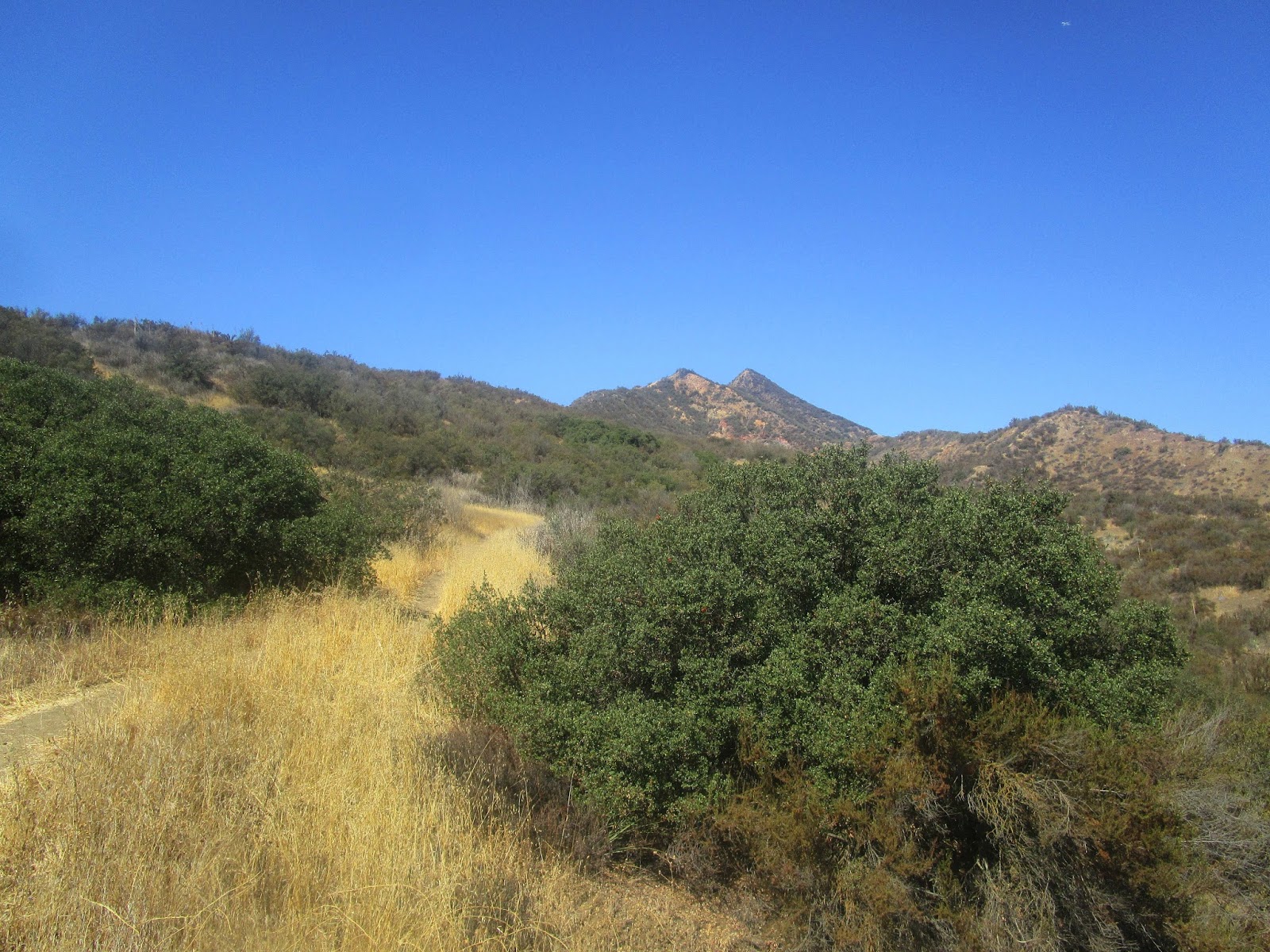
We started in the dark from the parking lot across from the Candy Store on Ortega Highway. The most dangerous part of the hike was at the very beginning when we had to cross the highway to get to the trail. There was an endless stream of commuters heading toward Orange County and there was no crosswalk or stoplight. After waiting more than 5 minutes, there was no break in the traffic. Finally, a car stopped and let us across the road. By the time we got to 4 corners, dawn had arrived and we put away our headlamps. We each cached a small amount of water for the return trip, then started down the Verdugo trail. The well maintained trail snaked around side canyons before the junction with Bluewater trail. We continued on the Verdugo trail so we could climb Peak 2616. Just before the peak, the signed Lucas Canyon trail came in from the direction of Ortega highway. I had not heard of this trail and it wasn't on anyone's map. Peak 2616 was a grassy hill, a 5 minute diversion, though it is fairly remote from any trailhead. Nothing marked the summit, but views were good in every direction, including the ocean and Catalina. We dropped off the peak and followed the wide trail to Oak Flats. Tall oaks and grassy fields seemed out of place inside the uniform blanket of chaparral that covered the surrounding area. From Oak Flats, we grabbed the Bluewater trail again for the sudden and steep 1500' descent into Bluewater Canyon. For just under a mile, the shaded trail traced the canyon, crossing the dry stream several times before hitting San Mateo Creek.
I was surprised to find the junction at San Mateo Canyon signed, with distances listed to nearby destinations. I expected this remote area to be less maintained. About 0.7 miles upstream, we arrived at the North Tenaja trail junction. Again, I was surprised not only by the signage, but the clearly maintained North Tenaja trail. Jerry Schad's report from 1995 described this trail as "too overgrown for most hikers." Dima had hauled some loppers all the way, only to find them unneeded. He seemed a little disappointed. We kicked around the idea of taking a side trip over to Fisherman's Camp, but the temperature had risen to an uncomfortable level, the tail end of a very hot Santa Ana wind event. The steep 1300' climb to the parallel ridge along Bluewater Canyon had no shade and was somewhat unpleasant. Sean might have chosen a different set of words to describe it. Once on the ridge, though, the rest of the gain was mild, spread over a long distance. From the North Tenaja trail, I got some great views into Bluewater Canyon. Several sections looked clear, unclogged by debris. This was encouraging for a future trip into the untamed canyon. The only unusual sight on the way back was a newer pair of women's running shoes abandoned in the center of the trail. This was about 3 miles away from 4 corners on a lightly traveled trail. We jokingly started looking around for the body. Sean decided to pack the shoes out, but the mystery remains unsolved. Back at 4 corners, we collected our cached water and took the longer Bear Canyon Ridge trail out. Crossing Ortega back to our cars was troublesome again, with traffic flowing the other direction. It's an extra hazard during commuting hours.
Saturday, October 1, 2016
Friday, September 16, 2016
Star Benchmark
Hiked: 9/16/2016
Distance: 9.3 miles round trip on dirt road and cross country
Summit Elevation: 1942'
Elevation Gain: 1900'
Elevation Gain (in Empire State Buildings): 1.52
Round trip time: 4 hours 40 minutes
Recommended water: 64 oz.
Parking/Fees: Free on Black Star Canyon Road
Difficulty: Moderate
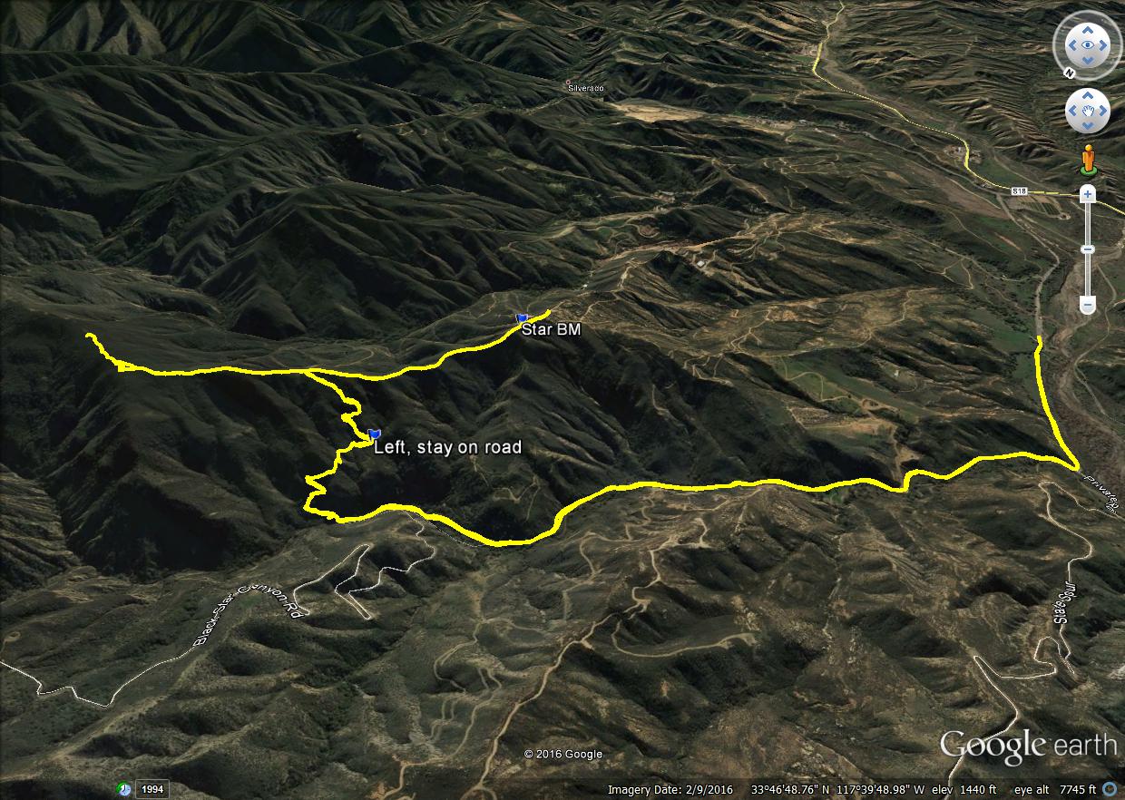
On two different hikes up Black Star Canyon Road, I noticed the switchbacks of an abandoned road or trail on the east wall of Black Star Canyon. It was not shown on any map, but looked like it might lead up to the ridge and allow access to a benchmark at 1942'. Roads leading to 1942' from the other side were gated, signed, and surrounded by electrified barbed wire. The satellite view left parts of the canyon wall in darkness so I decided to explore the trail to see if there was a way through. If I got to the ridge, I also wanted to scout the firebreak leading the other way to see if it could be used for a future hike to peak 2829. The round trip to Star benchmark alone is about 7.6 miles.
Noel met me at the Black Star trailhead and we headed up the road. When we descended into Black Star Canyon itself, the trail we wanted to explore was almost directly across the canyon, above a 10' dirt embankment. We scrambled up and began following a use trail that had clearly seen some human traffic. The first two switchbacks take you near a cliff face with light bushwhacking. The next section led to a complete wash out with thicker vegetation. We found our way through, then entered the satellite black out zone. I had drawn my own GPS track on a map and brought it with me, guessing where to go from here. The track had us continuing downhill toward a road cut across the next gully, but we saw what looked like the continuation of our road and another switchback above us. We talked it over and decided to stick to the devil we knew. The bushwhacking was moderate in this section and we had to negotiate another complete washout at the next turn. The vague trail along the road here could have been animal or human. The overgrown road made a final turn and took us up to the ridge.
The ridge was more than a wide firebreak, it was a driveable road. We headed toward the giant cross and found the USGS Star benchmark on the high point just before. The views were great from here, and although there was no register, two small cairns framed the benchmark. Other hikers had been here. As we walked over to investigate the giant cross, we noticed there were other large crosses set up at various points around the summit. There were also some on a road leading up. There were scriptures stapled to some of the crosses. The giant cross was about 40' tall, constructed of what looked like railroad ties. A dedication plaque was at the foot of it that read "The Cross, dedicated to Gary Taylor, 1946-1999". It was covered in bird shit. The rocky bluff along Baker Canyon to the south was cool looking. The benchmark is inside the national forest boundary, but it might be part of an in-holding. I'm still not sure if this place is on public or private land, but based on the lack of signs, would guess public.
On the way back, we continued past the descent point to see what condition the firebreak was in going the other way. Noel stopped at the first bump and headed home while I continued to explore the ridge. I reminded him to watch out for snakes, a helpful hint he could have done without. Beyond the first bump, heading NE, the brush started intruding. Light at first, then moderate until I stopped on a high point around 2300'. I took a couple of photos of the ridge and peak 2829. I knew the firebreak continued at least to the next bump, but I didn't see anything encouraging past that. It looks nasty from both directions, but the Hidden Ranch route might be better. I had done enough scouting, turned around and cleaned up two mylar balloons on the way out.

One of many small crosses, the latin translates to "Jesus Christ King of the Jews",
the second line is Greek (same meaning), and the bottom I would guess is Hebrew
Distance: 9.3 miles round trip on dirt road and cross country
Summit Elevation: 1942'
Elevation Gain: 1900'
Elevation Gain (in Empire State Buildings): 1.52
Round trip time: 4 hours 40 minutes
Recommended water: 64 oz.
Parking/Fees: Free on Black Star Canyon Road
Difficulty: Moderate
On two different hikes up Black Star Canyon Road, I noticed the switchbacks of an abandoned road or trail on the east wall of Black Star Canyon. It was not shown on any map, but looked like it might lead up to the ridge and allow access to a benchmark at 1942'. Roads leading to 1942' from the other side were gated, signed, and surrounded by electrified barbed wire. The satellite view left parts of the canyon wall in darkness so I decided to explore the trail to see if there was a way through. If I got to the ridge, I also wanted to scout the firebreak leading the other way to see if it could be used for a future hike to peak 2829. The round trip to Star benchmark alone is about 7.6 miles.
Noel met me at the Black Star trailhead and we headed up the road. When we descended into Black Star Canyon itself, the trail we wanted to explore was almost directly across the canyon, above a 10' dirt embankment. We scrambled up and began following a use trail that had clearly seen some human traffic. The first two switchbacks take you near a cliff face with light bushwhacking. The next section led to a complete wash out with thicker vegetation. We found our way through, then entered the satellite black out zone. I had drawn my own GPS track on a map and brought it with me, guessing where to go from here. The track had us continuing downhill toward a road cut across the next gully, but we saw what looked like the continuation of our road and another switchback above us. We talked it over and decided to stick to the devil we knew. The bushwhacking was moderate in this section and we had to negotiate another complete washout at the next turn. The vague trail along the road here could have been animal or human. The overgrown road made a final turn and took us up to the ridge.
The ridge was more than a wide firebreak, it was a driveable road. We headed toward the giant cross and found the USGS Star benchmark on the high point just before. The views were great from here, and although there was no register, two small cairns framed the benchmark. Other hikers had been here. As we walked over to investigate the giant cross, we noticed there were other large crosses set up at various points around the summit. There were also some on a road leading up. There were scriptures stapled to some of the crosses. The giant cross was about 40' tall, constructed of what looked like railroad ties. A dedication plaque was at the foot of it that read "The Cross, dedicated to Gary Taylor, 1946-1999". It was covered in bird shit. The rocky bluff along Baker Canyon to the south was cool looking. The benchmark is inside the national forest boundary, but it might be part of an in-holding. I'm still not sure if this place is on public or private land, but based on the lack of signs, would guess public.
On the way back, we continued past the descent point to see what condition the firebreak was in going the other way. Noel stopped at the first bump and headed home while I continued to explore the ridge. I reminded him to watch out for snakes, a helpful hint he could have done without. Beyond the first bump, heading NE, the brush started intruding. Light at first, then moderate until I stopped on a high point around 2300'. I took a couple of photos of the ridge and peak 2829. I knew the firebreak continued at least to the next bump, but I didn't see anything encouraging past that. It looks nasty from both directions, but the Hidden Ranch route might be better. I had done enough scouting, turned around and cleaned up two mylar balloons on the way out.
One of many small crosses, the latin translates to "Jesus Christ King of the Jews",
the second line is Greek (same meaning), and the bottom I would guess is Hebrew
Thursday, September 8, 2016
Ladyface
Hiked: 9/8/2016
Distance: 2.2 miles round trip on use trail
Summit Elevation: 2036'
Prominence: 1066'
Elevation Gain: 1213'
Elevation Gain (in Empire State Buildings): 0.97
Round trip time: 1 hour 20 minutes
Recommended water: 32 oz.
Parking/Fees: Free on Kanan Road
Difficulty: Easy (scrambling required)
Caution: There are parts of this hike that require using your hands for balance and scrambling over rocks and loose dirt. Not family friendly.
I had a long drive home from Gaviota Peak, so I found this small bonus hike that could also break up my drive. It is in Agoura Hills just south of Ventura, only a mile or so from highway 101. The profile of this small peak is supposed to resemble a lady's face, ergo Ladyface, but unlike Indianhead, I had a hard time seeing it. It also sports more than 1000' of prominence. There is a well traveled use trail starting from Kanan Road. A dirt strip turn out on the right side of the road at the trailhead accommodates 5-6 cars. There was only one other vehicle parked there so I had no issue. At the beginning, it looks like there are two big bumps with the summit being the second bump, but that was misleading. I passed the first bump and got a good look at the second. The direct route had about 25' of legit class 3, an unexpected and pleasant surprise. There was a bypass trail to the left, but it looked more sketchy than going up the good volcanic rock. At the top of the second bump, it became clear that it was a false summit.
The third bump, had it been the summit, could have been another nice section of class 3. However, as I got near, I saw the use trail leading around it to the slightly higher true summit further along the ridge. The true summit required no climbing. I continued over it a short distance to make sure it was the top and to look around for any markers. I didn't find any and I didn't find a register. I suspect this fun, short, ridge scramble is very popular in the area. I returned to the summit to relax and enjoy the scenery a few minutes before starting back. The views were nice, though my photos were a little polluted from the bright light. This hike was fun and salvaged an otherwise lackluster day.
Distance: 2.2 miles round trip on use trail
Summit Elevation: 2036'
Prominence: 1066'
Elevation Gain: 1213'
Elevation Gain (in Empire State Buildings): 0.97
Round trip time: 1 hour 20 minutes
Recommended water: 32 oz.
Parking/Fees: Free on Kanan Road
Difficulty: Easy (scrambling required)
Caution: There are parts of this hike that require using your hands for balance and scrambling over rocks and loose dirt. Not family friendly.
I had a long drive home from Gaviota Peak, so I found this small bonus hike that could also break up my drive. It is in Agoura Hills just south of Ventura, only a mile or so from highway 101. The profile of this small peak is supposed to resemble a lady's face, ergo Ladyface, but unlike Indianhead, I had a hard time seeing it. It also sports more than 1000' of prominence. There is a well traveled use trail starting from Kanan Road. A dirt strip turn out on the right side of the road at the trailhead accommodates 5-6 cars. There was only one other vehicle parked there so I had no issue. At the beginning, it looks like there are two big bumps with the summit being the second bump, but that was misleading. I passed the first bump and got a good look at the second. The direct route had about 25' of legit class 3, an unexpected and pleasant surprise. There was a bypass trail to the left, but it looked more sketchy than going up the good volcanic rock. At the top of the second bump, it became clear that it was a false summit.
The third bump, had it been the summit, could have been another nice section of class 3. However, as I got near, I saw the use trail leading around it to the slightly higher true summit further along the ridge. The true summit required no climbing. I continued over it a short distance to make sure it was the top and to look around for any markers. I didn't find any and I didn't find a register. I suspect this fun, short, ridge scramble is very popular in the area. I returned to the summit to relax and enjoy the scenery a few minutes before starting back. The views were nice, though my photos were a little polluted from the bright light. This hike was fun and salvaged an otherwise lackluster day.
Subscribe to:
Posts (Atom)