Thursday, December 29, 2016

Fisherman's Camp, Bluewater Canyon, San Mateo Canyon

Hiked: 12/28/2016
Distance: 14.5 miles round trip on trail and cross country
Summit Elevation: 1538' (at trailhead)
Elevation Gain: 2340'
Elevation Gain (in Empire State Buildings): 1.87
Round trip time: 7 hours
Recommended water: 104 oz.
Parking/Fees: Adventure Pass
Difficulty: Strenuous (combined)

I spent a respectable amount of time this year exploring the San Mateo Wilderness. One feature that caught my imagination was Bluewater Canyon, a gorge near the center of the wilderness. The Bluewater trail enters the canyon for less than a mile, then switchbacks up toward Oak Flats. I wanted to explore the wild places in the canyon.

I parked at the Fisherman's Camp TH on Tenaja Truck Trail and displayed my Adventure Pass. To get there from I-15, exit on Clinton Keith Road, go west/southwest until it turns into Tenaja Road. In less than 2 miles, you will come to a stop sign where you need to turn right to stay on Tenaja Road. Go another 4 miles, then turn right on Cleveland Forest Road (7S01). Go past the Tenaja Trailhead for 3 more miles to the Fisherman's Camp Trailhead at a turn out on the left. The small turn out only has enough parking for 3-4 cars. The trail leads to Fisherman's Camp only 1.6 miles away at the confluence of Tenaja Canyon and San Mateo Canyon. Three trails converge on Fisherman's Camp. The first one you hit before reaching the camp. That trail leads to the Tenaja Falls trailhead. Two trails converge on the other side of the camp. One leads to the Tenaja trailhead and the other leads to San Mateo Canyon and Bluewater Canyon. One of the undeveloped camp sites at Fisherman's Camp was occupied. I greeted the two guys having breakfast by their tent and passed through to the connecting trail toward Bluewater Canyon.


Start of the trail to Fisherman's Camp


Fisherman's Camp and an empty camping spot


Trail to Bluewater Canyon on the far side of the camp


Reflections in San Mateo Canyon

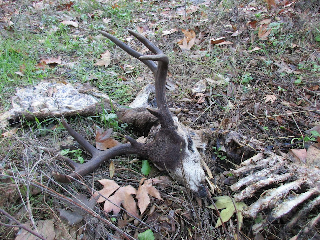
I passed the North Tenaja junction, continuing to the Bluewater Trail, then entered Bluewater Canyon. I crossed a flowing stream four or five times on the way in. The gurgling water made it seem different than the first time I was there. I quickly reached the start of switchbacks where I abandoned the trail. At first, the canyon was pretty clear. If I could not easily stay in the stream, I picked whatever bank looked the least dense and advanced slowly, switching sides as needed. I was surprised to find a pretty good use trail on the east bank, but it didn't last long. Less than half a mile from the trail, I stumbled on a deer head, an 8 point buck separated from its body but still attached to a single, long flap of fur. The eyes were still intact, but it was not a fresh kill. Part of the spine and rib cage lay next to the head. Two partial legs were about 10' away, gnawed to the bone above the ankle. About 20' away was a hip bone and the lower part of the spine. Two faint animal trails led to the feeding area, one from a side canyon and one upstream. Given the remoteness and confinement of the area, it was a little unsettling. After some photos and video, I headed upstream. The bushwhacking was only moderate. Chest high soft brush and grass mixed with dead trees. I don't remember seeing much poison oak, but maybe the vines were bare. Not far past the killing field, I found what looked like a lion day bed, about 8'x8'. And not far past that, another potential day bed. I felt like I was stomping through brush, kicking the front doors in on every house on lion street. I didn't like the tactical situation. There was only one way in and one way out. I decided this canyon was not a solo project. In the sequel, I'll return with the colonial marines.


Stream crossing in Bluewater Canyon


Start of the wild canyon


Head


Hips and spine


One of the legs


Continuing upstream


Turn around point


After retreating from Bluewater Canyon, I had some time left. Since I had not been down San Mateo Canyon, I decided to follow that trail a few miles. It was in good shape and easy to follow. Cairns marked the places to cross to the other side. Water was flowing strongly after several days of rain. Sections of the trail climbed up above the canyon, then dropped back to the bottom. San Mateo Canyon had large boulders, some larger than cars. The flowing water was broken up periodically by serene pools. I stopped at one of the scenic overlooks for a break. The trail gradually got overgrown with high grass and became more difficult to follow. I stopped at a somewhat tricky crossing, a little short of the Clark trail junction. On the way back, I climbed the largest boulder I had seen on the way out. Between the Bluewater junction and Fisherman's Camp, I saw another group of campers on the south side of San Mateo Canyon. Arguably, this area is gaining in popularity.


Rock garden


Cairns marking a crossing point


Scenic spot


Lingering color


Climbing a boulder


Weird formation across the canyon


See also:
Bluewater Canyon Reloaded

Saturday, December 24, 2016

Manza Benchmark

Hiked: 12/23/2016
Distance: 4.3 miles round trip on trail and cross country
Summit Elevation: 5556'
Elevation Gain: 1048'
Elevation Gain (in Empire State Buildings): 0.83
Round trip time: 2 hours 20 minutes
Recommended water: 32 oz.
Parking/Fees: Adventure Pass
Difficulty: Easy

Manza Benchmark is another SDC peak that starts on Sunrise Highway. The Sunset Trailhead is only a few miles from Wooded Hill. There was ample parking on the side of the road and a few other cars were parked there, though I didn't see anyone during the trip. While it is a short hike, Manza had a reputation for giving people route finding fits, so I gave it plenty of respect. When I started, the temp was 37F with a light mist falling. Clouds hid everything more than a couple hundred feet away so it became a GPS navigation exercise. I didn't want to risk my camera in the mist, so I took most photos with my allegedly water resistant phone. The phone survived the water just fine.

The sunset trail goes left at the first split, which comes quickly. I went right and had to make a course correction. Enticing boulder piles appeared not far from the trail but I stayed focused on Manza. Multiple vague use trails branched off in several directions. I knew there was supposed to be a short cross country section down a drainage to find the clipped use trail up to Manza. I also knew that finding that trail was paramount. The trail started dropping and I looked for signs of a path into the drainage. I found what looked good enough and left the trail. When I thought I was close to the bottom of the drainage, I started poking around in the brush, not finding the cut use trail. I continued further down the drainage over a large fallen tree and the path appeared under my feet.


Sunset trailhead


Trail going around a large boulder


Wet pine forest


Leaving the trail toward the drainage


Continue past this tree to find the clipped trail

The use trail followed the drainage a little more before turning uphill near a barbed wire fence. A cool rock feature marked the first false summit. More use trails branched away from the main trail. I could see how navigation might be a problem, but the GPS kept me on the right path. The bushwhacking was light, but even light bushwhacking through the wet brush drenched me. Water ran down my pants into my socks. So much for the water proof boots. There was a large boulder at a second false summit and I stopped to climb it. I had a lot of trouble with a simple class 2 boulder simply because there was no traction. Everything was slippery and my boots would not hold imperfections on the rock. I finally stepped on a bush to reach a crack with both hands and pulled myself up. Of course, the clouds meant there was nothing to see. A waste of time. I got back on the trail and scrambled over a few more boulders on the way to the summit. The true summit was an easy walk up. Instead of a USGS mark, there was an Army Corps of Engineers benchmark. I signed the register and added a second plastic bag for protection. On the way back, I took a better angle to the trail from the drainage. The scenery was amazingly lush and green for San Diego county.


First false summit


Manza Manzanita


Manza summit


Manza benchmark


Lousy view from the summit


Register


Descending back into the drainage past mossy rocks and green


Baby pine


Wooded Hill

Hiked: 12/23/2016
Distance: 1.3 miles round trip on trail
Summit Elevation: 6223'
Elevation Gain: 299'
Elevation Gain (in Empire State Buildings): 0.24
Round trip time: 35 minutes
Recommended water: 0 oz.
Parking/Fees: Adventure Pass
Difficulty: Easy

An unusual 4 day stretch of back to back storm systems moved into SoCal this week, throwing a wrench into my elaborate plans. I searched 100 miles in all directions for a respite from the weather and found a slight break in the action in San Diego county. There was still some low hanging fruit on Sunrise Highway, so I headed out for Wooded Hill (SDC #3) and Manza Benchmark (SDC #19). Clouds enveloped the entire area, blocking views and threatening rain. None of that mattered for this super short first outing. Other than a drive up, it doesn't get easier than Wooded Hill. It's a gentle nature trail through a nice pine forest ending in some small summit boulders. A longer trail starts with the official signs while a more direct trail starts about 50' to the right. I took the short route and was back at the truck in 35 minutes. I am guessing this is the most family friendly peak on the San Diego Peaks list. While the area is nice, it's hard to believe it made the same list as San Ysidro East and Eagle Crag.


Start of a short trail


Even shorter trail


Summit boulder pile


Summit view of a very Wooded Hill

Saturday, December 17, 2016

Tongva Peak and Mt. Thom

Hiked: 12/12/2016
Distance: 6.2 miles round trip on trail
Summit Elevation: 2656' (Tongva), 2440' (Thom)
Elevation Gain: 1700'
Elevation Gain (in Empire State Buildings): 1.36
Round trip time: 2 hours 5 minutes
Recommended water: 24 oz.
Parking/Fees: Free on Beaudry Terrace
Difficulty: Easy

I had a few hours in Pasadena while my wife was at a professional conference. I was still recovering from a big outing in Anza-Borrego less than 48 hours prior, so I decided to do something light in the eastern Verdugo Mountains. I discovered the Beaudry Loop Trail from a peakbagger post by Mihai Giurgiulescu, thanks! The Beaudry Loop Trailhead starts near 3110 Beaudry Terrace in Glendale on a paved section of road that looks like a driveway. There was ample parking on both sides of the street. The paved road headed uphill to a wide, smooth dirt road.

Maple trees were showing off reds and yellows near the start. SoCal does have seasons, well, sort of. After a few switchbacks, the signed trail split into Beaudry Motorway North and South. I took the North road to hit Tongva Peak first. The day was a hazy shade of winter, overcast and cool with low clouds obscuring the Verdugos. It was comfortable hiking weather but bad for views. The road was one of the smoothest trails in recent memory with hardly any rocks larger than a marble. An uneventful stroll led to the antennae on Tongva Peak. A barbed wire fence surrounded the towers but not completely. The fence could be walked around on the south side but I didn't see the point. A summit plaque and bench were at a lookout point just south of the towers. No register was present. As expected the views were poor. I hung out on the bench a few minutes before heading toward Mt. Thom, maybe a half mile away.


Trail starts up what looks like a driveway


Maples


Beaudry north right, south to the left


Approaching Tongva Peak


Tongva towers


Summit plaque

Mt. Thom had a more serious fence with three strands of barbed wire wrapped in two coils of razor wire. This one completely surrounded the summit and a newer looking tower. I stopped at the fence and snapped a photo, only reading the warning after that the summit was considered critical infrastructure by Homeland Security and had audio and video monitoring equipment. Not a friendly summit at all. I headed down South Beaudry Motorway, following the twisty road around numerous small bumps. I caught infrequent glimpses of Burbank and Glendale through the clouds on the way down.


Approaching Mt. Thom


Visitors not welcome


Hazy view of downtown Burbank


Looking back