Hiked: 12/22/2017
Distance: 8.4 miles round trip on dirt road and use trail
Summit Elevation: 1662' (high point in canyon)
Elevation Gain: 1340'
Elevation Gain (in Empire State Buildings): 1.07
Round trip time: 4 hours
Recommended water: 48 oz.
Parking/Fees: Free on Black Star Canyon Road
Difficulty: Moderate
Rod hadn't been to Black Star Canyon Falls, so I asked him if he wanted to do a quick trip to the Falls with a side trip up the east fork of Black Star Canyon. It had been five years since my last trip to the falls and I had never gone up the east fork. I won't spend much time on the hike to the falls because it has been extensively documented in many places. In the last five years, a metal sign had been installed to show people where to drop into the canyon and a small sign was placed at the fork to point people toward the falls. The sign at the fork was covered in graffiti. When we got to the falls, a couple of parties were already there. There was a little more boulder hopping than I remembered. The falls were predictably dry due to our lack of rain. We took a short break then headed back to the fork.
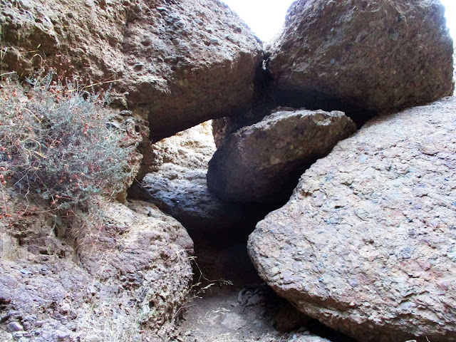
We headed up the east fork and found a good use trail. This way looked almost as traveled as the main route. A little more than a quarter mile up, we ran into our first real obstacle. A large set of boulders with a natural tunnel on the left. A class 2+ stem got us up and out of the tunnel. While the canyon was fairly narrow, it wasn't filled with debris and run off like I've seen in many other Santa Ana canyons. The good use trail resumed above the boulders. The second obstacle we ran into was a little more serious. A giant 20' boulder filled the canyon. There were crumbly class 4 options on the left and right, but there was also a rope hanging down a steep dirt slope before the boulder on the left. The rope looked like 7-8mm cordelette and disappeared into the trees above. We could not see where it was anchored.
Rod tested the rope and without debate began climbing. The rope wasn't really necessary on the way up, though it did provide some peace of mind. At the top, it was attached to a blue rope that was tied in a tangle of knots around a healthy 4" limb. I didn't recognize the knots used, they looked haphazard. The ropes seemed to be in good shape and the limb was solid. Past the huge boulder, the use trail continued though it was less clear. Still, it was easy going all the way to the second fork. Rod needed to get back so we turned around at the second fork, but both directions looked clear at least another 150'. I was very surprised by how clear the east fork of the canyon was. On the way back, we met a couple at the bottom of the large boulder who didn't like the looks of it. Rod and I both used arm rappels to descend and the rope was very useful for this purpose. After talking to the couple, we learned they were looking for the falls and took a wrong turn at the fork. They reversed course and followed us out. Rod and I both agreed that the east fork was more fun than the main route to the falls.
Update: 9/2/2018
I returned to the East Fork to explore past where Rod and I stopped last time. I returned partly for the exploration and partly to burn some calories. The rope at the dirt wall was gone so I had to climb it without aid. Well, once I reached the lower tree branches, I used them as aid. At the split where we stopped last time, I continued left. While the brush and poison oak got a little thicker, it was still manageable. The use trail had faded out some distance back and coyote scat became more common. There was nothing more than class 2 all the way up to 1931', where I stopped at a large oak tree in the narrow canyon. It was possible to continue past the oak and the boulder behind it, but I had achieved my calorie burn goal so I turned around. On the way back, I went about 100' up the right fork until I hit some thick poison oak. It is intriguing that the canyon remained as clear as it was up to the big oak.


No comments:
Post a Comment