Sunday, October 20, 2024

Indianhead via East Ridge

Hiked: 10/17/2024
Distance: 7.6 miles round trip on trail and cross country
Summit Elevation: 3960' (Indianhead), 2925' (Borrego Point)
Elevation Gain: 4285'
Elevation Gain (in Empire State Buildings): 3.4
Round trip time: 11 hours
Recommended water: 164 oz.
Parking/Fees: $10 State Parks Day Use Fee
Difficulty: Strenuous

My original plan was to climb Spanish Needle in the southern Sierra. But, there was a hazardous wind warning with 35mph gusts. Not ideal for the serious scrambling involved. Instead, Henry Chen and I decided to try a new route on the east ridge of Indianhead (DPS #83, SDC #50) in Anza-Borrego. I had climbed Indianhead twice: the standard DPS route B up Palm Canyon, and also the north ridge (the easiest route), but this would be Henry's first time on the mountain. We started shortly after sunrise around 7:00 AM. I suggested we start on a slope that looked like a better approach to the first bump on the east ridge than the ridge proper. Henry agreed. The first mile was steep, 1700' of up, but presented no serious obstacles. The ridge mellowed as it rose slowly to the unofficial Borrego Point, marked with a small cairn. Then, we faced the first of three challenging bumps.


Borrego Point


We went up the gully on the right

As we got near the first bump, the slope was at a 50-60 degree angle. Even before we got there, I was planning for a bypass on the north side. When we hit the first class 4 slab, I spotted a gully a couple hundred feet north that looked class 3. Before heading there, I scrambled up a wedge closer to the edge. There were two kinds of rock: whiteish chossy rock and varnished granite that felt solid. The wedge was whiteish rock and crumbly. I decided to downclimb about 100' to reach the gully. Henry climbed one of the red boulders to explore above. The gully was easier and less exposed than the ridge and I made good time. Henry didn't like the continuation, so he dropped down and came up behind me. We made steady progress and reached the second major bump. We got very near the top of the second bump when we hit the next class 4 section. There were two options and both hung over a 300' cliff. This was a harder decision. We were so close to the top, and the downclimb to get around this one was about 400' down. Way, way down. After careful consideration, I decided it was too risky and started the longest downclimb of the day. Periodically, I checked the edge of the gully to see if I could reach it, then kept going lower. Finally, we reached the safer gully. It wasn't clear that we could make it back to the ridge from there. I informed Henry that if we turned back again, I'd have to bail due to lack of water. Fortunately, we made it to the ridge and proceeded to the last major bump. I didn't seriously probe the rocks on top, but looked for downclimb number three on the north side. I dropped through a little portal, down a slab going away from the summit, then skirted the side of the bump to attain the ridge about 200' below the top. Looking back, it might have been possible to go over the last bump without undo risk.

Steep terrain


Looking down on the bypass gully


Another nope


Summit ahoy

Through the portal

Looking back at the final obstacle on the east ridge

With GPS, I confirmed the bump in front of us was indeed the summit. The south summit started to look familiar and I breathed a deep sigh of relief. The tough terrain had cost us about two hours, but now I was on familiar ground. We signed in and took a well earned respite. We started down the NW ridge, the standard DPS route B. About half way down, I decided the gully looked closer than sticking to the standard route on the ridge. As I started down, I found it too loose, a poor decision. Before I got too far, I decided to angle back up to the ridge. Henry was well behind me but knew what my intent was. It was bad luck that he didn't see me going back up. When I got down to the canyon, I could not see him anywhere. I waited a few minutes then starting yelling for him. I heard him answer and spotted him coming down a nasty dry waterfall in the gully. He had followed my bad decision without seeing my correction. He said there was more class 4 in the gully, a hard way to get off the mountain. We followed a use trail for over a mile to reach the main oasis where the state park trail took over. It was another relief to hit the official trail for an easy finish. The east ridge was fun and challenging, but a one and done for me. It was by far the most difficult of the three routes I've done. I felt remarkably good after a grueling day, but expected to be sore over the next 48 hours.

Indian head penny stamps on the cover

Two on top

South summit


Henry almost down


Would you like to know more...?

See Also:
Indianhead via DPS Route B
Indianhead via North Ridge

Friday, October 11, 2024

Rouse Hill and Rouse Ridge

Hiked: 10/9/2024
Distance: 11.5 miles round trip on dirt road and use trail
Summit Elevation: 5168' (Rouse Hill), 5464' (Rouse Ridge)
Elevation Gain: 2150'
Elevation Gain (in Empire State Buildings): 1.7
Round trip time: 4 hours 15 minutes
Recommended water: 80 oz.
Parking/Fees: Free on Forest Route 5S15
Difficulty: Moderate

After Thomas Mountain, I planned to drive most of the way to Rouse Hill (HPS #265) on Forest Route 5S15, which takes a sharp right turn at the intersection with 6S18. There was a locked gate at the intersection with a Road Closed sign, but also a wide path around the gate. I stopped and saw a posted sign stating that the road was closed due to a fire order. The post listed a phone number for the San Jacinto ranger district. I had one bar of signal and I made three attempts to call the ranger station, but none of the calls went through. I debated whether to drive around the gate, eventually deciding to park and walk the road to Rouse Hill. I only realized later looking through photos that the fire closure also included foot traffic. Oops. The GPS showed Rouse Hill was 4 miles away (as the crow flies), but it turned out to be farther on the road. A mile from the intersection, I left the road on the south side to tag a Peakbagger point, Rouse Ridge. I found an old register in some cans and signed it. The road remained flat for a while, then started to wind downhill. I turned a corner and spotted Rouse Hill across a valley. There were good views along the way of the Santa Anas and San Jacinto. The road got steadily worse: no big rocks, but deep ruts and washouts. I'm not sure I could have driven it all the way. When I reached the top of the road, I found a triangle pole marker and thought I was there. However, Rouse Hill was the next bump over and may not be the local high point. It was hard to tell. I waded through some tall grass to a group of rocks where I found the benchmark and a reference mark. The last signature in the register was from February. I rested about 15 minutes, then started back. There was more gain than I remembered on the way back and I worked up a lather during the hottest part of the afternoon. I had plenty of water, though, and made it back in good order.


Looking back at Thomas Mountain from Rouse Ridge

Santa Ana Mountains in the distance

Rouse Hill far left


Rouse Hill summit

San Jacinto


Thursday, October 10, 2024

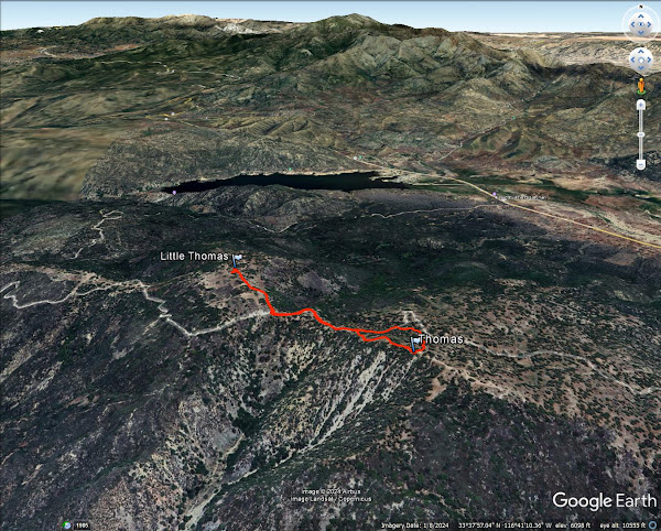
Thomas Mountain and Little Thomas Mountain

Hiked: 10/9/2024
Distance: 2 miles round trip on dirt road and use trail
Summit Elevation: 6825' (Thomas), 6572' (Little Thomas)
Prominence: 1945' (Thomas)
Elevation Gain: 530'
Elevation Gain (in Empire State Buildings): 0.4
Round trip time: 1 hour
Recommended water: 16 oz.
Parking/Fees: Free on Forest Route 6S13
Difficulty: Easy

I drove near Idyllwild to hit two HPS peaks in the area: Thomas Mountain (HPS #128) and Rouse Hill (HPS #265). Both are ostensibly drive ups. From Highway 74, I took Forest Route 6S13 to the junction with Little Thomas Road and parked there. The road was good shape, but high clearance helped in a few spots. It was 0.6 miles round trip to Little Thomas on Little Thomas Road. A small weather station was near the top, but the high point was just off the road in a small pile of boulders. Pine trees blocked views in most directions. No marks and no register. I appreciated the pines, but there wasn't much else to recommend Little Thomas. I returned to the truck and continued past it toward Thomas Mountain. The road made a long switchback before coming back to Thomas, so I started uphill when I was directly below it. It was open country with a bed of pine needles. When I reached the upper road, I saw a Jeep driving down. The summit had a picnic table and fire pit. Like Little Thomas, it was pleasant, but most views were obscured by trees. No marks and no register. I spotted a use trail going down the ridge so I followed it. The trail was in decent shape and was better than my ascent path. Visiting both peaks took an hour. Next up was Rouse Hill.

Little Thomas Road

Little Thomas summit

Heading to Thomas Mountain

Cross country shortcut

Thomas summit

San Jacinto


Tuesday, October 8, 2024

Vetter Mountain, Mount Mooney, and Devil Peak

Hiked: 10/4/2024
Distance: 7.6 miles round trip on paved road, dirt road, use trail, and cross country
Summit Elevation: 5908' (Vetter), 5849' (Mooney), 5896' (Devil)
Elevation Gain: 1350'
Elevation Gain (in Empire State Buildings): 1.0
Round trip time: 3 hours
Recommended water: 48 oz.
Parking/Fees: Adventure Pass or National Parks Pass
Difficulty: Moderate (combined)

My other goal for the day was Vetter Mountain (HPS #191) with a central fire lookout tower. I parked at the Charlton Flats picnic area and displayed my National Parks pass. There was a restroom at the parking area. Behind the locked gate, a paved road goes to the base of Vetter. The final quarter mile is a dirt road. Along the way, there were multiple picnic tables and benches. Each one had a restroom, but when I looked inside one, it looked unmaintained and filled with construction equipment and materials. No one was using any of the facilities. The only interesting thing I saw on the hike to Vetter was a giant pile of bear scat. The fire lookout looked clean and new, probably the nicest I've seen. The only tower I've seen that came close was the one on Slide Mountain. A volunteer named Andy was working and he invited me in to look around. He explained the Osborne fire finder, a mechanical wheel that let's you sight and locate a fire (via trigonometry). He said they were always looking for volunteers, and they provided extensive training every March. I said I would consider it. I never realized how central Vetter was and what great 360 views it had. I spent about 20 minutes talking with Andy and forgot to look for a benchmark. When I got back to the truck, I still had plenty of time left so I decided to head for Mooney and Devil peak on the other side of ACH.


Bear scat

Vetter ahead


Osborne fire finder


A dirt road heads up toward Mooney (HPS #198). The gate was open and I could have driven to the base of it, but I didn't. I thought about going up the firebreak and that would have been shorter, but the area was overrun with whitethorn and the firebreak might not have been worked. From the base, I followed a use trail to the flat summit. A pair of black cans held the HPS register. With only 229' of prominence, Mooney doesn't technically quality as a standalone peak. Most of it had burn scars and the views were not special. Hard to believe this was an actual HPS peak. "Toasted Turd" might be a better name for it. Somewhere on Mooney, I accidentally put my camera into portrait mode, which blurred the edges. It mostly ruined the photos.


I returned to the road, then went around a gate toward Devil Peak (not an HPS peak), less than a mile away. I passed a small observatory I didn't know existed. At the end of the road, a firebreak led to the top of Devil. There were a lot of downed trees, burned and decayed. Poodle dog and whitethorn were also in abundance, but a use trail made it navigable. Views from the top were OK, but blocked by trees and brush to the west. I found a cairn at the summit, but no marks and no register. The firebreak continued down the south side. I spent 5 minutes on top, then returned to the truck. Mooney and Devil were ugly peaks, but I still had fun.

Devil Peak


A hundred sports cars were racing on the ACH.
This one hit a wall.