Tuesday, May 31, 2022

Mitchell Peak

Hiked: 5/28/2022
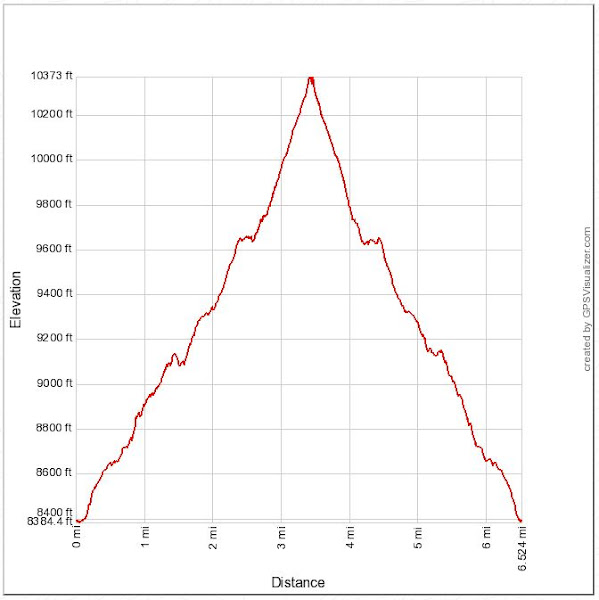
Distance: 6.5 miles round trip on trail
Summit Elevation: 10365'
Prominence: 1205'
Elevation Gain: 2235'
Elevation Gain (in Empire State Buildings): 1.8
Round trip time: 4 hours
Recommended water: 54 oz.
Parking/Fees: $35 National Parks Fee (one car for 7 days)
Difficulty: Moderate

Mitchell Peak is an obscure Sierra peak just outside Kings Canyon in the Jennie Lakes Wilderness. While not technically in a national park, you need to drive through Kings Canyon to reach the Marvin Pass trailhead, incurring the entry fee. We've been buying national parks annual passes the last few years to save a bundle. To reach the trailhead, we drove the Generals Highway to forest road 14S11 (paved single lane road) to 13S12 (dirt single lane road). The dirt road portion was 2.7 miles. While high clearance is recommended, someone got an Audi crossover there. We were one of four vehicles at the trailhead, a welcome break from the Memorial Day crowds at easier to reach attractions.

Leisa and I started at 8:00 AM at the same time as a solo hiker. The solo hiker pulled ahead of us at the start of the trail, but everyone was breathing heavily from the high elevation (9104') start. The Kanawyer trail goes through dense cedar and pine forests and we were in shade until we reached the north ridge of Mitchell. There was quite a bit of deadfall along the trail, but none of the obstacles were serious. The Mitchell peak trail cuts across the west ridge and goes well north of the peak before circling back. It looked possible to pick your way directly up the ridge, but the trail was short enough that I didn't suggest it. The trail got less distinct on the ridge and we found the sharp south switchback with a quick GPS check. There were patches of snow lingering in various places along the trail. The trees thinned as we got closer to the summit. The final section was above the tree line across a jumble of gray granite.


There were snow plants all along the route

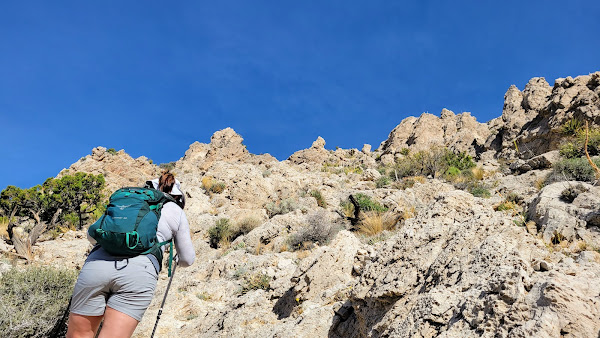
Approaching the summit boulder pile

As we reached the top, 360 views of the central Sierra unrolled. Immedfiately south, we saw snow covered Alta Peak (11204') that we had climbed the previous year, and Mount Silliman (11188') that was on our to do list. Mount Maddox was next door, the Kaweahs and North Palisade were also visible, though distant clouds made some them hard to see. It was a huge payoff for the effort. Several reference marks were intact as well as the benchmark. A square concrete platform was all that remained of the fire lookout. We didn't find a register on top, but there was a register at the trailhead (for forest service use). While resting on the summit, the solo hiker that pulled ahead of us at the start appeared at the bottom of the boulders. He wondered how we had beaten him to the top, then realized he had lost the trail and gone too far north. He did not have a GPS for assistance. We all started down together. Near the bottom of the ridge, the solo hiker passed us again, having missed the trail turn a second time. Advantage GPS, even on trail. This was a wonderful hike through a remote part of the Sierra.


Mount Silliman on the right, Alta behind Silliman to the left


Solo hiker in blue shirt on his way up, North Pal in the far distance


Buck Rock Lookout

Hiked: 5/28/2022
Distance: 0.6 miles round trip on dirt road
Summit Elevation: 8502'
Elevation Gain: 350'
Elevation Gain (in Empire State Buildings): 0.3
Round trip time: 30 minutes
Recommended water: 0 oz.
Parking/Fees: $35 National Parks Fee (one car for 7 days)
Difficulty: Easy

When forest route 13S04 opens in late spring, you can drive within a quarter mile of Buck Rock Lookout. A locked gate prevents you from driving all the way to the tower. Leisa and I drove up from the Generals Highway, then hiked the road to the lookout. The dirt road has a bad reputation but was not really difficult or challenging with high clearance. A sedan or two had made it to the top. Unfortunately, afternoon clouds were blowing through and had engulfed the top of the tower. The lookout was built on top of a 300' rock spire. It would have a been a difficult rock climb to reach without metal stairs with wooden steps built into it. We walked to the top and found two rangers manning the lookout. We didn't bother them, but walked around the top hoping for a break in the clouds. After a few minutes, we cursed our bad luck and descended. According to a plaque at the bottom, wooden ladders were used when it was first operational in the early 1900s. We got a mostly clear photo of the lookout as we were leaving. Leisa talked me into chancing the northern exit on forest road 13S04 that connects to 14S02 (paved), then eventually Quail Flat. We drove out to the north and the road was no worse than the southern part and more scenic.


Saturday, May 21, 2022

Grays Peak and Hanna Rocks

HPS Star Emblem Peak
Hiked: 5/20/2022
Distance: 9.8 miles round trip on dirt road and cross country
Summit Elevation: 7920' (Grays), 7854' (Hanna)
Elevation Gain: 2250'
Elevation Gain (in Empire State Buildings): 1.8
Round trip time: 5 hours 30 minutes
Recommended water: 64 oz.
Parking/Fees: Free at 2N13 gate (unsure if Adventure Pass needed)
Difficulty: Moderate

Drove out to Big Bear Lake for Grays Peak (HPS #74), the closest remaining star emblem peak on the list. It was a bizarre weather day, with a strong marine layer extending deep into San Bernardino County. It rained the entire drive until I rose above 6000' on highway 38, then blue skies and sunny sunshine. The forest around Big Bear is mostly large evergreens making an idyllic impression. The official trailhead for Grays Peak was near Fawnskin, but was closed for eagle nesting. I had to use the back door. I took Rim of the World (eventually a dirt road) to 2N13, which was gated. There was ample parking at the gate so that was my starting point.

I walked up 2N13 until I spotted a line on the north ridge that looked good enough, then left the road. Grouse Creek was gurgling, but low, and easy to cross. My intuition was that the slopes around Big Bear were mostly open and that would cost me later. I wound around large patches of buckthorn and some deadfall. About 30 minutes later, I intersected the trail. It eventually circled the peak to ascend from the south. There was a witness post at an overlook 50' below the high point. I found a geocache below the summit block. Views of the lake and the San Bernardino Mountains were better at the overlook.

I planned to get Hanna Rocks next. The Garmin showed a road/trail nearby that turned out to be non-existent. That, plus my underestimation of the brushy slopes led me to waste an hour attempting a cross country shortcut. It ended in a mess of buckthorn with one thorn too deep in my thigh to remove with tweezers. It's still there as I write this. The only good that came from it was I retrieved a mylar balloon. I backed off and descended generally the way I came up, before following roads to the base of Hanna Rocks.


Following the ridge


Grays summit


There were only a few ascents of Hanna Rocks in Peakbagger (always a motivation!), and no GPS tracks. It looked like a fun cross country scramble. I started up the south ridge, dodging brush and climbing rocks. There were several class 3 sections before a false summit. When I reached the summit area, I thought the nearest two boulder piles were the main candidates for the high point. I picked the higher of the two, realizing at the top that an even higher pile was on the north side of the summit. I climbed down and approached the highest point, discovering a register underneath. The register had been placed by Dave Comerzan and George Christiansan on 8/10/2018. I signed in as the 6th entry, then continued up the final 15' to the true summit. Big, fat holds all the way. Views were awesome and airy. On the drive back, I descended back into the gloom of the marine layer that rained on me again.

Hanna Rocks from the north ridge of Grays

First, I had to get back to the road

Base of Hanna


Hanna summit behind the pine trees, from the 2nd highest boulder pile

Hanna summit block, register visible under boulders


San Gabriel Mountains in the distance, above the marine layer

Looking back at Grays Peak


Tuesday, May 10, 2022

Turtlehead, NV

Hiked: 5/7/2022
Distance: 4.8 miles round trip on trail
Summit Elevation: 6323'
Prominence: 603'
Elevation Gain: 2047'
Elevation Gain (in Empire State Buildings): 1.6
Round trip time: 3 hours 20 minutes
Recommended water: 48 oz.
Parking/Fees: $15 Red Rock fee (OR National Parks Pass) + $2 online reservation fee
Difficulty: Moderate

Leisa and I were in Vegas for her birthday and took one day to explore Red Rock Canyon National Conservation Area. To limit traffic, Red Rock requires a timed entry reservation. Reservations were plentiful, and we started at 8:00 AM on what would be a warm day. The loop through Red Rock is one way with hiking trails branching out from various stops. We planned two hikes that both started at the Sandstone Quarry parking area: Turtlehead and Calico Tanks.

The parking lot was only half full. Turtlehead is a prominent feature sticking up over the red and white Calico hills. Most people were hiking the Calico Tanks trail with only a few heading toward Turtlehead. A well maintained trail with plenty of signs led into a gravel wash, then into a wide drainage toward the saddle west of the mountain. Half way up the drainage, white and green paint dots marked the main route, though there are still a few signs. The trail stayed left of the main gully and there were a few use trails that might cause some confusion. Most of the gain was done by the time we reached the saddle. The final section has many braided use trail options similar to what you find near the top of the Mount San Antonio Ski Hut trail. Some are easier, some are harder, but they all end at the top. The views explode when you reach the rim of Turtlehead. Bright red rocks were spread out below and higher mountains were visible across canyons on both sides. Snow was visible on distant Griffith Peak (11060'). A plaque or marker had been pryed out of the summit and the peak was too popular for a register. We rested a while on top and soaked in the sun before heading down. It's a worthy adventure if you are in the Vegas area.


Turtlehead summit, missing marker


After we got back from Turtlehead, we took a short break, then hiked the Calico Tanks trail. The stats don't include the Calico Tanks trail, which was 2.5 miles and about 500' of gain. This trail was busier and involved some scrambling to reach the tanks where water would pool in wet conditions. The tanks were dry when we got there but had knee high green grass. We stopped at an overlook just past the tanks. On the way back, the wind started gusting strongly (40 mph) and discouraged us from taking on any other hikes. Not only was it blowing dust in our faces, it made scrambling on other routes more hazardous. We completed the scenic loop and called it a day.


Calico Tanks