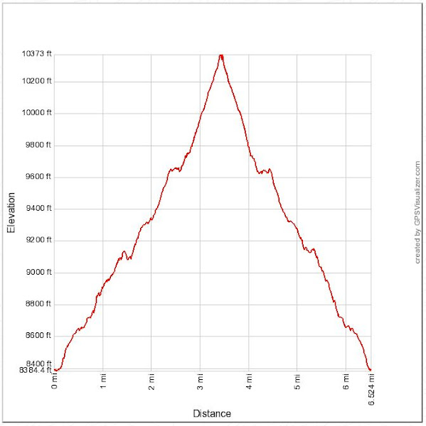
Distance: 6.5 miles round trip on trail
Summit Elevation: 10365'
Prominence: 1205'
Elevation Gain: 2235'
Elevation Gain (in Empire State Buildings): 1.8
Round trip time: 4 hours
Recommended water: 54 oz.
Parking/Fees: $35 National Parks Fee (one car for 7 days)
Difficulty: Moderate
Mitchell Peak is an obscure Sierra peak just outside Kings Canyon in the Jennie Lakes Wilderness. While not technically in a national park, you need to drive through Kings Canyon to reach the Marvin Pass trailhead, incurring the entry fee. We've been buying national parks annual passes the last few years to save a bundle. To reach the trailhead, we drove the Generals Highway to forest road 14S11 (paved single lane road) to 13S12 (dirt single lane road). The dirt road portion was 2.7 miles. While high clearance is recommended, someone got an Audi crossover there. We were one of four vehicles at the trailhead, a welcome break from the Memorial Day crowds at easier to reach attractions.
Leisa and I started at 8:00 AM at the same time as a solo hiker. The solo hiker pulled ahead of us at the start of the trail, but everyone was breathing heavily from the high elevation (9104') start. The Kanawyer trail goes through dense cedar and pine forests and we were in shade until we reached the north ridge of Mitchell. There was quite a bit of deadfall along the trail, but none of the obstacles were serious. The Mitchell peak trail cuts across the west ridge and goes well north of the peak before circling back. It looked possible to pick your way directly up the ridge, but the trail was short enough that I didn't suggest it. The trail got less distinct on the ridge and we found the sharp south switchback with a quick GPS check. There were patches of snow lingering in various places along the trail. The trees thinned as we got closer to the summit. The final section was above the tree line across a jumble of gray granite.
As we reached the top, 360 views of the central Sierra unrolled. Immedfiately south, we saw snow covered Alta Peak (11204') that we had climbed the previous year, and Mount Silliman (11188') that was on our to do list. Mount Maddox was next door, the Kaweahs and North Palisade were also visible, though distant clouds made some them hard to see. It was a huge payoff for the effort. Several reference marks were intact as well as the benchmark. A square concrete platform was all that remained of the fire lookout. We didn't find a register on top, but there was a register at the trailhead (for forest service use). While resting on the summit, the solo hiker that pulled ahead of us at the start appeared at the bottom of the boulders. He wondered how we had beaten him to the top, then realized he had lost the trail and gone too far north. He did not have a GPS for assistance. We all started down together. Near the bottom of the ridge, the solo hiker passed us again, having missed the trail turn a second time. Advantage GPS, even on trail. This was a wonderful hike through a remote part of the Sierra.


