Tuesday, April 6, 2021

Mount Inspiration

Hiked: 4/5/2021
Distance: 1.8 miles round trip on use trail
Summit Elevation: 5560'
Prominence: 800'
Elevation Gain: 882'
Elevation Gain (in Empire State Buildings): 0.7
Round trip time: 1 hour
Recommended water: 32 oz.
Parking/Fees: $30 National Parks Fee (1 car good for 7 days)
Difficulty: Easy

Leisa and I drove to Keys View, a walk up lookout. There were quite a few people at the lookout, but we walked away from it to the start of the use trail to Mount Inspiration (HPS #227). We followed the use trail up to the main ridge, then down a couple of hundred feet to the saddle below peak 5558. It was a short climb to 5558, and the use trail kind of disappears around the pile of boulders at the top. We went over/through some boulders which involved some minimal scrambling, but Leisa was not particularly happy about it, picking up some scratched legs getting over. I had not warned her about this section because I was not aware of it. Dropping to the saddle below Inspiration, we discovered a metal shed that had "fire hose" stamped on the side. The shed was locked and one of the strangest things I had seen in Joshua Tree. We continued the short distance to the summit which had a proper register, a benchmark and two reference marks. Views were again dampened by the partly cloudy skies. When we returned, we side hilled around 5558, but could not totally avoid climbing around/over a few boulders. When were approached the parking area, we met one other couple on their way up. It was a stark contrast to the zombie hordes on Ryan. Inspiration was short, but more fun than Ryan.


Fire shed

Leisa on the summit

Benchmark 1977


San Jacinto in the distance


Almost back to Keys View

Ryan Mountain

Hiked: 4/5/2021
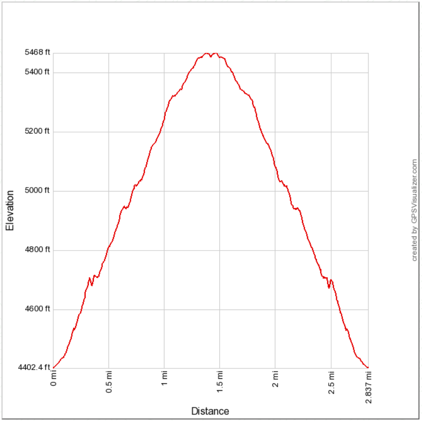
Distance: 2.8 miles round trip on trail
Summit Elevation: 5457'
Prominence: 937'
Elevation Gain: 1098'
Elevation Gain (in Empire State Buildings): 0.9
Round trip time: 1 hours 45 minutes
Recommended water: 32 oz.
Parking/Fees: $30 National Parks Fee (1 car good for 7 days)
Difficulty: Easy

This was on a family vacation to Joshua Tree for a few days. We had kids and dog in tow which limited what we could do. We took Shelby and the dog on a short trail outside the park in the morning. In the afternoon, Leisa and I decided to hit up some of the easy HPS peaks in the park. Since it was spring break, the park was swarming with people. Ryan Mountain (HPS #238) is a very popular hike. We found a parking spot at the trailhead and started up wearing masks. There were some giant rock structures on the north side of the mountain where the trail starts. The trail was a well defined single track. We met about 25 people on the way up and another 25 on the way down. An NPS crew was doing trail maintenance about half way up the trail, but it didn't slow the flow of people. The summit area was long and there was a competing high point of black lava rock not far from the official summit. There was a pole on the summit, but benchmarks and no register. Views were good but degraded from afternoon haze. On the way back, we stopped at the lava peak and I could not tell which was higher. When we got down, we drove south toward Mount Inspiration.

Summit not visible from the start


On the way down


Monday, March 29, 2021

Chariot Mountain and Julian Ridge Benchmark

Hiked: 3/28/2021
Distance: 9.3 miles round trip on trail and cross country
Summit Elevation: 4680' (Chariot), Julian Ridge (4885')
Prominence: 600' (Chariot)
Elevation Gain: 2075'
Elevation Gain (in Empire State Buildings): 1.6
Round trip time: 4 hours 30 minutes
Recommended water: 72 oz.
Parking/Fees: Free on Sunrise Highway (S1)
Difficulty: Moderate

Chariot Mountain is a delisted SDC peak, but still popular with local hikers. The California Riding and Hiking Trail (CRHT) leaves from the monument as an alternating single track/dirt road through grasslands. It eventually links up with the Mason Truck Trail. It was flat for more than a mile before I reached the drop into the canyon. The trail drops about 850' before climbing up the road below Chariot. I followed the dirt road to the southeast ridge where a firebreak leads up the ridge. I followed the firebreak to the top, regaining all elevation lost dropping into the canyon. There were a couple of tiny bumps along the summit ridge. The farthest was the high point and location of the register. The oldest register was placed in 1995. The newest one only had a couple of empty pages left. It needs a new register the next time someone goes. At top, the views were nice in every direction, especially into Mason Valley. The weather was perfect, cool and sunny. I signed in and hung around for about 10 minutes before heading down. When I got back to the CRHT, I made a short side trip to the Julian Ridge Benchmark, less than half a mile away. I walked up the dirt road, then took a short use trail to the benchmark with a metal pole. I was surprised to find a register at Julian Ridge. A quick signature and I headed back. The side trip added about 30 minutes to the hike.

Start

Single track through grasslands


Firebreak


Granite from Chariot

Mason Valley


Looking back toward S1


Chariot Mountain from Julian Ridge


Friday, March 5, 2021

Black Butte

Hiked: 3/4/2021
Distance: 4 miles round trip cross country
Summit Elevation: 4504'
Prominence: 2844'
Elevation Gain: 1637'
Elevation Gain (in Empire State Buildings): 1.3
Round trip time: 4 hours
Recommended water: 64 oz.
Parking/Fees: Free on dirt road north of Bradshaw Trail
Difficulty: Moderate

I took a day off mid-week to tackle Black Butte (DPS #74), the high point of the Chuckwalla Mountains. It sports more than 2000' of prominence. The range is southeast of Joshua Tree and south of I-10. It is also directly north of the Chocolate Mountain Aerial Gunnery Range, a proving ground for the Navy. Driving to the start was a 22-mile dirt road excursion. The roads were in good shape and any vehicle should be able to make the drive, except the final 2 miles which require high clearance and 4x4. I followed the driving directions from the quality Summitpost page created by Adam Walker.

The primary route is a gully crawl ending just left (east) of the summit. Beware the cholla garden before reaching the gully. I'd honed my proficiency at desert gully crawls this year, and this one was standard class 2. There was one notable 40' dry fall obstacle with a bypass on the left. Black Butte appeared to be made of mostly black and dark red volcanic rock. Near the end of the gully, I angled up a steep slope more directly toward the long, flat, summit area.


The big dry fall

Summit ahead

I found three registers in the ammo box at the summit. The oldest went back to 1992 and looked kind of fragile so I didn't leaf through it. One was dedicated to the USS Cole, a destoyer that was victim of a terroist attack in 2000. I signed the newer register, where I found Adam's signature. For the return trip, I was trying to decide between the ridge east of the gully or a less steep gully farther east. I decided to take the other gully, so I drifted down the east ridge. The saddle above the gully was not visible until I crested the final drop to get there. The descent gully was not as interesting as the main one with only a couple of short dry falls. I had hoped to spot a chuckwalla and occasionally peeked into cracks between rocks, but it might have been too cold for them. Black Butte was one of the easier DPS peaks I've climbed. When I got back to the truck, I couldn't use my maps app to navigate back to I-10 so had to go on memory. It was three right turns, then a left. I got service back before the final turn and settled in for 4 hour cruise home.

View south

View north, solar farm visible

View west

View east


Descent gully


Saturday, February 27, 2021

Peak 2829 Attempt

Hiked: 2/26/2021
Distance: 12.5 miles round trip on dirt road and cross country
Summit Elevation: 2829'
Prominence: 800' (estimated)
Elevation Gain: 2528'
Elevation Gain (in Empire State Buildings): 2.0
Round trip time: 5 hours
Recommended water: 96 oz.
Parking/Fees: $3 OC Parks on Black Star Canyon Road (maybe?)
Difficulty: Strenuous

Update 3/23/2025: After years of trying to reach this summit, I was able to clip my way there after many attempts. There was an offical benchmark stamped Baker.

Looking at forest service topo maps in the Black Star area, I noticed a mark for Peak 2829, and wanted to find out if there was an official government mark there or if it was just a triangulated virtual mark on the map. Satellite images showed an overgrown dirt road going half way up the peak before curving across the middle then back down. I thought I could take that road partially up the ridge, then bushwhack from there. Because the approach on Black Star Canyon Road is long, I decided to bike in to the base. It would also save me time on the way back.

The bike part went smoothly. I pedaled up the gently graded road about 1200' over 5 miles to the local ridge high point, then stashed a water bottle behind a sign for the return. I dropped about 200' toward the base of Peak 2829. I took a use trail away from the road into a grove of oaks where I could lock/hide the bike. After chaining it to a medium sized tree out of sight of the road, I put on long pants for the bushwhack horror to follow. The start of the overgrown road was relatively easy to follow at first. When the road curved south across the belly of the beast, I continued up the ridge as the brush grew more dense. A small rock outcrop on the first bump was a good perch to look down into the otherwise hidden side canyon where strange conglomerites grew. Here the brush turned into a snarl. I kicked, smashed, crawled, stumbled, cursed, bled, and hammered my way near the top of the false summit. The little hope I had that the upper ridge would offer some relief faded. It had taken almost an hour to move a quarter mile. I had 3/10 of a mile to go and only 95' of gain. The final approach on the ridge turned out to be a half mile thick hedgerow. I had not planned on the physical effort required and didn't have enough water to continue. The descent was just as brutal until I reached the bump. I got back and removed my long pants, sporting scratches on all exposed skin including my face. Studying the post mortem, I have to admire how impregnable this peak is. Surrounded by a thick moat of brush on 3 sides, and a cliff into Baker Canyon on the other. If I ever go back -- and I have no plans -- I'd explore the Baker Canyon approach or maybe the East Fork of Black Star Canyon. The bike ride back only took an hour and I estimate biking saved me two hours round trip. After this trip, the odds of an actual mark being up there are probably very low.

Starting up the overgrown road
Side canyon from a rock outcrop
Hellish brush past the bump
Looking back from Black Star Road