Distance: 2.1 miles round trip on trail
Summit Elevation: 2801'
Prominence: 801'
Elevation Gain: 790'
Elevation Gain (in Empire State Buildings): 0.6
Round trip time: 1 hour 10 minutes
Recommended water: 16 oz.
Parking/Fees: Free on Lawson Valley Road
Difficulty: Easy
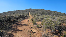
Sycuan was my second planned hike after Mother Miguel. I had lunch with Parker in between and it was a game time decision based on the ankle. It felt strong enough to handle another easy hike. The trailhead for Sycuan was on Lawson Valley Road. However, there were no road signs at a tight pull off area on the north side of the road. I drove past it the first time. The only indication of a trail was a chain with a small sign that read Boundary Ecological Preserve. I ventured past the sign on what looked like an abandoned road. It shrunk to a single track at one point, then expanded again. The trail was deeply rutted in places. The summit had an electric (or telephone) pole with wire going over and down the other side. An 8' boulder marked the high point. I stood on the boulder with unease, testing my stability at an odd angle. Felt solid enough, though I was very careful getting down. I didn't find the benchmark, but didn't spend much time looking. I found a mason jar with something inside, but it looked like tissue instead of a register, so I didn't open it. There were great views of Corte Modera, Lawson, and Gaskill. I snapped a few photos, then returned to the truck without meeting another soul. Sycuan had enough prominence to bump my P-index to 196, an unexpected plus.


Great to see you out again! What a drag being injured.
ReplyDeleteMike Martin
Mike,
DeleteThanks. Healing has been frustrating and slow, but I still have ambitious plans for the year. Hope you are out enjoying the mountains.