Distance: 9 miles round trip on trail and cross country
Summit Elevation: 3075'
Prominence: 324'
Elevation Gain: 2177'
Elevation Gain (in Empire State Buildings): 1.74
Round trip time: 4 hours 15 minutes
Recommended water: 84 oz.
Parking/Fees: Adventure Pass
Difficulty: Moderate
When I first looked at a map of Bluewater Canyon, I wanted to find the highest peak on the perimeter to get the best view. In June, 2016, I unsuccessfully attempted to climb peak 3070+. It was only after reviewing my track the next day that I realized it was not the highest peak on the perimeter, but the second highest. I had tried to climb the wrong mountain, an "Unintended Peak". The following month, I climbed the highest perimeter peak, Bluewater Crown. Although this peak dropped lower on my to do list, I didn't forget it. This hike was a first ascent (AFAIK). The peak was previously unnamed and unmarked.
But I'm busy mending broken
Pieces of the life I had before"
-- Muse, Unintended
A quick recap of my first attempt. From 4 Corners, the North Tenaja trail winds around the peak to the east side where an obvious wide gully looked like the best bet. Unfortunately, about half way up it turned very nasty. The chaparral in the Santa Ana mountains is some of the most dense and brutal I've encountered. Sometimes, it takes an exceptional effort to force your way though. I made attempts left and right of the gully, then toward the ridge line hurling bone and blood against root and sap. All those routes collapsed into 15' high walls of brush. I clawed back to the trail and made a fourth effort up a less friendly looking gully that appeared to have helpful boulder outcrops. I felt the last route was workable, but I could not complete it. I was too exhausted from the prior attempts and completely out of water. Cast down with blackened feathers, I stumbled back to the car and drank two bottles of water before driving home. For the second attempt, I headed directly back to the promising route carrying extra water and humility.
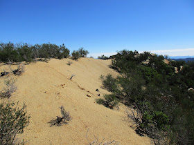
After a relentless, wet winter, I was not surprised to find water flowing in the small stream that crosses the Bear Canyon trail. The trail itself was a running stream in sections leading up to 4 Corners. This led me to believe the plant life in my ascent gully might have exploded, making it more difficult than last June. When I reached the ascent point, I stopped for a break. I put on gaiters, gloves, and got the clippers ready. The nice weather had me on guard for reptile friends, so I probed hidden areas with my trekking pole and stepped carefully. The strategy I used last time continued to work. I headed for the biggest outcrop of boulders, climbed up, then aimed for the next, and the next. I clipped spots that were dense and crashed through lighter stuff. My concerns about the water causing explosive growth were unfounded. In fact, the torrents had uprooted or weakened a lot of brush, making it easier than my first attempt. The slope grew steeper as I got higher, but the rocks did not exceed class 2. The crux was a 30' thicket past one of the largest boulders. After that, the slope angle eased and the brush got lighter. Other than a few yuccas, there were no thorny plants, and I didn't see any poison oak. Because this is not an area sane animals travel, there were no ticks. A cluster of small boulders made up the summit. I wandered around the top and looked into the massively eroded gully on the east side. There was a huge difference in the brush and difficulty between the two gullies. I placed a register in a plastic jar at the summit with a painted "solitude" rock. It was nearly a flawless execution, except I forgot to bring a pen to leave in the register. Doh! If you are reading this and climb the peak, please bring a pen to leave in the register jar. Thanks!
On the way down, I wandered a little from my ascent track, but tried to stick to outcrops. It wasn't long before I was back on the North Tenaja trail, just in time to dodge two mountain bikers screaming around a corner. I had twigs and leaves in my shirt, my pockets, and had to stop twice to remove twigs from my underwear. It was that kind of day. I finished faster than I expected, so I dropped my pack in the car and walked the short distance down the San Juan Loop trail to check out the waterfall. It was in full song. I scrambled down close to the base of it for some nice photos before going home. It was a satisfying day to get this one.
Unintended Peak from Keith Winston on Vimeo.


Good work. Any thorny plants along the route?
ReplyDeleteSean,
DeleteI should have mentioned, there are only a few yuccas and nothing else thorny. Mostly small trees, shrubs, manzanita, and grass. The bad gully had bigger trees and was a lot more dense. There is a lot more manzanita growing on the north slopes. No poison oak and no ticks. I'll add that info above.
Thanks for the beta. I left a pen.
ReplyDelete-gimpilator
Gimpilator,
DeleteAwesome! Appreciate it.