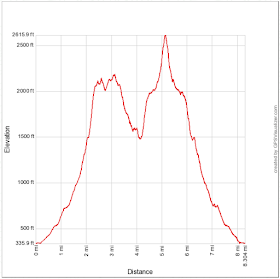
Distance: 8.3 miles round trip on use trail and cross country
Summit Elevation: 2250'(Indio), 2500' (Coyote)
Prominence: 746' (Indio), 1133' (Coyote)
Elevation Gain: 3401'
Elevation Gain (in Empire State Buildings): 2.7
Round trip time: 7 hours 30 minutes
Recommended water: 112 oz.
Parking/Fees: Free at Cove Oasis Trailhead
Difficulty: Strenuous
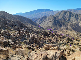
Indio Mountain and Coyote Benchmark are peaks rising above Coachella Valley, technically foothills of the Santa Rosa Mountains. They sit on a ridge between the desert communities of LaQuinta and Palm Desert. Coyote is the highpoint on the ridge. I parked at the Cove Oasis Trailhead and started along the Bear Creek trail. I took stairs down/up to cross a levee and reach the wide gully between the two peaks. There was a decent use trail leading two miles up the gully and ending at the saddle. The use trail fades in the middle, and I lost it briefly both on the way up and the way down. From the saddle, I turned right (north) to gain the ridge to Indio. There were some ups and downs along the ridge and a fun class 2 scramble to the Indio summit. Bob Burd had placed a register in 2019, but the most recent report indicated it was no longer there. I could not find it either, but I did bring another one in a plastic sandwich container and left it at the high point with a pen. Indio was a nice 360 perch to look down on LaQuinta and several golf courses. San Jacinto and Martinez Mountain filled the north and south horizons. When I left the peak, I veered south to eyeball a gully system as a possible alternative to returning along the ridge. The terrain was rough and I was concerned I might cliff out, but the penalty would only be 400' extra gain to get back on the ridge. I picked my way down the gully and didn't encounter anything more than class 2. I had to side hill around the waist of the first slope to avoid losing elevation. The gully route might be a little easier than the ridge. It was certainly more direct with slightly harder navigation.
I rested a few minutes at the saddle, then started up the left (south) side toward Coyote BM. The south slope was even steeper than the north. After reaching the top of the slope, there was a somewhat flat, rocky, half mile traverse to reach the base of the final hill. I hiked up hitting more class 2 at the top. The summit is on the edge of a deep canyon to the south. A broken wooden pole and some wire served as a marker at some time in the past. Views were impressive in all directions. I found a register jar that contained a small book and some loose scraps. One of the loose scraps had the signature from Eric Su when he did the entire ridge traverse in 2017, in the dark no less. I stayed on top for 10 minutes before starting the slow, careful descent. It was less than a mile from the saddle to the Coyote BM summit, but my round trip time from the saddle was 3 hours, longer than I would have guessed. The use trail back to the truck was uneventful. These are stout little peaks, which probably explains why they are seldom visited. While I know there have been many more ascents than shown in Peakbagger, my ascents of Indio and Coyote BM were both the 7th recorded.
Would you like to know more...?


