Sunday, April 25, 2021

Queen Mountain and Queen Benchmark

HPS Star Emblem Peak
Hiked: 4/23/2021
Distance: 4.4 miles round trip on trail
Summit Elevation: 5680' (Queen), 5677' (Queen Benchmark)
Elevation Gain: 1432'
Elevation Gain (in Empire State Buildings): 1.1
Round trip time: 3 hours 10 minutes
Recommended water: 32 oz.
Parking/Fees: $30 National Parks Fee (1 car good for 1 week)
Difficulty: Moderate (navigation)

Queen Mountain (HPS #217) was the third of my planned peaks in JT for the day. The closest parking is a turnaround not far from the base. Queen Valley Trail is a one way road, so I took Queen Valley Road and turned north onto O'Dell Road to reach the trailhead. I was able to take Queen Valley Trail on the way out.

I started north from the turnaround and followed an old road that goes around bump 4628'. The road ends at the base of the mountain but a single track use trail takes over from there. I had planned 4 hours for the trip expecting it to be cross country. The use trail with periodic cairns made it easier than expected. After gaining some elevation, the trail side hills into the major drainage that separates Queen Mountain (hiker left) and Queen Benchmark (hiker right). I headed left to Queen Mountain first. The upper part of the drainage has some class 2 as well as the big summit block. On top was a reference mark pointing 0.2 miles away to the official but lower by 3' benchmark. I also found and signed the HPS register. Great views in all directions with lots of unusual rock formations. By far, the best views of the day. The Wonderland of Rocks was also in sight. After a quick photoshoot, I climbed down and followed a different use trail to Queen Benchmark. In addition to the benchmark, there was a large plastic ammo box with many registers. I think all of them were placed by the Boy Scouts, who use this mountain for navigation training. It was odd the official mark was placed on the lower of the two summits, but it was impossible to tell without precise instruments so I gave the USGS some slack. I had to make two course corrections on the way back after following the wrong set of cairns. I found the use trail a little harder to follow on the way down in the side hill section. I was on the fence about whether to rate this hike easy or moderate. The Sierra club rates it moderate so I'll leave it that based on navigation. Queen was a lot of fun.


Approaching the summit block

Reference mark on Queen Mountain pointing across the drainage to the BM


This was on the north side of Queen BM, couldn't figure out what it was


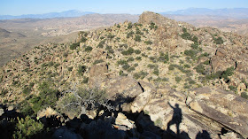
Looking at Queen from Queen BM


Saturday, April 24, 2021

Warren Point and Eureka Peak

Hiked: 4/23/2021
Distance: 5.5 miles round trip on trail
Summit Elevation: 5106' (Warren), 5518' (Eureka)
Elevation Gain: 1078'
Elevation Gain (in Empire State Buildings): 0.8
Round trip time: 2 hours 15 minutes
Recommended water: 36 oz.
Parking/Fees: $30 National Parks Fee (1 car good for 1 week)
Difficulty: Easy

This was a Joshua Tree HPS roundup. I aimed for three peaks on the day: Warren Point, Eureka Peak and Queen Mountain. The starting point for Warren (HPS #270) is the Black Rock Campground Visitor Center. The park was crowded and I got the last parking spot. The trail to Warren (NPS signs call it Warren Peak) starts behind the visitor center going south. The trail is wide and sandy like walking on the beach. There were a dozen parties coming and going, though not all of them were bagging Warren. Newer metal signs marked trail junctions along with some wooden posts. I was about half a mile from Warren before I could positively identify it. I wasn't sure the trail went all the way to the top but it did. The summit had a benchmark and reference mark. It also had a tin can stuffed with full registers. Summit views were nice with San Jacinto looming large, snow still packing the north facing gullies. I considered leaving the trail to take a ridge shortcut on the way back, but didn't. Might have added some spice.


From the visitor center, I started the long dirt road drive to the Eureka (HPS #234) trailhead. If I drive between trailheads, I usually make a separate report, but Eureka didn't deserve it's own report. I knew Eureka was short but hadn't really done much research. The roads were in good shape and I didn't need 4x4 or high clearance at any point. From the trailhead, it is only 0.2 miles to the summit, it's really a drive up. It took five minutes to walk to the summit with no pack. No marks and no register. Views were similar to Warren Point but better.

Eureka from the parking turnaround, Gorgonio behind

San Jacinto


Sunday, April 11, 2021

Martinez Mountain and Sheep Mountain

HPS Star Emblem Peak
Hiked: 4/6/2021
Distance: 18.1 miles round trip on trail and cross country
Summit Elevation: 6562' (Martinez), 5141' (Sheep)
Prominence: 1722' (Martinez)
Elevation Gain: 5444'
Elevation Gain (in Empire State Buildings): 4.3
Round trip time: 12 hours
Recommended water: 200 oz.
Parking/Fees: Adventure Pass at Cactus Spring Trailhead
Difficulty: Strenuous

First, the cougar. On the way back, Henry and I walked within 15' of a cougar resting in the shade under a small tree. Within 2 seconds, it bolted directly away from us at high speed. Had it charged, I doubt I would've had time to move before it reached me. It was a sureal moment and my first encounter with a cougar in the wild. My guess is it weighed between 100 and 120 pounds. Now back to the trip report.

Hardcore Henry and I met at the Cactus Spring Trailhead (5E01) planning a balloon style loop. The trail went close to Martinez (HPS #149, DPS #50) but Sheep Mountain (HPS #267) was a couple of miles off trail. We kicked off festivities at 6 AM with enough light to forgo a headlamp. The trail was well groomed and sandy, with a number of helpful wooden markers. About a mile in, we crossed Horsethief Creek with the only water on the hike. We were grinding heads down the first 6.5 miles to the base of Martinez. The two main routes were the southwest ridge and northwest gully. We decided to take the ridge up, gully down, then head cross country directly to Sheep. We left the trail for a steep slope and gained the ridge. On the ridge was a pretty good use trail with frequent cairns. The cairns were useful in showing the best route through the boulders. After topping three false summits, we finally reached the summit area littered with boulder stacks.


Horsethief Creek

Henry on the lower part of the ridge


We left our packs below for the solid class 3 climb. There were two ways up the first 15' to a ramp that led around to the other side where a 10' chimney got you to the top. The view from the top was inspiring, with Toro looming above, Rabbit to the south, and the mountains of Joshua Tree northeast. We unpacked the register from an ammo box. The register was placed in 2003 but was only about 1/3 full. As an HPS and DPS peak, I expected more visitors. After soaking in the summit, we down climbed and started down the gully.


Part way up, pack left below


Mighty Rabbit

Toro Peak


The gully looks very steep from afar. It is filled with mostly stable boulders and debris from runoff. Nothing was overly difficult or exceeded class 2, but it did demand attention. It was also long, dropping about 1500' before splitting into smaller channels at the bottom. By comparison, the gully route was more difficult than the ridge. Once we were out, we trekked cross country toward Sheep, hidden by intervening ridges and bumps. The high desert terrain was semi-open and included seveal kinds of cactus, junipers, cedars, and manzanita. There was enough space between the vegetation to allow steady progress. After a lot of ups and downs, we finally identified Sheep Mountain and circled a ridge to reach it. Sheep had an official benchmark and a register in standard HPS red cans. The oldest register was from 1983 and was badly weathered. We signed a newer one. We took our last break on Sheep then descended the ridge running southwest. Cairns marked a use trail to the bottom of the ridge before disappering. The way back to the trail was blocked by a ridge running perpendicular to ours. We debated whether to go around, but decided to power over it instead. Once we got over the ridge, we had a flat 1.5 miles back to the trail. It was here that we marched up on the mountain lion. After it ran away, I took a waypoint for reference. Until we got back to the trail, we checked the rear view frequently to make sure we were not followed. Back on trail, we met a red diamond rattlesnake. It was a 3' juvenile but old enough to warn us with a courtesy rattle. It crawled into an agave plant and remained agitated until we were out of earshot. The final four miles had about 700' of gain. Martinez/Sheep was a wonderful, big hike, exactly the kind of test I need from time to time.

Starting down the gully


Looking back at Martinez from Sheep Mountain


Descending Sheep toward the ridge obstacle

Looking back at Sheep near the mountain lion encounter

Juvie red diamond


Tuesday, April 6, 2021

Lost Horse Mountain

Hiked: 4/6/2021
Distance: 4.4 miles round trip on trail and use trail
Summit Elevation: 5313'
Prominence: 433'
Elevation Gain: 1568'
Elevation Gain (in Empire State Buildings): 1.2
Round trip time: 1 hour 45 mintues
Recommended water: 36 oz.
Parking/Fees: $30 National Parks Fee (1 car good for 7 days)
Difficulty: Easy

Leisa and I drove down Lost Horse Road, a well graded dirt road to the trailhead for Lost Horse Mine. There was a sign at the entrance to the road that said the lot was full. Indeed, it was full when we arrived. I started to turn around when a family waved at us that they were getting ready to leave. It was a lucky start.

The trail rolls gently up and down before climbing steadily to the Lost Horse Mine. The mine is well preserved and surrounded by high fencing. It actually produced over 9,000 oz. of gold in the 1800s and 1900s. Lost Horse Mountain (HPS #250) is not directly above the mine. Instead, it is across the trail. After poking around the mine, we continued on the Lost Horse Loop up to the saddle below Lost Horse Mountain. Leisa waited for me while I climbed the final bit of ridge to the top. There was a fantastic view down to Geology Road and Malapai Hill. I had climbed Malapai several years ago while working on the Lower Peaks List. There were no markers or registers that I could locate. It wasn't until I was on top of Lost Horse Mountain that I realized my GPS was off. I turned it on for the descent, but the track doesn't include the short side trip to the mine. Limited parking is the only thing that kept this trail from being too crowded.


The mine


Final ridge climb

Malapai Hill

Lost Horse summit

Looking back toward the mine